Deze cache is ALLEEN te doen tijdens de (beperkte) openingstijden van het Natuurbelevingcentrum de Oostvaarders. Kijk op de site van dit centrum voor de juiste openingstijden!
You can ONLY do this cache during (the limited) opening hours of the Natuurbelevingcentrum de Oostvaarders. Check the site for the correct opening hours!
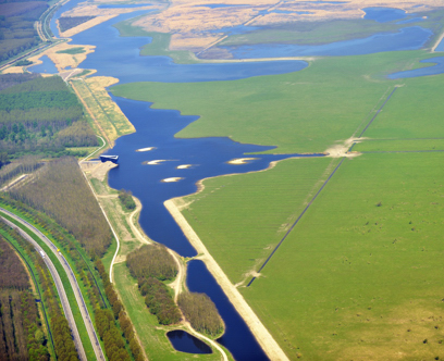
(adopted from Langzaam en timker)
In de bodemopbouw en de sedimentsamenstelling van Flevoland is de dynamiek en de geschiedenis van de Zuiderzee (en haar voorgangers Flevomeer, Aelmere) nog duidelijk herkenbaar.
In de laatste ijstijd (Weichselien circa 40.000 jaar geleden) traden hoofdzakelijk twee processen op. Nederland was in deze periode grotendeels een kale vlakte waardoor veel verstuiving van zand plaatsvond. In de ondergrond van Flevoland komt voornamelijk dekzand voor. In het zuidelijk deel van de Noordoostpolder ontbreken deze afzettingen. Hier bestaan de afzettingen voornamelijk uit rivierafzettingen van de Rijn en de Vecht.
De periode daarna tot heden, het Holoceen genoemd, is op de dekzanden en rivierafzettingen een veenpakket afgezet. De zeespiegel en het grondwater in het dekzand stegen en veen werd gevormd. Dit zogenoemde ‘basisveen’ vormt nu door inklinking een dunne, moeilijk waterdoorlaatbare laag die her en der in de ondergrond van de polders terug te vinden is. In de Noordoostpolder is deze laag in vrijwel het gehele gebied aanwezig en varieert in dikte van 0,1 tot 1,0m. In de Flevopolders is deze laag nog aanwezig langs de dijk bij het Nijkerkernauw en lokaal langs de oostrand van de Flevopolders. Nadien zorgden rivier- en zee-invloeden voor een zeer gevarieerde bodemopbouw (rivierduinen, stroomgeulen, detritusafzettingen en afzettingen van Flevomare, Zuiderzee). De grondsoorten in de polders zijn zand, zavel, klei en veen. Op een aantal plaatsen (Urk, Schokland en in het Voorsterbos bij Kraggenburg) zit keileem in de bodem. Dit keileem is circa 160.000 jaar geleden door het oprukkende ijs afgezet. Deze keileemruggen zijn een mengsel van klei, zand en stenen en klinken niet in, in tegenstelling tot het omliggende klei en veen.
In de polders is een duidelijke afname van de maaiveldhoogte vanaf het ‘oude land’ naar het centrum van de voormalige Zuiderzee. De Zuiderzee als geheel was min of meer een kom. Na het droogvallen van de polders treedt er door allerlei processen bodemdaling op. Door rijping van de klei, oxidatie van veen en onttrekking van bodemvocht krimpt de bodem in. Vanwege de verschillen in bodemopbouw en de leeftijd van de verschillende polders is er sprake van grote verschillen in reeds opgetreden en nog te verwachten bodemdaling. In Zuidelijk Flevoland is de verwachte daling het grootst: gemiddeld 30-60 cm en plaatselijk meer dan 60 cm (zichtjaar 2050). In Oostelijk Flevoland en de Noord-oostpolder is de komende bodemdaling het geringst: gemiddeld 10-20 cm en plaatselijk 30-50 cm (zichtjaar 2050).
The soil structure and sediment composition of Flevoland, the dynamics and history of the Zuiderzee (and its predecessors Flevomeer, Aelmere) are still clearly recognizable.
In the last ice age (Weichselien about 40,000 years ago) there were mainly two processes active. In this period, The Netherlands was mainly a barren plain so a lot of sand spraying sand took place. The subsurface of Flevoland contains mainly “geest”. In the southern part of the Noordoostpolder these deposits are missing. Here, the depositions are mainly from river deposits like the Rhine and the Vecht.
From that period until the present, named the Holocene, the geest and river depositions set off peat-soil. The sealeavel and the groundwater in the geest increased and peat was formed. This so-called 'basic peat' was developed by setting a thin, difficult water permeable layer that is found in some places around the polders. In the Noordoostpolder this layer is almost everywhere in the entire area and varies in thickness from 0.1 to 1.0 m. In the Flevopolder this layer is still present along the dike near the Nijkerkernauw and close to the eastern edge of the Flevo polders. After that, river and sea influences created a very diverse soil structure (river dunes, ditches, detritus segments and depositions of Flevomare, Zuiderzee). The soils in the polders are sand, clay and peat. In some places (Urk, Schokland in Voorsterbos in Kraggenburg) is the soil filled with bolder clay. This bolder clay originated approximately 160,000 years ago by the encroaching ice. This bolder clay is a mixture of clay, sand and stones and doesn’t set, unlike the surrounding clay and peat.
There is a clear decrease in the polders at service level from the 'old land’ to the centre of the former Zuiderzee. The Zuiderzee was shaped like a bowl. Due to various processes after dehydration, the polders set in. By aging of the clay, oxidation of peat and declining of soil moisture, the soil shrinks. Due to the differences in soil structure and the age of the different polders, there are large differences in already occurred soil subsidence and expected subsidence. In 2050, in Southern Flevoland, the expected decrease will be the highest; average 30-60 cm and locally more than 60 cm. In Eastern Flevoland and Noordoostpolder (also in 2050) is the expected subsidence the lowest: average 10-20 cm and 30-50 cm local.
De opdracht voor deze Earth cache bestaat uit 6 vragen die grotendeels te vinden zijn op het informatiebord en de houten paal aan de andere kant van het pad:
1) Wat voor een gebied was dit voordat het een moerasgebied werd? Een nat .......gebied (deze info was te vinden in het Natuurbelevingscentrum, maar wegens een te kort aan folders is deze informatie nu te vinden op de achterkant van het informatiebord).
2) Vraag m.b.t. de inklinking van de grond: op hoeveel centimeter onder de zeespiegel bevinden je schoenen zich bij het informatiebord (voor cachers die een GPS zonder hoogtemeter hebben: kijk op de achterkant van het informatiebord)?
3) Hoeveel vogels staan er op het informatiebord afgebeeld (dit bord is in 2010 veranderd)?
4) Wat is de afstand van het Natuurbelevingscentrum tot het Spoorwegstation Almere Oostvaarders?
5) Hoeveel minuten is het wandelen vanaf hier naar dat station?
6) Dit is een Internet vraag geworden: In Frankrijk onder Arles en in Spanje nabij Sanlucar de Barrameda liggen belangrijke Europese natuurgebieden, welke zijn dit?
Om te bewijzen dat je er echt geweest ben plaats je bij je log een foto waarop in ieder geval je GPS staat en het Natuurbelevingscentrum.
To fulfil this eartchache, you have to answer 6 questions. You’ll find the answers at the parking space nearby the visitor centre. There is an information signboard and a wooden pole with extra information there.
1) Nowadays the Oostvaardersplassen are Marsh land. What kind of land was it before that? A wet .......land (normaly you’ll find this information in Dutch at the visitor centre, but due to a shortage of leaflets this information is now at the back of the information signboard).
2) About the land subsidence: How many centimetre below sea level are your shoes at the information signboard (for cachers with a GPS without altimeter: check the back of the information signboard)?
3) How many birds are there on the information signboard (this is changed in 2010)?
4) What is the distance from this spot to the railway station Almere Oostvaarders?
5) How long will it take to walk from this spot to that railway Station?
6) This has become an Internet question: what are the European nature reserves in France near Arles and in Spain near Sanlucar de Barrameda, please give the names?
To prove that you really visited the site you have to include a photo with your log, that shows your GPS and the visitor centre.
De cache is tot stand gekomen met medewerking van Staatsbosbeheer.
This cache is possible by the cooperation from Staatsbosbeheer.