Cape Algonquin EarthCache
-
Difficulty:
-

-
Terrain:
-

Size:  (other)
Please note Use of geocaching.com services is subject to the terms and conditions
in our disclaimer.
The coordinates bring you to a parking lot that is the trailhead for the Barron Canyon Trail. The 1.5 km hike takes the visitor up to a steep cliff and way back into the history of the Algonquin lowlands.
The Barron Canyon is for sure one of the most fascinating geological features in the Algonquin Provincial Park.
This cliff was referred to as ‘The Capes’ by the log drivers that used the river for timber transportation in the 1800’s and early 1900’s.. The rock formations at both sides of the Canyon are part of the Canadian Shield. These very hard and crystalline rocks are called Gneiss. Gneiss (‘nice’) is the result of pressure and high temperature deep within the earth’s crust. Under these conditions older rocks of various kinds are becoming liquid and are transformed into new shapes and structures. These metamorphic rocks were once ‘igneous’ rocks - meaning they were injected as magma during a mountain building events in this area or soft sediments deposited at the earth’s surface. Granite and Lava are both types of igneous rocks.
All the rocks we find today in Algonquin are of the same kind. They were built into mountains just 1.200 million years ago when the continent of Atlantica pushed over the edge of the continent Nena. Large blocks of the crust were piled up and formed the Grenville mountains. Back then the land we see today in Algonquin today was buried 25 to 30 kilometers deep underneath the surface. It took millions of years of erosion, the breaking apart of several continents and the relentless movement of the continents to finally expose today’s rocks of Algonquin. Imagine that it takes 10 years to erode just one millimeter of gneiss!
The Canyon itself has been shaped just recently as a result of the last Ice Age, approx. 11.000 years ago. The original groundwork for the Canyon however was done some 500 million years ago when the temporarily submerged area lifted up and broke apart into several northwest-trending blocks with some faults. Progressing erosion on both sides of the Barron fault increased the width and depth and formed the Canyon that we see now.
At the end of the last Ice Age the up to 3km thick layer of Ice and Snow retreated northwards – exposing the Algonquin Park which then was home of an arctic tundra like habitat. To the northwest of the Park the huge Lake Algonquin was formed by the melting waters of the retreating ice shield. Originally drained through the Mississippi the melting water suddenly changed direction when the disappearing ice gave way to a drainage through the Fossmill channel in Algonquin Park.
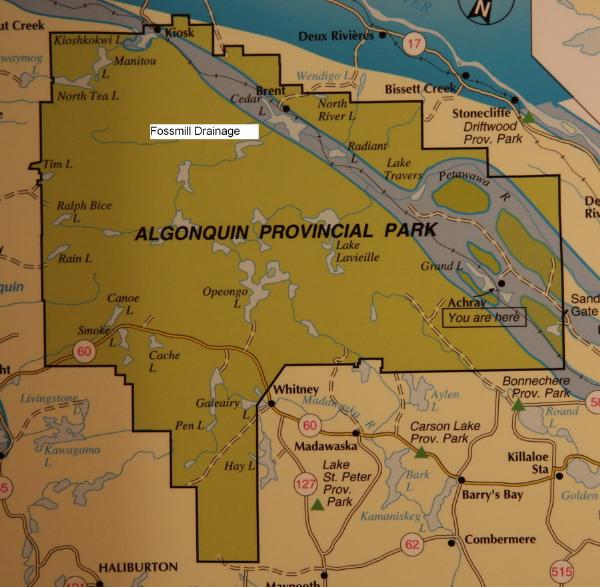
Pic 1: Fossmill Drainage
The Barron Canyon was part of this line of lower lands of the Fossmill fault. The amount of water funneled through this new drainage system must have been enormous. Some geologists estimate that the Barron River carried as much water as 1.000 Niagara falls!
This spectacle however was short lived. The ice shield further retreated and an even lower drainage outlet of Lake Algonquin was revealed. With the access of the water to the Lake Nipissing-Mattawa channel the Barron River water was reduced to a slow flowing water way.

Pic 2: Barron Canyon
For you in order to log the cache please send the following answers by email:
a. At what post along the trail do you reach the highest elevation level?
b. What is the difference between the parking lot elevation and the highest point of the trail?
c. How many years will it take to erode the cliff down to the parking lot level?
d. What is the name of one of the ice age animals that still populate the lakes along the Fossmill drainage?
e. Post a picture of you with your GPS with the backdrop of the Barron Canyon together with your log.
f. Post a picture of your favorite spot, animal or plant in the eastern lowlands of Algonquin.
Additional Hints
(Decrypt)
q. Cvpx hc bar bs gur oebpuherf (cyrnfr cnl gur fznyy srr) naq fghql vg.
Treasures
You'll collect a digital Treasure from one of these collections when you find and log this geocache:

Loading Treasures