Nappa Scar is a key locality in the Lower Palaeozoic
inlier and is a Sub-Carboniferous unconformity.

Nappa scar on the approach path with the Norber Erratics in
the background - The unconformity is in the tree line NOT at the
base.
Pebbly limestone and conglomerate on lap a palaeocliff in
cleaved calcareous siltstone of the Upper Ordovician (Ashgill)
Norber Formation. The path you are standing on is the Ordovician
basement whilst the horizontal stratum higher up is Carboniferous
Great Scar Limestone.
An unconformity is a buried erosion surface separating two rock
masses or strata of different ages, indicating that sediment
deposition was not continuous. In general, the older layer was
exposed to erosion for an interval of time before deposition of the
younger, but the term is used to describe any break in the
sedimentary geologic record.
The phenomenon of angular unconformity (see below) was
discovered by James Hutton, who found examples at Jedburgh in 1787
and at Siccar Point in 1788.
The rocks above an unconformity are younger than the rocks
beneath (unless the sequence has been overturned).
An unconformity represents time during which no sediments were
preserved in a region. The local record for that time interval is
missing and geologists must use other clues to discover that part
of the geologic history of that area. The interval of geologic time
not represented is called a hiatus.
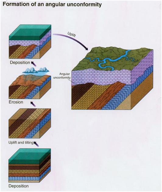
Angular unconformity is an unconformity is where horizontally
parallel strata of sedimentary rock are deposited on tilted and
eroded layers, producing an angular discordance with the overlying
horizontal layers. The whole sequence may later be deformed and
tilted by further orogenic activity.
Questions; (answers on an e-mail to me via my profile,
please don’t post them on your visit log)
What does ‘Orogeny’ mean? (Use the internet)
Estimate the thickness of the layer between the top of the
unconformity and the upper horizontal strata and describe its
appearance (Look closely – it’s very distinctive.)
Is this layer harder or softer than the strata above; and how do
you know? Please don't dig at either layer -
you can tell by looking and thinking.
Estimate the total height to the top of the scar.
Post a picture of you and/or GPS at the posted coordinates showing
the unconformity. Logs without a picture and/or wildly inaccurate
answers may be deleted.