A Turbulent Time in History EarthCache
A Turbulent Time in History
-
Difficulty:
-

-
Terrain:
-

Size:  (not chosen)
Related Web Page
Please note Use of geocaching.com services is subject to the terms and conditions
in our disclaimer.
Welcome to the Santa Monica Mountains National Recreation Area EarthCaching Program. This earthcache site is available year round. This cache is on trail. Please do not travel off trail for your safety and preservation of resources.
Located at the Castro Crest area, this cache provides views of the mountains, canyons, the Pacific Ocean and, on clear days, the Channel Islands can be seen from this trail.
Information regarding Castro Crest Area.
• Castro Crest should be visited from sunrise to sunset for your safety.
• All plant material, rocks, animals, and historical features are protected by law and may not be collected or disturbed.
• Safety information:
- Poison Oak can be found in this area. It is identified by three leaves ranging in color from green to crimson. The plant is deciduous, so it does lose its leaves in the winter.
- Watch out for mountains lions, rattlesnakes and ticks.
National Park Service Visitor Center Information:
Open daily from 9 AM – 5PM.
Address: 401 West Hillcrest Drive, Thousand Oaks, CA, 91360
Phone number: 805-370-2301
www.nps.gov/samo
In emergency: dial 911
Vocabulary:
Epoch: An interval of geologic time that can range from 10,000 years to 15 million years long.
Miocene: Geological time epoch from 23.8 to 5.33 million years ago.
Clastic: A sedimentary rock made up of fragments of other rocks. These fragments can be either angular or rounded in shape. In this case they are rounded.
Marine: To be of ocean / sea origin. In this case deposited under water.
Oligocene: Geological time epoch from 33.7 to 23.8 million years ago.
Sediment: Small to large size pieces of rock. Sand is a good example of sediment.
Turbidites: Geological features created usually by underwater landslides or other massive soil movement.
Geological Information
Twenty million years ago, during the Miocene Epoch, the rock you are standing today would have been underwater.
Take a look around where you are standing. You’re on top of a mountains! Just about two miles from here is one of the highest points in the Santa Monica Mountains, Castro Crest. At an elevation of 2,824 feet, Castro Crest is made of the same rock you are standing on, the Lower Topanga Formation.
So how do we know that this rock you are standing on was underwater? Let’s go back even before you would have been underwater, long before 20 million years ago. Rocks from earlier time periods in this area are clastic and made up of marine clay shales, sandstones, and even chunks of minerals that make up granite such as quartz. The source of these clasts are the mountains east of Los Angeles out towards the Mojave Desert. During this time, the earth was very warm and sea level would have been quite high. In fact, temperatures were some of the warmest in history.
Then in the Oligocene Epoch, about 34 million years ago, the weather began to shift. The Earth began to cool. What would have been lush forests in this area became dry woodlands and savannahs. Because of this cooling off, the seas began to retreat and the ice caps began to grow.
Yet the story doesn’t end there. Around 24 million years ago, the sea level began to rise, again. The earth was just starting to take the shape we know it to be today. It was cooler and drier than ever before in history. The sea level was higher than present time. Some of the modern animals and plants we know of today were beginning to appear. Whales and grasses such as oats, wheat, and rice first started to evolve. The Rocky Mountains were starting to grow. Here in the Los Angeles Area, the Santa Monica Mountains did not even exist!
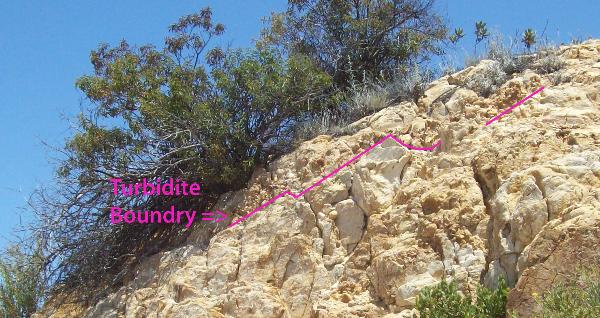
Now look towards the exposed rock face to your right, you’ll see whites, yellows, browns, and even reds. If you now look at the shape of the sediment that makes up the face, you’ll see large rounded rocks, you’ll see small pebbles, and you’ll see fine sand grains. Now look at how they are layered. What you’re looking at is a landslide that was underwater. In fact you are looking at many underwater landslides! These are known as turbidites.
Each turbidite can be seen if you draw an imaginary line between the biggest rounded rocks and the finest grain sands, with the biggest round rocks on top.
After about 7 million years of the landslides going on something big happened; the Santa Monica Mountains were born! The rock you are standing on was lifted from the sea by the rising of volcanoes as they rose to a height of over to 10,000 feet during the next 4 to 6 million years. With this rapid uplift, the Lower Topanga Formation was pushed and carried alongside these new volcanic rocks as the mountains grew.
Once the volcanoes went extinct and the elements started to take their toll on this new rock, the turbidites that were covered up were re-exposed to what we see today, marine clasts on a mountain top.
Now that you know you can find evidence of marine rocks on a mountain top, travel to the highest point in the Santa Monica Mountains, Sandstone Peak. To find out if this is a good name or not, you can visit the Sandstone Peak EarthCache by clicking here.
Quiz
There is no quiz for A Turbulent Time in History. Please e-mail the answers to us to verify for credit.
Q: When you got to the parking lot at the top of Corral Canyon, who owned the land?
Q: How many turbidity flows can you count at this cache?
Q: Where do you think the rock and sediment from here ends up?
Sources:
-Dibble Jr., Thomas W., Ehrenspeck, Helmut E., 1993, Geologic Map of the Point Dume Quadrangle, Los Angeles and Ventura Counties.
-Santa Monica Mountains National Recreation Area, National Park Service, 2009, www.nps.gov/samo.
-Stanley, Steven M., 2002, Earth System History, W.H. Freedman and Company, p.519 -556.
-Tom Harrison Maps, 2009, Malibu Creek State Park Trail Map, Tom Harrison Maps.
Additional Hints
(Decrypt)
Ybpngrq ba ACF Cebcregl guerr graguf bs n zvyr sebz cnexvat ybg.