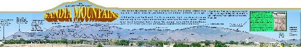
above extracted from Albuquerque's Geoscape poster[1]
An unconformity refers to “any break in the sedimentary geologic record” where “sediment deposition was not continuous.” In other words, successive layers or adjacent rocks were not formed one after another but a gap exists in their respective ages. “An unconformity represents time during which no sediments were preserved in a region. The local record for that time interval is missing and geologists must use other clues to discover that part of the geologic history of that area. The interval of geologic time not represented is called a hiatus.”[2]
A significantly large age gap or hiatus that is visible in different places in the U.S. is known as “The Great Unconformity.” Some sources speak of one global Great Unconformity, while others discuss many around the world with this as “one of the largest.”[3] I'm prone to think that in some places, there are just significant gaps in the geologic record. Regardless, the Great Unconformity is evident right here in the Sandias. Other well-known viewing locations are in the Grand Canyon and at Frenchman Mountain near Las Vegas, Nevada (see GC18Z8Y).
Most sources attribute the term to John Wesley Powell, dubbed during his famous trip through the Grand Canyon in 1869 where he no doubt observed the “incredible and striking contrast… in the rocks.”[4] However Stephen Rowland, Professor of Geology at UNLV, attributes the term "Great Unconformity" to Clarence Dutton in his 1882 book Tertiary History of the Grand Cañon District.[5]
Here the 1.4 billion year old Sandia granite (igneous) is overlain by 320 million year old Pennsylvanian sedimentary rocks known as the Madera formation and composed of mostly limestone with some sandstone and shale. As Dr. Matthew Heizler, geochronologist at New Mexico Tech observes, this 1.1 billion year “gap in the rock record… represents nearly a quarter of the earth's geological history.”[6]
Professor Heizler also notes that “the contact between limestone and granite can be seen easily at Sandia Crest, which shows many horizontal layers. Further down the mountain granite makes up the majority of what we see. We estimate that the Great Unconformity represents 1.1 billion years of time by examining radioactive decay of elements within the granite. We have found that the Sandia Granite is 1.4 billion years old. Fossils let us know that the limestone is 300 million years old.”[7]

What happened to the billion years in between? What happened during that time when no rocks were preserved? You can make your own guess, but accepted explanations are that either no rocks were formed here during that time, or rocks were formed but then eroded away.[8]
The posted coordinates are near the intersection of the Crest Spur and La Luz trail, or Mike Coltrin’s waypoint CSPLLZ, N 35° 12.276'W 106° 26.849'. Amazingly enough, when we arrived at this very spot we happened upon a very knowledgeable Forest Service ranger (we missed his name) hiking with Penn State Geology Professor Ray Fletcher. When we explained that we were looking for up-close evidence of the Great Unconformity, we received an expert explanation from the ranger and a personal tour from Professor Fletcher! He even climbed the granite boulders in the first photo (about 150 feet south) to show us the sandstone on top and behind a bit. As we continued south on the trail we saw more sandstone in the trail itself. Back at the trail junction we walked on granite, but 50 feet up the trail to the northeast, we were walking on limestone (2nd photo). We had found it! Along the trail in both directions!


To log this EarthCache:
1. Review this Hiking Safety page and Mike Coltrin’s Preparation page. Understand as with all hiking on this mountain, you should come well prepared with plenty of water, good footwear (hiking boots are best), and adequate seasonal weather protection. This trail is rocky, sometimes steep, and is near drop-offs. With the altitude around 10,000 feet above sea level, it can be very strenuous. Additionally, the weather is unpredictable and the Crest Trail and the upper La Luz trail can be impassible due to snow from November to April.[9]
2. Hike to the trail junction and observe the geologic dividing line first hand. It is best to reach this location from the top, either from the Tram (ticket rates) or from the Crest: CRSTPK, N35° 12.679', W106° 26.958' ($3 parking fee). Hiking from the bottom also requires the parking fee and entails a difficult hike. Unfortunately, rescue operations involving the unprepared or over-optimistic occur regularly in this section. Don't become a foolish statistic or worse! In your log, post a photo of yourself and/or your GPSr at the posted coordinates or in front of nearby rocks, either granite or limestone/sandstone. As of 1 January 2011, photographs are optional, but we'd still like to see what you saw! Identify the type of rock in your photo (easier) or describe it (color, roughness) in your log.
3. Near the posted coordinates at the trail junction, you should see some reddish granite boulders (red due to the potassium feldspar component). What about these particular rocks gives a clue to the billion-year mystery? Were no rocks were formed on top of them for over a billion years, or do you think rocks formed but eroded away before the new Madera sedimentary rocks were deposited? (Intentionally Cryptic Hint: Professor Fletcher happens to research ‘Spheroidal weathering and Saprolites’). The rocks Professor Fletcher climbed with us to the south also demonstrate the evidence. Send us a message with your answers to these two questions. Don't over-analyze, it's fairly straightforward.
Please Note: This area is a federally designated and managed Wilderness. As such, groups accessing the wilderness are limited to a maximum of 25 people.
This EarthCache was reviewed and approved by the management of the Sandia Ranger District, Cibola National Forest. Thank you!
References:
- Crumpler, L. S., Newsom, J., and Aubele, J. 2004, "Albuquerque's Geoscape": poster, http://www.joannewsom.com/AlbuquerqueGeology/(dead link)
- Wikipedia, “Unconformity”, http://en.wikipedia.org/wiki/Unconformity
- Wikipedia, “Great Unconformity”, http://en.wikipedia.org/wiki/Great_Unconformity
- Timmons, S., 2003, “GRAND CANYON GEOLOGY TRAINING MANUAL, Learning to Read the Pages of a Book for Grand Canyon National Park Interpretation Division”, p. 56. http://www.nps.gov/grca/naturescience/geology_manual.htm
- Rowland, S., “Frenchman Mountain and the Great Unconformity”, http://geoscience.unlv.edu/pub/rowland/Virtual/geology.html
- New Mexico Institute of Mining and Technology Geoscience research projects, “Recent and Ongoing NMBGMR Research Projects: Geochronologist studies missing rocks”, http://geoinfo.nmt.edu/geoscience/projects/great_unconformity.html
- Heizler, M., “Earth Matters script 1 Unconformity”, http://geoinfo.nmt.edu/events/esweek/scripts/Earth_Matters_script_1_Unconformity.pdf
- Lunar and Planetary Institute workshop, 2003, “Grand Canyon – The Great Unconformity”, http://www.lpi.usra.edu/science/treiman/greatdesert/workshop/greatunconf/
- Coltrin, M., “ SandiaHiking.com, Preparation”, http://www.sandiahiking.com/preparation.html