The North Downs are divided into two by the River Medway and the Eastern half stretches from Bluebell Hill near Chatham to the sea at South Foreland.
The landscape is such a valuable asset to the Nation that it was designated an Area of Outstanding Natural Beauty in 1968.
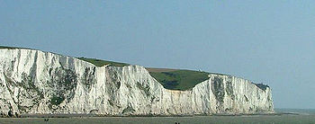
The Chalk Formation was laid down under the tropical sea during the Upper Cretaceous period 65 - 80 million years ago and was later uplifted at around 20 million years ago. The chalk deposits were formed into an elongated dome, in a roughly east-west direction.
Erosion along the central part of this line revealed the underlying lowland deposits which form The Weald of Kent. The remaining chalk forms the characteristic escarpments of the North and South Downs.
Today the White Cliffs of Dover are managed by the National Trust who are responsible for an eight mile stretch of the coastline. At the above coordinates you will find an information board next to the Visitor Centre and Café which is surrounded by car parking areas. The car park is free to members of The National Trust.
Non-members have to pay for cars. The car park is open dail from 7.30 am but closing time varies throughout the year.
In order to claim this Earthcache please complete the following tasks:
1. Take a photograph of yourself and/or your GPS at or near the Visitor Centre showing, in the background, either the Visitor Centre, Dover Castle or Dover Harbour.
2. What is the height above sea level of the Visitor Centre (from your GPSr). How old are these cliffs? (from internet and your previous answer).
3. What is the average erosion per year of the cliffs? (from the double sided main notice board at the centre and not the one with the tide tables).
If you have access to the internet you can send me your answers before logging your find, after all, thats only polite! Cachers who do not send me an email with their answers will have their logs deleted - amazingly thats about 10%. (It was running at 25% but since I added this line the number has dropped significantly). It is not sufficient to guess the answers and take a photo on the ferry!!
If you have internet access to log your find then you can also send me your answers at the same time.