IATCC – Ice Age Trail ColdCache
Park Entrance: N45 23.711 W092 38.257
Parking: N45 24.020 W092 38.852
Trailhead for Pothole trail: N45 24.010 W092 38.867
EarthCache destination: N45 23.975 W092 38.966
This is an EarthCache and as such there
are special logging requirements which can be found below. To log
this cache you will need a GPS, digital camera and a sense of
adventure. As the posted coordinates are in a State Natural Area
please stay ON TRAIL at all times and keep your impact as light as
possible. Always practice Cache In Trash Out.
You are standing in Interstate Park which straddles
“The Dalles of the St. Croix River”. This park features several
examples of glacial activity. Wisconsin’s Ice Age Trail passes many
of these features as it begins its 1,000 mile journey East across
the state following the path of the last Ice age.
The posted coordinates will lead you to a marker
which makes note of the Western Terminus of the Ice Age National
Scenic Trail. Here you will find yourself looking down at the St.
Croix River, but this EarthCache is about so much more than just a
river, the bluffs, potholes or the eskers which can all be found in
this park. This EarthCache provides information about all these
features and yet these features are not what this listing is about.
This EarthCache is not about one feature or even a few local
features. This listing is about a state-wide string of formations
which show the result of the last Ice Age, namely those which can
be found along the Ice Age Trail.
This EarthCache while broad in scope is far from
complete and mere words cannot adequately describe what can be seen
at this location. From where you are standing and within a short
walk are many amazing features. I will touch on each of these
spectacles which were left for us by the forces of nature.

|
The St. Croix River
The St. Croix River is a tributary of the Mississippi River and is
approximately 164 miles in length. The river begins at Upper St.
Croix Lake in Douglas County Wisconsin about 20 miles south of Lake
Superior and ends at the Mississippi River at Prescott, Wisconsin
approximately 20 miles southeast of St. Paul, Minnesota.
Approximately 80% (129 miles) of the St. Croix River forms part of
the boundary between Wisconsin and Minnesota. The watershed covers
approximately 7,760 square miles and extends from near Mille Lacs
Lake in Minnesota on the west to near Cable, Wisconsin on the
east. |
French explorers were the first Europeans to come
to this area. Here they met several native tribes most noteably the
Dakota. The St. Croix River made a great transportation route and
was instrumental for early fur trading and later for logging. As
logging became a bigger industry tourists were drawn to The Dalles
to see the nearly yearly logjams. At its peak in 1890, logging in
the St. Croix River valley produced 450 million board feet of
lumber and logs. Today tourism in The Dalles continues in the form
of two Interstate state parks (one in Minnesota and one in
Wisconsin). While rivers such as the St. Croix clearly shape the
land they pass through, the river is not alone in changing the
nearby lands. Man has harnesed the river to work as a tool to
reshape the land; in this case it was used to harvest local animals
for fur and for the near depletion of the white pine forests of the
area.
The Dalles
The Dalles are a deep basalt gorge which in places stands up to
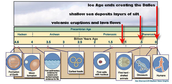
250 feet above the river. The formation of The Dalles began over 1
billion years ago when during Precambrian times ancient volcanoes
were active in this area. Keep also in mind that our continent was
not located then where it today due to massive continental shifts.
The Dalles as they appear today were formed as few as 10,000 years
ago as the St. Croix River drained an enormous glacial lake.
1.1 billion years ago, a series of volcanic
eruptions sent ten separate lava flows across the region at least
seven of which can be seen in the park. These lava flows hardened
into basalt which is typically a hard, black, often glassy,
volcanic rock. Here this rock can be seen as the steep cliffs along
the river.
Between 530 and 470 million years ago, the
region was covered by a shallow Silurian sea which deposited
sandstone and siltstone atop the basalt. The deposits accumulated
for millions of years.
10,000 years ago at the end of the last
glacial period the area was dramatically changed. As the glaciers
melted vast glacial lakes burst through their banks and carved the
St. Croix River Valley. When glacial Lake Duluth (whose banks once
stood 400 feet higher than present day Lake Superior) drained the
landscape was dramatically changed. The soft Cambrian sediments
which had accumulated for millions of years were eroded away in an
historical blink of an eye. As the basalt base was much more
resistant to erosion, the water was channeled into the St. Croix
Dalles which you now see as a deep, steep-walled gorge. This gorge
was created as the basalt which was fractured in angular patterns
during formation, chipped away. In addition to carving The Dalles,
the draining of glacial Lake Duluth left sediments that are up to
150 feet thick making the surrounding farmland some of the richest
in the world.
Potholes
The “potholes” you see in this park were formed as the glacial
flood raged throughout the area and great whirlpools were formed.
At times rocks would get caught at the bottom of these whirlpools
and cut into the basalt below it. Here they range in size from a
few inches to several feet in both depth and width. The grinding
stones often ended up as smooth ball shaped rocks left at the
bottom. It is thought that there are many more potholes hidden
under sediment in the area in addition to the approximately 80
known formations.

|
Eskers
Throughout the park you will notice graceful, winding hills. Many
of these formations are actually eskers. These formations were
created when sand and gravel was deposited by water that flowed
through tunnels at the base of the glacier as it melted. These
formations often look like railroad embankments. |
The Ice Age Trail
Here at Interstate Park is the beginning of the Ice Age National
Scenic Trail. The “IAT” is a thousand-mile footpath — entirely
within Wisconsin — that highlights Ice Age landscape features while
providing access to some of the state's most beautiful natural
areas.
You may have noticed some EarthCaches in Wisconsin
have the letters IATCC in front of the cache name. IATCC is
the acronym for the Ice Age Trail Cold Cache program. The
“ColdCache” program is based on finding EarthCaches along the Ice
Age Trail. In this program you can earn awards by finding special
EarthCaches branded with the IATCC designation.
For questions about any aspect of the ColdCache
program, visit the Ice Age Trail website at
http://www.iceagetrail.org/coldcache.htm or contact the program
coordinator at coldcache@iceagetrail.org.
|
Here is a list of
geological features all of which may be found along the Ice Age
Trail: |
|
Barrens: Areas where pine and stunted oaks grow .
. . barrens are found in prairie-like areas with sandy, infertile
soil. |
|
Bluff: A very steep hill . . . or small cliff,
frequently next to a river or ocean. |
|
Bog: A wetland . . . that accumulates acidic
peat, a deposit of dead plant material. |
|
Dalls / Dalles: A gorge . . . formed by torrents
of meltwater released by the melting glacier or draining glacial
lakes. Some dramatic examples; the Dells of Eau Claire, the
Wisconsin Dells, and The Dalles of the St Croix. |
|
Dolomite: A rock . . . similar to limestone
consisting largely of calcium magnesium carbonate. |
|
Drumlin: An elongated hill . . . formed from the
debris carried by the glacier and deposited as the glacier moved
along. These streamlined elongated hills show the direction the ice
was moving. |
|
Erratic: A boulder . . . that was carried long
distances by the glaciers, then deposited where the glacier
melted. |
|
Esker: A sinuous ridge . . . formed of rounded
sand and gravel deposited by the streams that flowed through
tunnels at the base of the glacier as it melted. |
|
Extinct Glacial Lake: A glacial lake that drained
. . . often catastrophically when a glacier or glacial lobe melted
back. |
|
Fen: Low, flat marshy land . . . where
decomposing plants accumulate, forming peat. |
|
Ford: A shallow place . . . in a river or stream
where one can cross by wading. |
|
Glen: A valley . . . typically one that is long,
deep, and often glacially U-shaped, or one with a water course
running through. |
|
Great Lake: Freshwater lake . . . that is part of
the chain that form the largest group of freshwater on
Earth. |
|
Hummocky: Hilly . . . knob and kettle
topography. |
|
Ice-Core Moraine: A moraine . . . that was formed
by the slow disintegration of large masses of ice that broke off
the main glacier and were buried by sand and rock still being
pushed south by the glacier. |
|
Ice-Walled-Lake Plains: Flat top mounds . . .
that were once the bottoms of lakes that lay in pits in the ice
sheet. When ice melted, the accumulated debris formed the
mounds. |
|
Kame: A conical hill . . . composed primarily of
water-rounded sand and cobbles. These deposits were formed by
streams that swirled downward through cracks in the
ice. |
|
Kettle / Kettle Lake: A surface depression . . .
formed by the melting of large blocks of glacial ice that were
buried in glacial till. As the ice melted, the moraine material
collapsed into the hole forming funnel shaped hollows. Kettles are
20 feet or more deep. |
|
Marsh: A wetland . . . which is subject to
frequent or continuous inundation (flooding). |
|
Meltwater Channel: A channel . . . formed by
abrasion as a result of sediment from a melting glacier; can be
under, along, or in front of an ice margin. |
|
Moraine: A ridge . . . formed by the gravel,
sand, and boulders carried along near the edge of the glacier and
deposited as the glacier melted back. Some are only 20-30 feet
high, while others in the Kettle Moraine area rise 250-300
feet. |
|
Mylonite: A type of rock . . . formed 2 billion
years ago by lava flowing to the earth’s crust. Over time, the rock
tilted to present near vertical position seen at the Dells of Eau
Claire. |
|
Niagara Escarpment: A ridge . . . which is a
transition zone between different physiogeographic provinces that
involves a sharp, steep elevation differential, characterized by a
cliff or steep slope. |
|
Outwash Plain: A sandy plain . . . formed when
glacial meltwater streams became braided (interconnected) and
spread smaller particle material such as sand, over a wide area.
They were deposited in both glaciated and unglaciated
areas. |
|
Pitted Outwash: An area of outwash dimpled with
kettles . . . formed by meltwater-carried blocks of ice that were
deposited with sand and gravel, and later melted in place, leaving
kettles. |
|
Pothole: A deep, cylindrical hole . . . formed
when water from the melting glacier swirled vortices that rotated
and vibrated “grinding stones” into rock. The grinding stone often
ends up as a smooth ball shaped rock left at the
bottom. |
|
Sedge Meadow: A wetland . . . that is dry in late
summer and composed mostly of sedges; plants that look like grasses
but feel rough when stroked. |
|
Spring: A natural water system . . . that
delivers water to the surface of the Earth. |
|
Swale: A hollow or depression . . . at the
beginning of a valley that often has wet soils. |
|
Tunnel channel: A valley . . . carved by a fast
moving river under a glacier. After the glacier has melted, the
valley often contains a series of lakes. |
~~~EARTHCACHE LOGGING
REQUIREMENTS~~~
(E-MAIL ME)
1. Where is the Eastern
Terminus of the IAT?
(E-MAIL ME)
2. Estimate the height
of the bluffs at the posted coordinates. Do you think the river is
still carving into the basalt? If so do you think the rate of
change has increased or decreased after the last Ice
Age?
(UPLOAD WITH YOUR FOUND-IT
LOG)
3. Upload a picture
showing another of the 30 features above taken somewhere along the
Ice Age Trail. While it is acceptable for you to select the eskers
or the potholes in this park, I encourage you to explore the IAT
and select another feature from the list. The location does not
have to be at a developed EarthCache or ColdCache location; you can
choose any spot along the Ice Age Trail which spotlights a glacial
feature.
A. Describe the feature.
B. List its coordinates.
The Geocache Notification Form has been submitted to Thomas A.
Meyer Conservation Biologist, State Natural Areas Program.
Geocaches placed on Wisconsin Department of Natural Resource
managed lands require permission by means of a notification
form.
References:
http://discovery.mnhs.org/MN150/index.php?title=Dalles_of_the_St._Croix_River
http://en.wikipedia.org/wiki/Esker
http://en.wikipedia.org/wiki/Interstate_Park
http://en.wikipedia.org/wiki/St._Croix_River_%28Wisconsin-Minnesota%29
http://www.iceagetrail.org/
http://science.nasa.gov/headlines/images/zircon/crystal_timeline00.jpg