Mining on the “Iron Ridge”
Wisconsin’s first Iron smelter
Please note that this is an EarthCache and as such logging this cache requires special tasks be performed. Those tasks are detailed below.
Within a distance of 5 miles are roads with names like Limestone Road, Limetown Coutry, Mine Road, Ore Road, Slag and Rock roads. What else could this mean but that this area has a mining history?
Local History:
Mayville was founded in 1845 by Alvin and William Foster and Chester May. A short time later the men discovered a deposit of red dirt about four miles south of Mayville in what is now Neda, Wisconsin (located at the intersection of Hwy 67 and 33). They suspected this might be evidence of iron ore so they began to mine this “Iron Ridge.” What the men found was found a vast supply of various grades of iron ore. In 1848 the state’s first iron smelting furnace was built nearby to process this ore. The industry prospered for about 80 years eventually producing 800 tons of iron per day (much of which came from upper Michigan, northern Wisconsin, and Minnesota). After the local mines produced thousands of tons of iron ore, processing ceased in 1928. The closing of the mine and smelter was due in part to the transition in industry from iron to steel and the increasing cost of rail freight. While the ore mining has ceased, limestone is still quarried in the area for use in construction.
Local Mines:
Over time as many as 5 mines were located along the Iron Ridge / Neda Iron District which runs between the towns of Iron Ridge and Mayville (just east along highway 67). These iron and limestone mines included pit, shaft, and drift mines.
 |
Pit mines:
In Southeastern Wisconsin Pit mines are fairly common. Also known as open-cut mining or strip mines, in this type of mining rock or minerals are removed from an open pit. Once abandoned they usually fill with water and often serve as a swimming hole for the community. One of the pit mines in the area was known as the "paint pit". While the ore from the paint pit mine was easily accessible, it was also of a low grade therefore the ore here was used for making paint pigment which was eventually used on barns and railroad cars. The "paint" mine closed in 1937.
|
Drift mines:
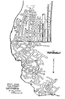
A drift mine is one which is cut into a hillside rather than tunneling downwards. Drift mines have horizontal entries and are usually dug at a slight incline so that the removal of material is easier due to gravity. Here the drift mine was dug into a limestone cliff of up to 65 feet in height. This map (left) shows the Neda drift mine’s tunnels. The estimated length of the mine tunnels is about 4 miles. The southern most tunnels are from the earliest period. This mine was opened in 1864 and closed in June of 1914. Today it is the hibernation area for between 150,000 and 300,000 thousand little brown bats, northern long-eared bats, eastern pipistrelles, and big brown bats
Shaft Mines:
Shaft mining refers to the method of digging a vertical or near-vertical tunnel from the top down. The shaft mine located here closed in 1928.
|
The Ore:
The iron ore here is a fine grained "seed ore" made of small flattened spheres about 1mm in diameter. Its composition is about 70% peroxide of iron giving it a metal content of about 50% iron. Trace elements of 4% aluminum, 3% magnesium, and other non-metallic elements are also found in the ore. This ore was easy to mine but at the same time made the tunnels very unstable. Here iron can be found under about 30 feet of limestone and the ores veins can range from a few grains to over 30 feet thick. The average thickness of the ore in the escarpment is 10 feet.
|
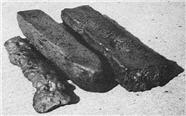 |
Once the ore was mined it was placed into a smelter (oven) where it was melted. Once in a liquid state it was poured into sand channels on the floor to cool, shape and be cut into Pig Iron ingots for shipment.
Area Geology:
The mines here are dug into an exposure of the Niagara Escarpment. The Niagara Escarpment, known locally as "The Ledge," is a steep bluff that separates two areas of differing elevation. The Escarpment’s exposure here is roughly 70 feet high and runs about 3.5 miles from just south of Mayville to the town of Neda.
The 650-mile long Niagara Escarpment is composed of a layer of bedrock made up of Silurian limestone and dolomites. The materials main ingredient was created from the decomposition of shells and skeletons of primitive sea life laid down about 400 million years ago when an ancient sea covered the area. For hundreds of millions of years the sediments grew deeper and heavier eventually causing the basin to sink in the middle. Over time the margins of this bedrock begin to spring back up at each end forming an escarpment which can be seen most dramatically in New York as Niagara Falls. During the last Ice age much of the escarpment was buried by glacial wash or worn flat making the viewable exposures few and far between.
*** LOGGING REQUIREMENTS ***
To log this EarthCache you will need to email me the answers to the 2 questions below.
1. From the above text: how is the drift mine being used today?
2. From the above text: What is still being mined here today?
Optional: Upload with your log a photo of the Escarpment taken somewhere near Neda. Please note the escarpments rock face is exposed in very few spots and those are best seen in winter. A picture of the tree covered ridge along Hwy 67 (near the intersection of Hwy 33 and up to 3 miles north) is fine.
Photos are the best way to thank an EarthCache developer and to encourage others to visit.
|
References:
|
|
http://www.mindat.org/loc-22542.html
|
|
http://www.seii.com/bats/mine/default.htm
|
|
http://www.burlingtonnews.net/theledge.html
|
|
http://midwest.fws.gov/horicon/hisgeolgy.html
|
|
http://news.cals.wisc.edu/newsDisplay.asp?id=295
|
|
http://www.wisconsinhistory.org/museum/artifacts/archives/003635.asp
|
Further information and original artifacts are on display in the "Iron Country" room at the Mayville Limestone School Museum, 215 N. Main Street, in Mayville, WI. The museum's website can be accessed at Mayville Limestone School Museum The museum is open to the public on the 1st and 3rd Sunday afternoons from 1:30 - 4:30 pm, beginning May 4 and ending October 19, 2003. For museum information, call: (9