Parking disponible au: N44°59.906',
E002°41.570'
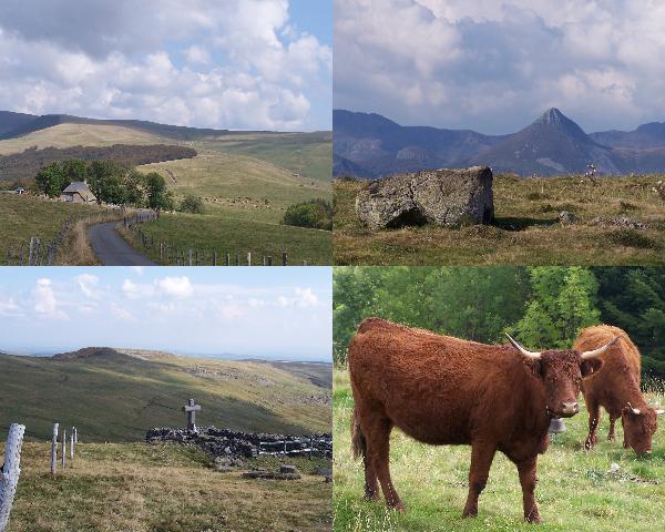
Du parking, continuer la route à pied. Après 300m, on arrive au
Buron de la Tuillière- ancien buron à fromage, converti en auberge
(mais toujours sans électricité!).
Le GR passe devant le buron, et il est repérable sans
difficulté. Continuer sur cette piste, ancienne voie romaine,
jusqu'à la cache, à 1,6km du parking. Vous pouvez admirer le
paysage avant de retourner au buron manger un casse-croute si
l'envie vous dit...
Pour les plus courageux, poursuivez jusqu'à la Chapelle du
Cantal (à 4,3km du parking), à proximité du sommet du Puy Gros
(1594m). Cette chapelle, construite en 1687 servait aux offices des
vachers et bergers qui passaient l'estive dans les burons. Elle est
maintenant en ruines, mais une croix à été érigée au milieu des
pierres en commémoration. La ballade entre la cache et la chapelle
donne des points de vue spéctaculaires sur tous les monts du Cantal
et la vallée de la Cère.
S'assurer que le temps n'est pas orageux. Attention à ne pas
déranger les vaches (jolies mais cornues!).
Contenu initial de la boîte: Logbook,
(& crayon, taille-crayon, notices), boîte à 'émeraudes',
autocollants Tweenies, figurine nounours, décoration sapin de Noël,
escargot de course, coeurs en bois autocollants, porte-clé
salamandre, Geocoin Tortue, 'Rainbow Sock' TB.
Car park available : N44°59.906',
E002°41.570'
From the car park, carry on down the road. After around 300m,
you arrive at the ‘Buron de la Tuillière’, an old
cottage used to make and stock Cantal cheese. It’s now been
turned into a café, although there’s still no electricity! Go
on past the buron, the GR trail (an old Roman road at this point)
is easy to follow. The cache is situated at 1.6 kms from the car
park. Stop and admire the mountains before heading back for
pancakes at the café…
If you’re feeling brave enough, carry on along the trail
until you reach the Chapelle du Cantal (4.3 kms from the car park),
near the top of the Puy Gros peak, situated at 1594 metres
altitude. The chapel was built in 1687, and services were held here
for shepherds and herdsmen who spent the summer period in the
mountains looking after their animals and making cheese. The chapel
is now in ruins, but a cross has been put up in commemoration. The
walk between the cache and the chapel gives great viewpoints of the
Cantal mountains and the Cère valley. You’ll also go through
some lovely picnic-perfect meadows…..
Check to make sure the weather won’t be stormy. Be careful
not to disturb the cows- the Salers have pretty mahogany coats, but
long horns!
Initial contents of the box: Logbook
(& pencil, sharpener, Geocaching leaflets), box of 'emeralds',
Tweenies stickers, teddy bear figure, Christmas tree decoration,
racing snail, wooden hearts stickers, salamander keyring, Turtle
Geocoin, Rainbow Sock Travel Bug