One of the huge radar antenna towers
History of the
Station
The US Air Force built the North Concord Radar Station on top of
3,400 foot East Mountain in 1955. Its name was changed to
Lyndonville Airforce Station in 1962 and before the largest antenna
tower was even completed, the base closed in 1963. The station was
to provide surveillance of the St. Lawrence River Valley in case
Soviet bombers were to penetrate US territory.
In 1961 the station reported a UFO sighting that lasted roughly
eighteen minutes and a few hours before the alleged abduction of
Barney and Betty Hill that was made famous by a book and later by a
TV movie starring James Earl Jones and Estelle Parsons in
1975.
The Station is located on a 17 acre summit parcel (probably chopped
off the top of the mountain) and is accessed via a seven mile road.
A few miles below the summit parcel is the 30 acre cantonment,
which served as the base camp for the military personnel stationed
at the radar antenna facility.
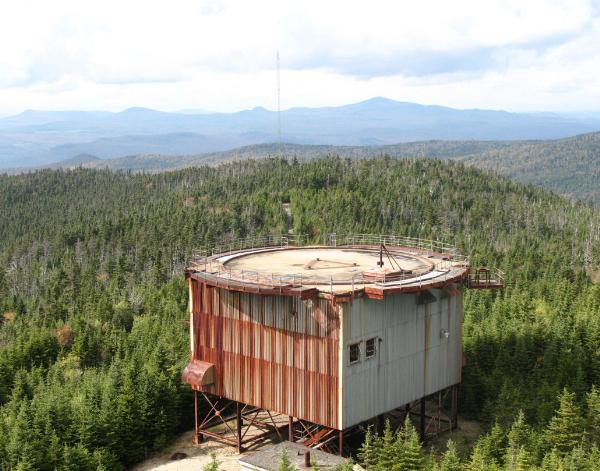
The radar antenna site contains the remnants of 5 huge towers
ranging in height from 40 to 90 feet tall, plus a few ancillary
storage buildings. The radar towers originally supported white
inflatable domes that protected the radar antennas inside, with the
exception of the tallest central tower that was never finished
prior to the close of the facility.
Since around 2003 there have been studies performed and proposals
for wind turbines to be installed at the old station by the East
Haven Wind Farm. But as of today, there is still only one
experimental 'data collecting' tower on top of the mountain.
What We
Found
This was truly a great adventure. We came in from Radar Road in
Victory and drove to the gate at N: 44deg 38.001 W: 071deg 48.661.
We brought our bikes and began our ride up the mountain. The road
from the gate to the lower 'village' was pretty torn up but
navigable with a mountain bike. From the lower village to the top
of the mountain the road is in incredibly good shape for a road
that was built and paved 50 years ago! The distance from the
parking to the cache is approx. 4.5 miles one way. And yes, there
are a couple of sections where we pushed our bikes. But coming down
made it all worth it!
When we arrived at the radar station it was kind of like one of
those movies where you come out of hiding for decades only to find
skeletons of buildings with vegetation growing here and there
through the pavement and around the dilapidated buildings.
But then the fun began. Although there isn't much left of the
buildings, we took time to explore them all, mostly from the
outside as they have been pretty well boarded up to keep people
out. Since the construction took place back in the 50's there are
asbestos warnings in the area. We spent a good 2 hours exploring
the area, it was really pretty cool.
About The
Cache
When we finished exploring we placed a cache. You are looking for a
square lock-n-lock. It is placed winter friendly and you do NOT
have to climb anything (except the mountain) and you don't have to
enter any of the buildings to get to the cache.
This was a great adventure and we hope to return, preferably in the
winter so we can try out sledding down the mountain after we check
out the winter views!
Have fun and be safe!
 QSeekers