Cabin Creek Falls - Grayson Highlands Style EarthCache
Cabin Creek Falls - Grayson Highlands Style
-
Difficulty:
-

-
Terrain:
-

Size:  (not chosen)
Please note Use of geocaching.com services is subject to the terms and conditions
in our disclaimer.
Go to the beautiful Grayson Highlands Park. Park at the
Massie Gap parking area and find the trail head (see sign) and
enjoy the .7-mile hike to the Falls. Gradual downhill but alas,
it’s uphill on the return!
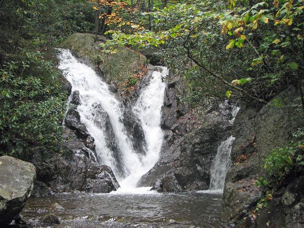
The Cabin Creek
Falls
The Appalachian Mountain range is old. The formation of the
mountains is estimated to have begun 680 million years ago during
the Paleozoic Era. In an event called the Alleghanian Orogeny, the
ocean crust was subducted beneath the continent that would later
(much later) be named North America. This made the later named
Africa drift closer to North America. The continents continued to
drift until they collided. The ‘super collision’ caused
the land to fold upward thus creating the Appalachian Mountains.
The mountains are made mostly, but not all, of sedimentary rock. An
exceptional part of the mountain forming can be found here at the
Mount Rogers. Volcanoes formed these mountains!
.
With some exceptions, here in Virginia and in most parts of
the Southern section of the Appalachian Mountains, the rock
outcroppings are mostly sedimentary with some few being igneous
rock. Sediments that are consolidated and accumulated in layers as
the name implies form sedimentary rocks. Here at the Cabin Creek
Falls, the rock that the Creek flows over is a combination of
basalt and rhylolite. These rocks are far different than the
‘typical’ sedimentary base rock of most Appalachian
waterfalls. Since magma, which forms igneous rock and in turn
formed the Mount Rogers Mountains. Cabin Creek Falls have
had their work cut out for them. Since sedimentary rock is much
softer than igneous rock, far less wear or erosion takes place
resulting in less of an undercut. Yes, in case you didn’t
catch it, volcanoes formed these mountains of the Mount Rogers
Formation and that’s where the igneous rock came from! The
Cabin Creek Falls ‘cling’ to this igneous base
rock resulting in little to no undercut.
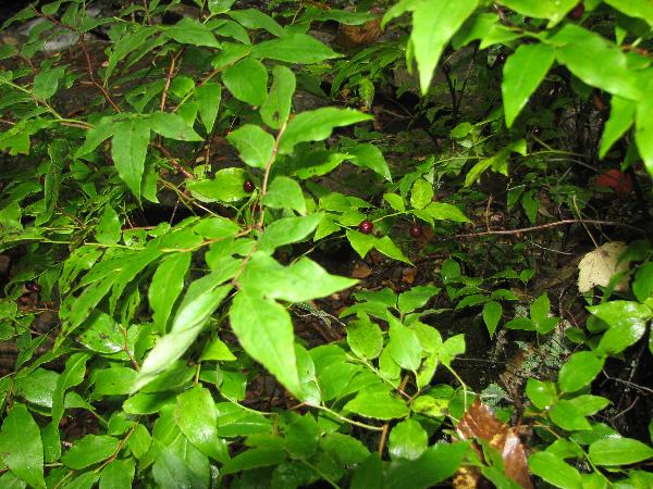
Nearby Blurberry
Bush
The Cabin Creek has its origin high up in a hollow between
the Wilburn and Cabin Creek Ridges. Along its way to join the
Middle Fork of the Hilton to form Helton Creek, Cabin Creek tumbles
over a beautiful base rock to form the Cabin Creek Falls.
Because of its ‘style’ (type), which you will name
later, the Cabin Creek Falls are known as one of the most
beautiful falls in the Mount Rogers area! The Cabin Creek, now the
Hilton Creek flows into the North Fork of the New River, which
eventually becomes the New River. The New River is considered to be
one of the oldest rivers in the World!
There are several types of
Waterfalls:
PLUNGE: the water descends vertically, losing contact with
the bedrock surface
Horsetail: The descending water maintains some contact with
bedrock
FAN: water spreads horizonally as it desends while remaining
in contact with bedrock
PUNCHBOWL: water descends in a constricted form, then
spreads out in a wider pool
BLOCK: the water descends from a relatively wide stream or
river
TIERED: the water drops in a series of distinct steps or
falls
SEGMENTED: separate (distinctly) flows of water form as it
descends
RAPIDS: Slow desent in steps, clings to base rocks
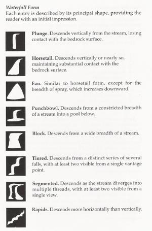
Of These Types, Which One Am
I?
Note In order to receive credit for the
Earthcacheyou must do the following:
1. Email us the answers to the following:
A. Estimate the height of the waterfall (within +/-
10feet)
B. Estimate the width of the waterfall (within +/-
10feet)
C. Using the above classification, what type of waterfall is
the Cabin Creek Falls?
2. Upload a picture while pointing your GPSr at the Falls.
While it would be nice, it is not necessary to show your face in
the picture.
Thanks for visiting our EarthCache. We hope you learned a
little bit about waterfalls and had as much fun with your visit as
Marge and I did finding the Falls.
This Earthcache was approved by the
Geological Society of America
| We have earned GSA's highest level: |
 |
Additional Hints
(Decrypt)
"Cyrnfr uryc zr, V'z Snyyva', snyyva' sbe lbh!"
Treasures
You'll collect a digital Treasure from one of these collections when you find and log this geocache:

Loading Treasures