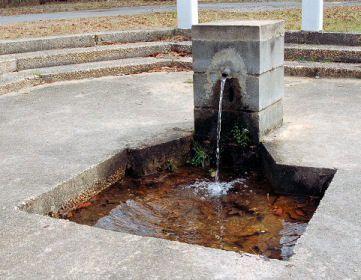
Blenheim Mineral Spring History
This spring was discovered purely by happenstance in 1781 while
James Spears, a local Patriot, was running from loyalist. He lost
his shoe in the chase. He eluded those chasing him and returned to
the site to retrieve his shoe. He drank from the springs and found
the water quite refreshing. Word spread of the local springs and
the good quality of water it produced. Dr May, a local doctor,
invented a concoction for stomach ailments using the water and
other ingredients. This would later become known as Blenheim Ginger
Ale.
Blenheim Ginger Ale: So what is it?
Blenheim Ginger Ale is a ginger ale bottled by Blenheim Bottlers
in Hamer, Dillon County, South Carolina. It was originally bottled
in Blenheim, Marlboro County, South Carolina. It was created by a
local doctor in 1903 by mixing Jamaican ginger with the local
mineral waters since the flavor of the mineral waters was so
strong.
So what is a Spring ?
A spring is a water resource formed when the side of a hill, a
valley bottom or other excavation intersects a flowing body of
ground water at or below the local water table, below which the
subsurface material is saturated with water. A spring is the result
of an aquifer being filled to the point that the water overflows
onto the land surface. They range in size from intermittent seeps,
which flow only after much rain, to huge pools flowing hundreds of
millions of gallons daily.
How are springs formed?
Springs may be formed in any sort of rock. Small ones are found
in many places. In Missouri, the largest springs are formed in
limestone and dolomite in the karst topography of the Ozarks. Both
dolomite and limestone fracture relatively easily. When weak
carbonic acid (formed by rainwater percolating through organic
matter in the soil) enters these fractures it dissolves bedrock.
When it reaches a horizontal crack or a layer of non-dissolving
rock such as sandstone or shale, it begins to cut sideways, forming
an underground stream. As the process continues, the water hollows
out more rock, eventually admitting an airspace, at which point the
spring stream can be considered a cave. This process is supposed to
take tens to hundreds of thousands of years to complete.
Water flow from Blenheim Mineral Spring
The amount of water that flows from springs depends on many
factors, including the size of the caverns within the rocks, the
water pressure in the aquifer, the size of the spring basin, and
the amount of rainfall. Human activities also can influence the
volume of water that discharges from a spring—ground-water
withdrawals in an area can reduce the pressure in an aquifer,
causing water levels in the aquifer system to drop and ultimately
decreasing the flow from the spring.
Why is Blenheim Mineral Spring Drinkable?
The quality of the water in the local ground-water system will
generally determine the quality of spring water. The quality of
water discharged by springs can vary greatly because of factors
such as the quality of the water that recharges the aquifer and the
type of rocks with which the ground water is in contact. The rate
of flow and the length of the flowpath through the aquifer affects
the amount of time the water is in contact with the rock, and thus,
the amount of minerals that the water can dissolve. The quality of
the water also can be affected by the mixing of freshwater with
pockets of ancient seawater in the aquifer or with modern seawater
along an ocean coast.
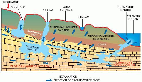
Ground-Water Flow in the Coastal Plain Aquifers of South
Carolina
Walter R. Aucott is a Hydrologist with the U.S. Geological
Survey in Columbia, South Carolina where he has been conducting a
Regional Aquifer Systems Analysis (RASA) project on the
southeastern Coastal Plain aquifer system in South Carolina.Gary K.
Speiran is a Hydrologist with the U.S. Geological Survey in
Columbia, South Carolina where he has been assisting in the RASA
project. He also has been the District Water-Quality Specialist
(Acting) and has been conducting and assisting in several other
projects.
What they found out
The characteristics of the Coastal Plain aquifers of South
Carolina are being studied as a part of the Regional Aquifer System
Analysis program of the United States Geological Survey.
Potentiometric maps were constructed for the Middendorf aquifer of
Cretaceous age and for the Floridan aquifer system and its sand
facies equivalent, Tertiary sand aquifer, prior to development.The
Coastal Plain aquifers are recharged primarily by precipitation in
their outcrop areas. Ground water flows from these areas of
recharge, through the aquifers, and discharges to upper Coastal
Plain rivers, overlying aquifers as upward leakage, and wells.
Ground-water flow in the Floridan aquifer system and the
Tertiary sand aquifer prior to development is generally
perpendicular to the coast. Predevelopment flow in the Cretaceous
aquifers, however, turns northeastward as it approaches the coast,
almost paralleling the coast. The change in flow direction is
caused by less effective intervening confining units, the aquifers
being closer to the land surface, and the rivers at lower altitudes
farther upstream in the vicinity of the North Carolina/South
Carolina State line.
Water-level declines in the Cretaceous aquifers have occurred
throughout much of the eastern part of the Coastal Plain of South
Carolina due to pumpage in the Myrtle Beach and Florence areas.
Large areally extensive water-level declines have also occurred in
the Floridan aquifer system in South Carolina due to pumpage in the
Savannah, Georgia area.

So how do I get credit for this Earthcache?
1.) Take a photo of you and your gps at the spring.
2.) Estimate how fast the water is flowing from the spring?
3.) Is the spring drinkable today?
4.) Which underground aquifer is being used by the spring?