Mpakeni’s
Granite Pluton
About 20km east from Nelspruit on the N4 you’ll find the
Crocodile River Gorge. This gorge cuts trough the mountain for
nearly 10km on the way to Komatipoort and illustrates the nature of
the granodiorite gneisses and migmatites of the Nelspruit
Suite.
This mountain is known as the Mpageni Granite Pluton. It intruded
through the Nelspruit granite batholith about 2740 million years
ago and now forms part of the Nelspruit Granite Suite (see the
EarthCache ).

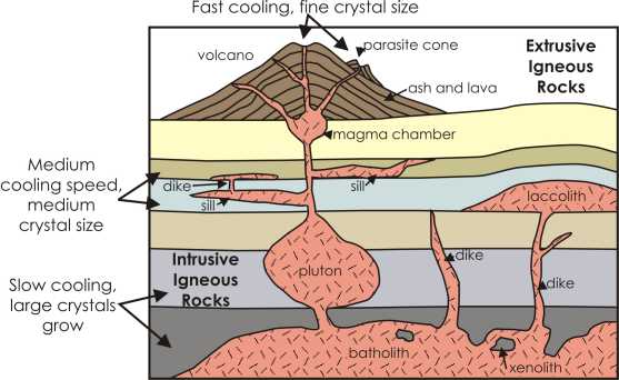
A pluton in geology is an intrusive igneous rock body
that crystallized from magma slowly cooling below the surface of
the Earth. Plutons include batholiths, dikes, sills, laccoliths,
lopoliths, and other igneous bodies. In practice, "pluton" usually
refers to a distinctive mass of igneous rock, typically kilometers
in dimension, without a tabular shape like those of dikes and
sills. Batholiths commonly are aggregations of plutons. The most
common rock types in plutons are granite, granodiorite, tonalite,
and quartz diorite.
A pluton is a general term that can be
applied to any intrusive igneous body regardless of its
composition, shape, or size.
The term originated from Pluto, the ancient Roman god of
the underworld. The use of the name and concept goes back to the
beginnings of the science of geology in the late 1700s and the then
hotly debated theories of Neptunism, Volcanism and Platonism
regarding the origin of basalt.
Sources:
Geoscience
Wikipedia
Note: Although this place is locally known as
Mpakeni (derived from the Mpakeni tribe), most of the
geological resources referred to it as the Mpageni
pluton.
The northern part of the pluton contains mostly the
Mthethomusha Game Reserve on the land owned by the adjacent Luphisi
and Mpakeni communities, which they have leased to the Mpumalanga
Parks Board. (see Link
and Link for
information and directions).
The southern part of the pluton contains the
Krokodilpoort Nature Conservancy which contains agricultural and
game farms. Taking the Mara turnoff on the western side of the
gorge will also take you to other caches which include the great
Extreme Contrasts cache
Link at the Mpakeni peak, from where you will have a
magnificent view over the Mpakeni Pluton and down onto the
river
Parking in the gorge are limited next to the road. The
co-ordinates show the best place for a quick stop and also the best
view of the peak but there might also be a few muggles. This is
also a busy road sometimes and care must be taken when pulling off
the road and on re-entering the traffic.
To log your find, answer the following questions and
email them to me (do not post the answers in your log):
1. What is the difference between a pluton, a diapir and a
laccolith?
2. Take a nearby look at the rocks (when parked at a save place).
What is the color of the granite?
3. What is the approximate distance (up to the nearest 300meters)
from the KaNyamazane turnoff to the Matsulu turnoff when driving on
the N4 road through the gorge? This is roughly the width of the
pluton.
Uploading photos to the cache page is the best way to say thank
you to the cache developer and to encourage others to visit the
location but is only optional.
You can send your answers to me in either Afrikaans or
English.
You can also do the cache from Extreme Contrasts!