WARNING:- RISK ASSESS CAREFULLY BEFORE YOU UNDERTAKE THIS WALK
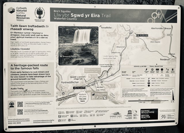
The earth-cache is situated in ‘Waterfall Country’ in a triangle formed by the villages of Hirwaun, Ystradfellte, and Pontneddfechan. Waterfall Country includes the head waters of the rivers Nedd, Mellte, Pyrddin and Hepste. These rivers drain the old red sandstone mountain ranges of the Fan’s in the north and travel south through the deep V shaped wooded valleys the rivers have formed in the carboniferous limestone of the southern belt of the national park.
These interlinking complex systems of rock formation are the bedrock of the landscape we know as the Brecon Beacons National Park. Over geological time various factors and forces served to shape this underlying bedrock into the landscape we see.
The central feature of the Brecon Beacons are the mountain ranges that extend across the full width of the National Park. The National Park is divided into three distinct collections of mountain escarpments named the Black Mountains (eastern side); the Brecon Beacons (the central area) and sometimes confusingly in the singular the Black Mountain or Carmarthen Fan (Western area).
The geology of most of the Brecon Beacons National Park consists of old Red Sandstone a sedimentary rock laid down more than 300 million years ago. Confusingly, Old Red Sandstone is not always red, though the underlying presence of its rich reddish hue is often a backcloth beneath the green vegetation in more than two thirds of the 519 sq miles of the National Parks area.
In this old red sandstone geological system has a number of subdivisions including red marls (a deep rich red colour) , Senni beds (greenish hue), Brownstones, Plateau beds, and Grey Grits. Old Red Sandstone may therefore be thought of as a generic term.
The brownstones are the building blocks of the main mountain ridges. However, the distinctive billiard table summits of mountain peaks in the Brecon Beacons such as Pen Y Fan, Corn Ddu Fan Hir and Fan Gyhirych are topped by "plateau beds". Plateau beds are tough gritty sandstones with occasional quartz pebbles and form a resilient capping
In the southern half of the Brecon Beacons National Park, due south of the small village of Ystradfellte, there lies an area of Carboniferous Limestone and Millstone Grit containing steep sided gorges, cave systems and numerous spectacular waterfalls.
In stark contrast to the old red sandstone geological system the southern zone of the national Park consists of a Carboniferous limestone system that extends from the far west to the southernmost tip in the east. Limestone country is easy to recognize it is consistently grey in stark contrast to the reds and browns of the predominant old red sandstone.
This southern edge of the Brecon Beacons National Park the belt of carboniferous limestone wedged between Old Red Sandstone to the north and the Millstone Grit containing coal deposits to the south.
One of the characteristics of carboniferous limestone is that it is susceptible to the action of slightly acidic water. Rain falling in this locality absorbs carbon monoxide from the air thus creating a mild solution of carbonic acid. As this slightly acidic water passes through the naturally occurring cracks and fissures in the carboniferous limestone over geological time it has created the extensive cave systems found along this southern edge of the Brecon Beacons National Park.
The coal measures of such significance in the history of South Wales and one of the building blocks of the Industrial Revolution, are only found in a few small areas within the National Park. Within the carboniferous system on the southern edge of the National Park can be found Millstone Grit. Sometimes referred to as Farewell Rock so called because once a coal miner encountered this rock no coal is found worth working beyond this strata. It is popular with climbers and has been used for the hearths of iron furnaces being resistant to intense heat.
In South Wales, and the Vale of Neath in particular, the typical cause of waterfall formation is due to differential erosion of soft and hard rock strata found together in the river bed. Where historic movements in the earth's crust has caused faulting, or glacial erosion has exposed the softer underlying rock strata to the erosive forces of the river, it will cut more deeply and quickly into the softer rock creating a drop in the water level and, consequently, boosting the erosive power of the water.
Waterfalls occur at places in the river where the topography or height changes. Water runs over a ledge and falls usually vertically to the next level of the river. The ledges are usually made of a more resistant bedrock layer, different from the rest of the river's parent material. The water running over the ledge cuts into the rock under the ledge producing the falls and grade to the waterfall. Eventually the erosional forces will undermine the ledge and cause it the break off. This is what causes the upstream retreat of a waterfall. As this action continues, eventually after many years, the waterfall will disappear leaving only rapids as the trace it ever existed.
In this valley there are extremely hard, erosion resistant rocks such a millstone grit and old red sandstone overlying bands of softer fissured carboniferous limestone and fossiliferous shales. When the water finds its way through the joints and along the bedding planes of the harder rock exposing the shales and limestone, the water soon begins to take its toll on the softer rocks and so depriving the harder rocks of support, and ultimately causing them to collapse.
Often, the rock stratum just below the more resistant shelf will be of a softer type, meaning that undercutting due to splashback will occur here to form a shallow cave-like formation known as a rock shelter or plunge pool under and behind the waterfall. Eventually, the outcropping, more resistant cap rock will collapse under pressure to add blocks of rock to the base of the waterfall. These blocks of rock are then broken down into smaller boulders by attrition as they collide with each other.
Waterfall formation.
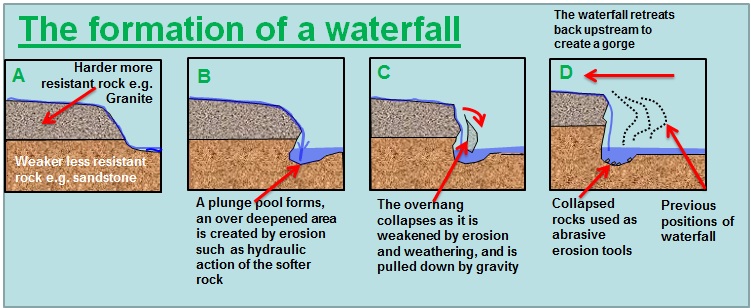
(NB Local rocks are not granite, as in the illustration, but the principle is the same),
The rock that you see in front of you has been washed in by a river (fluvial) and is mainly composed of sediment which is quartz sand (arenaceous) . You can see the grains clearly, The underlying rocks are mudstone which is made up of tiny clay particles (less than 0.05mm) that can’t be seen with the naked eye. These tiny particles are deposited in quiet low-energy environments like tidal flats, shallow lakes, etc. (HINT Q.4)
Streams become wider and shallower just above waterfalls due to flowing over the rock shelf, and there is usually a deep pool just below the waterfall because of the kinetic energy of the water hitting the bottom. Scwd yr Eira is one of the few falls where people can walk behind the water as it cascades down into a pool.
Although Scwd yr Eira Waterfall attracts 160,000 visitors a year it is an exceptionally hazardous walk. There are many approaches, as this is ‘classic walk’ of about 4 miles. Good walking boots are advisable as the path can be extremely treacherous in parts.
To claim this earth cache.
Please EMAIL me the answers ~ From the guidelines: You do not need to wait for permission to log. Requiring someone to wait is not supported by the EarthCache guidelines. You should send your logging task answers , then log the Earth Cache.
IF YOU DONT SEND A RESPONSE TO THE LOGGING REQUIREMENTS YOUR LOG WILL BE DELETED WITHOUT NOTICE.
Don't include the answers in your log even in an encrypted form.
WARNING:- BEFORE you proceed, look for any hazard signs there. Pay CLOSE attention!
1. Describe the weather conditions before and during your visit.
2. Estimate the size of the ‘rock shelter’ height / width / depth
3. Speculate on the difference between rocks the left hand side and underneath as you face the falls, and the rocks at the top. Don't worry about trying to identify them.
4. How has the nature of these rocks caused this feature?
5. THEN upload a picture, including you or a personal item, no giveaways though, and log the earth cache.
INDIVIDUAL RESPONSES ARE REQUIRED NO GROUP RESPONSES PLEASE!

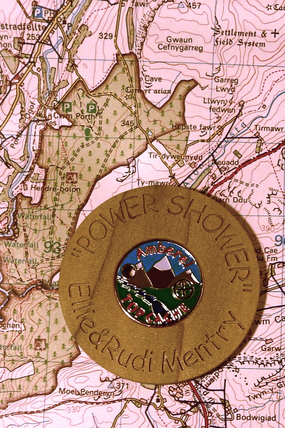
When you complete the logging requirements I will send you the tracking number of this lovely "Top Cache" tulip wood geocoin, for you to "discover". It was kindly made and given to me by "Amberel"