The coordinates will take you to the side of the public roadway with a good view (currently) of the Kosse coal mine. As of 11/1/2010 - you'll have to go to the East a bit as that's the direction the mining is progressing. There is no need to go onto any private property - everything you need can be obtained from this location. You don't even need to get out of your car!
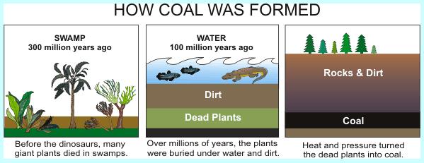
Coal is a brownish-black sedimentary rock that is normally found in layers or veins called coal beds. Plants growing in swampy areas provide yearly layers of plant material that, over time, accumulate. Because they remain under water and mud they are kept from fully decaying and their carbon material is preserved. Over time the plant materials were changed by geological action to create a solid material - coal.
Coal, a solid hydrocarbon, is a sedimentary rock, but the harder forms, such as anthracite coal, can be regarded as metamorphic rocks because of later exposure to elevated temperature and pressure. Coal is composed primarily of carbon, with various other elements, including sulfur, hydrogen, oxygen, and nitrogen.
There are several grades of coal. Without getting into the sub-specifics, there are three main categories: lignite, bituminous, and anthracite, ranked based upon their heat energy potential. Higher ranked coal contains more concentrated carbon than lower ranked coal. The evolution of coal is as follows:
* Peat - an accumulation of partially decayed vegetation.
* Lignite - sometimes referred to as brown coal, has characteristics between that of peat and coal.
* Bituminous coal - a soft coal containing a tar-like substance called bitumen. A mid-level coal, it’s regarded as being better than lignite, but not as good as anthracite.
* Anthracite - a hard, compact, coal. It is shiny, and has the highest carbon content and the fewest impurities.
Coal is a fossil fuel. It is the largest source of fuel used to generate electricity in the world. Coal powers about 40% of electricity generation worldwide, and about 50% in the United States. The United States has about 27% of the world’s coal reserves. Texas is the 5th largest producer of coal in the United States.
Energy from coal can be produced much more economically than from other fossil fuels. Its main drawback is that burning it produces large quantities sulfur, mercury and carbon dioxide (more than petroleum, and about double that of natural gas) -- the greenhouse gas responsible for global warming. Coal is extracted from the ground by either in underground mines or in open pits, depending upon how deep the coal is located from the surface.
Lignite has characteristics of both peat and coal. It’s considered the lowest grade of coal, and is almost exclusively used as a fuel for power generation. Lignite is geologically younger than the other forms of coal, mainly originating in the Tertiary period (~ 65 million to 2.5 million years ago).
It is brownish-black in color, and has a carbon content of 25% - 35%. Lignite often has a high content of volatile materials and a high moisture content. Because of spontaneous combustion issues, transportation and storage issues become problematic. Because of its low energy characteristics, it is not cost effective to transport long distances, and is often burned in power stations located close to the mine.
The coordinates take you to the roadside with a view of the Kosse mine. If you travel farther to the west, you will see the rail lines and the loading facility. The mine is expected to produce several hundred million tons of coal over three to four decades, at the rate of about 25,000 tons per day (about 9.2 million tons per year).
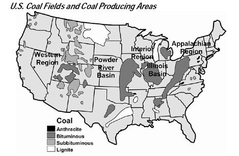
If you look at the map, above, of coal producing regions, you will see the white band (representing lignite deposits) across a potion of Texas. Kosse mine is in that zone. The curve of the lignite band represents the position of the shores and shallow inland regions of the Gulf of Mexico shortly after the Gulf opened up when North America split away from South America. Since that time, erosion has carried sand, clay, and other sediment from farther inland on the continent and continuously deposited it into the Gulf, filling it in and extending the continent to make today's shoreline.
At the time when the shore was where the current lignite band is shown, plant material near the shore and inland in marshy areas was deposited around the edge of the Gulf. The area was swampy in between river drainages. Similar conditions can currently be found on a drive from Houston to Galveston. Over time, erosion inland on the continent allowed sediments to be carried toward the Gulf. The shoreline extended further and further South, and sediment eventually also covered the peat. Eventually, the peat turned into lignite as part of the evolution of coal. That lignite is what is currently being mined in Kosse. 50 million years from now, there may be a similar lignite band between Houston and Galveston.
To get credit for this EarthCache:
1. You should post a photo of yourself (or hold up your GPSr) with a view of the mine in the background. Feel free to post lots of photos! I can't make you under the new rules, but please post a photo. Don't send them to me in the message system -- POST THEM!!
2. Send me an e-mail and answer the following questions:
a. Is this a surface mine or underground mine?
b. How tall do you think the walking dragline (crane for us laypeople) is? And how did you guesstimate it?
c. How deep below the surface does the coal appear to be at the end closest to the road and at the farthest point from the road? In other words, how much sediment, or overburden, is on top of the layer of coal at each point?
d. Bonus question: Where does the coal go to once it’s on the trains?
Additional Resources:
See info on the big digger HERE.
See the dragline walk across the road HERE.
Congrats to Kirbydox, Fendmar, and Nov64 for FTF!