
Gesteinsarten:
Die Gesteinsarten der Ziegeleigrube Dörfles Esbach bestehen aus Schilfsandstein und Lehrbergschichten der Hassberge-Formation (früher Kieselsandstein, Kieselsandstein-Schichten, Blasensandstein i.w.S., Coburger Sandstein). Sie ist eine lithostratigraphische Formation des Keupers in der Germanischen Trias. Sie wird von der Steigerwald- und der Mainhardt-Formation überlagert. Dieser Fazierstyp ist im Coburger Raum einmalig. mehr Informationen
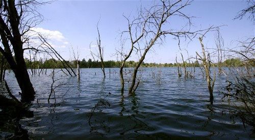
Es handelt sich um eine abgelegene, künstliche Lehm-, Ton-, Mergelgrube. Sie ist nicht mehr genutzt, der Zustand stark beeinträchtigt und als geschützer Landschaftsbestandteil eingestuft. Das lokal bedeutende Geotop ist ein Exkursions-, Forschungs- und Lehrobjekt.
Ton ist einer der Hauptbestandteile von Lehm und bezeichnet ein natürlich vorkommendes Material, das sich überwiegend aus feinkörnigen Mineralen zusammensetzt. Bei entsprechenden Wassergehalten ist Ton plastisch. Beim Trocknen oder Brennen z.B. in einem Brennofen härtet Ton aus. Belegt ist die Nutzung des als Rohstoff für Töpferwaren und Keramik bis in das Jungpaläolithikum hinein. Studien belegen sogar, dass einige Vorkommen eisenreicher Tone eine bakterientötende Wirkung haben. Innenauskleidungen von Öfen werden auch aus Ton hergestellt, die sog. Schamottsteine halten hohe Temperaturen stand und werden in der Stahl- und Glasindustrie eingesetzt. Natürlich wird Ton auch in Form von Ziegeln als Baumaterial eingesetzt. Formationen von hochdichtem Ton werden als Endlager für radioaktive Abfälle diskutiert.
Nutzung:
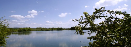
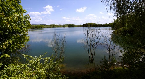
Seit Ende 1900 wurde, wo jetzt der Esbacher See aus Oberflächenwasser entstanden ist, Ton abgebaut. Es wurden Backsteine, Hohlsteine, Rinnen-, Taschen-, Firstziegel und Herdplatten "sowie andere Ware“ aus dem Rostoff hergestellt.
Die Produktion und der Lehmabbau wurde 1986 eingestellt und die Gesellschaft aufgelöst. Heute ist dort ein Naherholungsgebiet entstanden, das zum spazieren und verweilen einlädt.
Fragen zu beantworten:
Frage 1:
Das Gebiet dient heute auch als Laichgewässer für den Wasserfrosch und die ...?
Frage 2:
Wieviele Vogelarten können am Esbacher See mindestens beobachtet werden?
Frage 3:
Begieb dich zu Waypoint 2, von dort hast du einen Blick in Richtung Norden auf die Erde die hier abgebaut wurde. Schätze wie hoch in Metern die Abbruchkante vom Wasserspiegel aus ist.
Bitte fotografiere dich oder dein GPS am Esbacher See.
(bitte Tafel nicht leserlich abbilden, Das Foto ist keine Logbedingung)
Bitte sende mir die Antworten und einen kleinen Aufsatz zu den Gesteinsarten an GC22A3D@geocaching-oberfranken.de und logge den Cache als gefunden, sollte etwas nicht passen, werde ich mich melden.
Geology:
The rock types of the Ziegeleigrube Dörfles Esbach consists of Schilfsandstein and Lehrberg-layers of the Hassberge-Formation. It is a lithostratigraphic formation of the Keuper in the Germanic Triassic. It is overlain by the Steigerwald and the Mainhardt formation. This Fazierstyp is unique in the Coburg area. more Information
Clay is a naturally occurring material composed primarily of fine-grained minerals, which show plasticity through a variable range of water content, and which can be hardened when dried or fired. Clay minerals are typically formed over long periods of time by the gradual chemical weathering of rocks, usually silicate-bearing, by low concentrations of carbonic acid and other diluted solvents. These solvents, usually acidic, migrate through the weathering rock after leaching through upper weathered layers. In addition to the weathering process, some clay minerals are formed by hydrothermal activity. (By wikipedia)
Use:
Since the End of the 19th centuryin this area was clay mined. There were bricks, hollow bricks, gutters, pocket, ridge tiles and hot plates "and other goods" produced from the clay. The production was discontinued in 1986. Now there is a new peace of nature arose. Please take a while and enjoy the silence and the nature.
Questions to answer:
Question 1:
The area now serves as a spawning ground for the Water frog and (Wasserfrosch und) ... ?
Question 2:
How many different Birds can you see at least at the lake?
Question 3:
Go to Waypoint 2, there you can see the earth which was used for bricks far ago. Guess how high the earth from the drip line to the water is (meters).
Please photograph yourself or your GPS at the Esbacher See. (Not required for logging)
Please send me the Answers and a short text about the Nature there to GC22A3D@geocaching-oberfranken.de
(partly translated by google)

As the geocache owner, I ensure that this links to a local geocaching group that is active in the community and contributing to geocaching in positive ways. This link has not been checked by Geocaching HQ or by the reviewer.
