 |
|
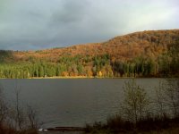
The Sf. Ana lake is a creater lake, and it is the only one in existence in Romania. Some even claim that it is the only one in Europe that keeps it's original crater lake aspect and characteristics.
Located at an altitude above 900m, it has an almost round shape, being closer to a painter's palette in shape.
|
The lake probably appeared after the most recent volcanic blast in the Carpathian mountains, some 42.000 years ago. However, this has not been properly determined, and various specialists have dated the birth of the lake about 32.000, 10.500 or 9.800 years ago.
There are no streams filling the lake, the only source of water being the nearby springs, giving the water an outstanding purity, very close to industrial demineralized water, holding about 0,0029 ml minerals. There's no oxygen in the water, thus no living creatures can call the lake 'home'. During winter time, the lake may get covered in ice, up to 1m thick.
|
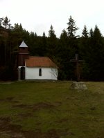
Several legends also exists about the name of the lake. Also to be visited is a small chapel very close to the lake, in a small clearing.
An interesting feature of the surroundings is a natural barometer; it's not a real barometer, but it can accurately predict the weather. There are cracks on the nearby mountain slope; if the air coming out of them "tickles the nose" the storm is approaching, otherwise there will be a great day for hiking around.
|
|
 |
Many thanks to alnegret & LaMarmotte for thier help.
04/16/2012 - Adopted from sharkx. Thank You.
