Tangier Island, like most of the off-shore islands in the Chesapeake Bay, is eroding and subsiding. There used to be a lot more islands in the Chesapeake Bay, and the ones that remain were once much larger than they are today. The University of Maryland’s Laboratory for Coastal Research found that at least 13 islands in Chesapeake Bay have disappeared entirely since the region was first described and mapped by Europeans. Tangier Island is very flat and low-lying, forcing its residents to live mostly on three sandy ridges that rise 1 or 2 yards above mean sea-level.
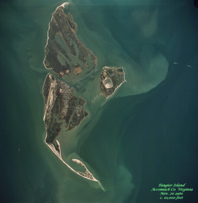
Aerial view of Tangier Island in 1980. |

Comparison of Tangier Island: 1850, 2000,
and projected to year 2100. |
Erosion on Tangier Island
Erosion (i-roh-zhuhn) is a process that moves solids (like rock, soil, and sand) from one place and deposits them in another. On Tangier Island, erosion is driven primarily by wave and wind action off the Chesapeake Bay. These forces are eating away at the island material and depositing it as sediment in other areas of the bay.
Subsidence on Tangier Island
Subsidence (suhb-sahyd-ns) is the motion of a surface relative to a datum (a reference from which measurements are taken). In this case the "surface" is Tangier Island, and the datum is sea-level.
The relative sea-level level of the Chesapeake Bay has been rising steadily for decades and tidal gauges show it has risen more than a foot since 1890. Also, the land itself is actually lowering at a rate of about half a foot per century.
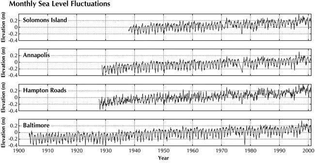
Sea-level trends in the Chesapeake Bay.
To log this cache:
1) Email me with:
a) 300 feet Northeast (50 degree bearing) of the EarthCache location is an interpretive sign. According to the information listed, how much shoreline has been lost on the western side of the island in the last century, and about how much shoreline does the island lose each year?
b) The GPS coordinates and a written description of at least one man-made thing (or its remnants) you saw on the island that was clearly built when the location was at a much higher level relative to the Chesapeake Bay (and would not likely be put in that same location today). Please DO NOT put a picture or description of the location in your log. Including a picture in your email to me as evidence is strongly encouraged.
c) What do you think contributes more to the loss of land area of the island, erosion or subsidence, and why?
2) Attach a photo to your log for this cache, at the cache location, showing three features in contention: The Bay, the Beach, and the man-made Sea Wall, along with your GPSr, and optionally you. I want to see your smiling face on the island if you can possibly manage it.
Logs containing spoiler pictures will be deleted without warning.
You may post your log at any time, but emailed answers must follow within 7 days or your log will be deleted.
Getting there:
Plan ahead! This can be done as a day trip, but must be planned in advance, especially in the off-season. Transport to the island is by boat or aircraft only. There is passenger ferry service available for a fee. For more information, please visit this link.
Image and research contributions by: Philip Goldborough, and the Journal of Coastal Research 21(2):e36-e51. 2005 doi: 10.2112/03-0045.1. Special thanks to the Kaye's and the Tangier History Museum.