
Out of the hills of
Habersham,
Down the valleys of Hall,
I hurry amain to reach the plain,
Run the rapid and leap the fall,
Split at the rock and together again,
Accept my bed, or narrow or wide,
And flee from folly on every side
With a lover's pain to attain the plain
Far from the hills of Habersham,
Far from the valleys of Hall.
from the poem
The Song of the Chattahoochee by Sidney Lanier
(read the whole poem here)
There are
many beautiful rivers in the state of Georgia, and perhaps those of
us living in and around Atlanta don't tend to think of the
Chattahoochee as being one of them, but if you move about the
state, you will find that it truly is a stunning body of water. The
river begins in the Appalachian Mountains of North Georgia at
Chattahoochee Spring, and flows in a Southerly direction for the
total length of the state, until it joins with the Flint River very
near the FL/GA line where the river becomes the Apalachicola River
and continues on to the Gulf of Mexico. It's name is believed to be
of Creek Indian origin and means "painted rock." Surely as you
follow the shores of this great river, there are many beautiful and
multi-colored rock outcroppings that it displays.
here is a
chart showing the ACF (Apalachicola, Chattahoochee, Flint)
watershed

While there
are many amazing aspects to a river system like this one, the
recent flooding in our area has caused me to consider the subject
of flooding and erosion, so that is the focus of this Earthcache.
We are all keenly aware of the dangers that exist in the rivers
flood plain, and our minds are recently reminded of the terrible
damage and even devastation that occurs when it breaches its banks.
Most of us sat in amazement as we viewed the floodwaters on our
televisions. What about the lasting effects of these floods? Not
only are houses, cars, and other possessions damaged, but whole
landscapes can be changed by the commanding power of the river.
Many of these changes will be permanent!
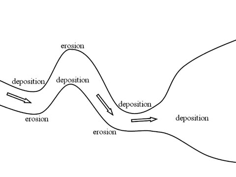
Here is a
very simplistic charted explanation of the most common types of
water erosion.

Under ideal conditions, the above chart shows
just how the water should flow in the river. The fastest water is
in the middle of the river, and therefore it is the deepest part of
the river. The faster moving water erodes and moves the most soil
and even rock.

When there is a bend in the river, there is
greater probability of land erosion. Notice the faster water
channels to the outside of the bend. Now the deepest part of the
river would be where that faster flowing water is, and under normal
circumstances, the river stabilizes itself to these conditions; but
what happens when the river rises significantly from a heavy rain?
The faster flowing water makes contact with the outer bank of the
river, and erosion is multiplied significantly.
If you think about it, the old saying is "what
goes up, must come down," and the same principle is true with
erosion. When the water is higher, or faster than what the river
has become stable to, there is erosion. In other words, the water
loosens and carries away the soil and rock; but eventually the
water slows back down, and the materials are deposited somewhere.
The deposited materials can be considered damage, as much as the
eroded areas of land upstream. The above chart is exactly what has
taken place during our recent flooding. Just a short distance
downstream from Franklin, GA is West Point Lake. It is common for
the lakes in our area to have lower water levels during the Winter,
but right now, there are also large deposits of sand near the main
channel of the lake, which makes boating very risky.
It is interesting to consider the normal levels
of the river, and compare them with the higher levels that are seen
during times of flooding. Here is a very nice website where you can
check the water level in Franklin. It records a reading every
fifteen minutes. The first part of your assignment is to note the
rivers level (in your log) at the time you visit this earth cache.
You will also want to notice the record levels that they have
posted there. It is very interesting to imagine where the water
would be during the flood, and what would it be covering!
http://weather.hamweather.com/rivers/gauge/FRNG1.html

Next, you will need to study the above picture.
This picture was taken before the 2009 flooding, and there is a
very noticeable difference that you will find very near the posted
coordinates.
When you arrive at the posted coordinates, you
will be standing in or around a man-made structure. Estimate the
height of that structure. While it wouldn't seem to be related to
our Earthcache, it is very interesting to note that: in 2005, I saw
the water level of the river up to the roofline on this structure.
I saw this with my own eyes! This flood was recorded on the above
mentioned website. During the recent flooding, which I assumed to
be much worse than the 2005 flood, there were two different friends
who told me that the water level was completely over the top of
this structure. I never made it down there to see for myself, and
on the above mentioned website, there is no mention of 2009 levels.
It may be that this website just hasn't been updated to reflect
those levels, but I cannot be sure. As I stated earlier, it is very
interesting, to imagine where the water would be and how far it
would go, and what all it would cover up, if the water was up there
on that structure!
To get credit for this Earthcache:
1.
Post a picture of yourself, preferably with the river in the
background.
(try not
to show the structure, or the difference in the landscape)
2. Mention in your log, the river level during
your visit.
3. E-mail me a description of the change that
has taken place in the landscape near the coordinates.
4. E-mail me your estimate of the height of
the structure
5. E-mail me your answer to the following
question:
This area has been damaged more by EROSION? or
REDEPOSITION?
(PLEASE DON'T POST SPOILERS IN YOUR
LOG!)
