
Der Bodensee
Die Entstehung des Bodensees hängt eng mit den Alpen zusammen. Geprägt durch die geologischen Strukturen der Alpenauffaltung formten die Alpengletscher das Bodenseegebiet während des Eiszeitalters (Pleistozän) in mehreren Vorstößen. Als sich vor etwa 16.000 Jahren der Rheingletscher nach der letzten Eiszeit (Würm) zurückzog, hinterließ er ein Gletscher-Zungenbecken, das sich mit Wasser füllte und den Bodensee in seiner heutigen Form entstehen ließ. Damals war er allerdings noch fast doppelt so groß wie heute. Erst durch die Sedimente des Rheins wurde das Becken nach und nach aufgefüllt, so dass der See heute nur noch eine Fläche von ca. 536 km² hat und seine Größe weiter abnimmt.
Die Erdkrümmung
Wegen der Erdkrümmung (mittlerer Erdradius 6371 km) verfügt der Bodensee in seiner Südost-Nordwest-Ausdehnung über eine Aufwölbung der Oberfläche von rund 80 m. Aus menschlicher Perspektive ist es daher in Ufernähe auch bei bester Fernsicht nicht möglich, vom Ostufer von Bregenz (427 m ü. A.) aus, zum Westufer nach Konstanz (405 m ü. NN) zu blicken. 
Dazu befindet sich unter dem Bodensee eine stärkere Abweichung zur Tangentialebene, was den Krümmungseffekt verstärkt.
Bis zum Horizont und weiter?
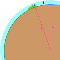 Der Horizont ist die Grenzlinie zwischen der sichtbaren Erde und dem Himmel. Durch die Krümmung der Erde wird die maximale Sichtweite für Objekte auf der Erde begrenzt. Die Sichtweite von einem erhöhten Beobachtungspunkt oder die Sichtbarkeit eines hohen Objekts (z. B. Berggipfel) aus einer Ebene oder Meereshöhe lässt sich nach dem Satz des Pythagoras berechnen, da Sichtverbindung und Erdradius die Katheten eines rechtwinkligen Dreiecks bilden und der Abstand des erhöhten Punktes vom Erdmittelpunkt dessen Hypotenuse.
Vereinfachte Formel zur Berechnung der geometrischen Sichtweite(s) in km unter Einbezug des Erdradius und der Augenhöhe(h) in Meter:
3,57*√h
Detailiertere Erklärung zur Berechnung der geometrischen Sichtweite lassen sich bei Wikipedia finden, zum Loggen des Earthcaches nicht notwendig.
Der Standpunkt

Der Bodensee befindet sich auf 395m Höhe über dem Meeresspiegel, der angrenzende Hausberg Pfänder auf 1064m. Steht ihr auf dem höchsten Punkt des Berges haben eure Augen also etwa 695,5 Meter über der Wasseroberfläche des Sees. Ihr könnt dann also etwa 97 km weit sehen. Das reicht theoretisch aus um weit über den See hinaus zu blicken, denn der See ist etwa 63 km lang.
Nun steht ihr aber unten am Ufer und wir gehen jetzt einfach davon aus, daß ihr alle Objekte von hier bis zur Wasseroberfläche sehen könnt, und nicht nur die Kirchturmspitzen...
Benutzt der einfachheithalber die nachfolgende Tabelle zum Ablesen und nehmt eure Augenhöhe in Meter und addiert die ungefähre Höhe der Uferpromenade von der Wasseroberfäche dazu.
Augenhöhe in Meter + Höhe der Uferpromenade ergibt Sichtweite in km
Tabelle/table:
1 m: 3,6 km  --  9 m:10,7 km
2 m: 5,0 km  --  10m:11,0 km
3 m: 6,1 km  --  15m:13,8 km
4 m: 7,1 km  --  20m:16,0 km
5 m: 8,0 km  --  50m:25,0 km
6 m: 8,7 km  -- 100m:35,0 km
7 m: 9,4 km  -- 200m:50,0 km
8 m:10,0 km  --
Aufgaben*
1. Suche nicht mehr nach dem stählernen Bilderrahmen wo man bis 2016 noch "Signale um den Bodensee" senden konnte, sondern das Binokular an der Promenade, in der Nähe der oben angegebenen Koordinaten N 47° 30.334 E 009° 44.740.
2. Schätze den momentanen Wasserstand oder aber für ganz genaue Messungen findet man auch in der Nähe einen Wasserstandsanzeiger.
3. Sende nachfolgende Ergebnisse deiner Messungen ans Message-Center oder über unser Profil.
a) Peile von hier aus nach Konstanz (N47° 39.647 E009° 10.847) oder Referenzpunkt dem Wegpunkt zu entnehmen. Wieviele km auf 2 Nachkommastellen auf- oder abgerundet, ist es entfernt?
b) Wieviel km weit könnt ihr theoretisch bei aktuellem Wasserstand blicken? Ein Anhaltspunkt wie zu messen ist findet ihr in der Tabelle unter Standpunkt, oder für genaue Messungen die Formel unter Horizontberechnung!
c) Sucht euch dann auf eurem GPSr einen Ort/Objekt am See aus, den ihr bei euren momentanen Sichtverhältnissen gerade noch sehen könnt.
Freiwillige Aufgabe:  Mach' ein Foto Richtung Konstanz und lade es bei deinem Log hoch. Es bleibt dir überlassen, ob du mit drauf bist, dein GPSr oder dein Maskottchen!
Viel Spaß wünschen
[numakeh]!
*) zur Überprüfung deines durch den Earthcache erlangten Wissens, setzt unbedingt deine Anwesenheit vor Ort voraus, das Beantworten der Fragen und das Senden einer Email über unser Profil oder über das Message-Center. Das Abwarten einer Antwortmail ist nicht nötig.

Description in English:
The Lake of Constance
Lake Constance was formed by the Rhine Glacier during the Ice Age (Pleistocene). The Rhine, the Bregenzer Ache, and the Dornbirner Ache carry sediments from the Alps to the lake, thus gradually decreasing the depth of the lake in the southeast. About 16,000 years ago, when the Rhine Glacier retreated after the last ice age (Würm), he left a Glacier Tongue Basin that filled with water, and Lake Constance was formed in its present form. At that time, however, he was still almost twice as large as today. Only through the sediments of the Rhine basin was filled up gradually, so that the lake is now only in area of about 536 km² and its size continues to decline.
The curvature of the Earth
Due to the curvature (Earth Radius 6371 km) of the Lake Constance has in its south-north-west extension of the bulge on a surface of about 80 m. From a human perspective, it is not possible even with the best views from the east bank of Bregenz (427 m above sea level Austria) to the west bank to look at Constance (405 m above sea level, NN).
This is located at Lake Constance greater deviation from the tangential plane, which increases the curvature effect.
To the horizon and then?
The horizon is the apparent line that separates earth from sky. Due to the curvature of the earth, the maximum visibility is limited to objects on the Earth. The sight of an elevated observation point or the visibility of a high object (pe. mountain peaks) from a plane or altitude can be calculated by the theorem of Pythagoras, as sight and the Earth, the hypotenuse of a right triangle is formed and the distance of the point raised by the center of the earth whose hypotenuse.
Simplified formula for calculating the geometric Visibility (s) in km below the Earth's radius, and the inclusion of eye height (h) in meters:
More detailed explanation for calculating the geometric Visibility can be found here, it isn't necessary for logging this Earthcache.
The Point of View
The Lake of Constance is located at 395m above sea level, the Pfänder at 1064m. On the top of the mountain, your eye-level is about 695.5 meters above the lake's surface. You can nearly see about 97 km. This goes far beyond the lake because the lake measures about 63 km long.
We're going simply assume that you'll be able to see objects up to the surface, not just the steeples ... Therefore you can use the table above to read: Take your eye level and add the height of the boardwalk to the water surface.
Tasks*
1. Do not search steel frame where you could sent "Signale um den Bodensee" until 2016, but the Binocular nearby the above-mentioned coordinates N 47 ° 30,334 E 009 ° 44,740.
2. Estimate the water level or look at the water level indicator nearby.
3. Send your measurements on subsequent results to our profile or about the Message Center.
a) Make a bearing from here to Constance (N47 ° 39,647 E009 ° 10,847), or take the reference point from the waypoint. How many km to 2 decimal places rounded up or down, is it far away?
b) How many km can you look around at the current water level? Take the table of the point of view, or the formula from the horizon.
c) Search with your GPSr a place/object on the lakeside, which you can see just barely in your current visibility.
If you like you can take a picture in the direction of Constance and load it up with your log. It is up to you whether you are on it, your GPSr or your mascot.
Have fun
[numakeh]
*) To check your knowledge gained through this earthcache, it absolutely requires your presence on the ground, you have to answer the questions and send an email to us. You don't have to wait for the reply mail.
Edit im März 2016: Nach dem Verschwinden des Bilderrahmens haben wir eine kleine Änderung im Listing vorgenommen, siehe Log.