Park at the main parking lot for the Park. ($4.00 fee during
summer season) and follow the paved trail beside the highway to the
road crossing waypoint (N 43° 02.756’, W 070°
43.169’) across from a historic farmhouse now used for the
Seacoast Regional Office of the NH Division of Parks. (be careful
of traffic when you cross the road, it can be busy at times)
Between the house and the barn is a trail which goes along the salt
marsh and will let you gather information to claim this find. Make
sure to spend some time at the old cemetery along your walk; it is
one of the oldest in New Hampshire.
For more information about Odiorne Point State State Park go to
link
INTRODUCTION
What is a Salt Marsh?
Salt marshes are grass-dominated tidal wetlands between land and
salty or brackish water. Salt marshes serve as the transition from
the ocean to the land, where fresh and salt water mix. Salt marsh
plants are salt tolerant and adapted to water levels that fluctuate
with the tide. Tides carry in nutrients that tend to settle in
roots of the plants within the salt marsh stimulating plant growth
in the marsh They also carry out organic material that feeds fish
and other organisms. The natural chemical activity of salty (or
brackish) water and the tendency of algae to bloom in the shallow
unshaded water also allow for great biodiversity. Salt marshes are
among the most productive ecosystems on earth, rivaling that of an
Iowa cornfield. The position of salt marshes on the landscape and
their productivity makes them important not only as a part of the
natural world but also to humans. In the 1600’s when the
European settlers arrived on these shores, the salt marsh was
critical to their survival. Here was a ready supply of hay for
their animals which gave the settlers time to build dwellings and
to clear forests for the planting of crops. Until the early part of
the 1900’s, the harvesting of salt marsh hay was an important
annual event with most members of the families being involved.
Salt Marsh Formation
This salt marsh is probably not much more than 4,000 years old. The
last ice age covered this land with ice about a mile thick. As this
huge glacier moved toward the sea, the eroded material from the
former mountains was scraped away down to bedrock. The weight of
the ice depressed this land as much as 1,200 feet. As the earth
warmed and the glacier waned, the melting waters deposited sand and
gravel which can be found underneath the marsh. It was about 4,000
years ago that the sea level became relatively stable. The barrier
island, which is now Odiorne Point State Park, allowed sediments to
be captured and piled up behind it. When these sediments were high
enough to be exposed between the tides, seeds brought in perhaps on
the feet of migrating birds, took root and the salt marshes began
to form. Over many years the sediments and dead plants accumulated
and became compressed to form the peat marsh. As the sea level
slowly rose, flooding waters added more sediments so the marsh peat
continued to build. The sea level and the marsh grew at the same
ratem about 8 inches per 100 years. Peat in this marsh has been
measured to a depth of ten feet.
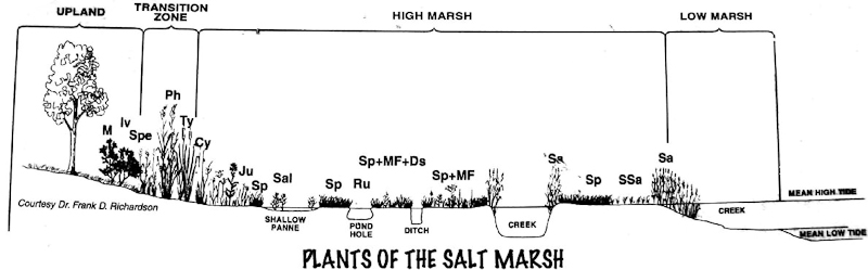
SALT MARSH
ZONES
Salt marshes can be extremely difficult places to live because
of wide daily fluctuations in salinity, water, temperature, and
oxygen. Few plants have evolved adaptations to cope with the
extreme conditions of salt marshes. Plant zonation in a salt marsh
results from species-specific adaptations to physical and chemical
conditions. Looking out on a healthy salt marsh in full summer
growth, one can observe distinct zones of plant growth. Bands of
tall grasses inhabit the saturated banks of creeks and bays, and
this zone is bordered by a flat "meadow" of grasses and sedges that
may extend landward for a great distance before transitioning into
upland habitats where there is a greater diversity of shrubs,
flowering plants, and grasses. The different zones are described
below.
The Low Marsh
The low marsh is located along the seaward edge of the salt marsh.
It is usually flooded at every tide and exposed during low tide. It
tends to occur as a narrow band along creeks and ditches, whereas
the high marsh is more expansive and is flooded less frequently.
The predominant plant species found in the low marsh is the tall
form of smooth cordgrass (Spartina alterniflora). This species can
reach a height of six feet and is very tolerant of daily flooding
and exposure.
The High Marsh
The high marsh lies between the low marsh and the marsh’s
upland border. It can be very expansive in some areas, sometimes
extending hundreds of yards inland from the low marsh area. Soils
in the high marsh are mostly saturated, and the high marsh is
generally flooded only during higher than average high tides. Plant
diversity is low (usually less than 25 species), with the dominant
species being the grasses and rushes such as salt hay grass, spike
grass, black grass, and the short form of Spartina alterniflora.
Other plant species commonly found in the high marsh are perennial
salt marsh aster, and sea lavender.
Pannes and Pools
Pannes are shallow depressions located within in the high marsh.
They hold standing water and typically dry out during extended dry
periods, such as at the end of the summer season. Salinity can
reach extremely high concentrations in pannes and only the most
salt-tolerant species can exist at panne edges including common
glasswort, seaside plantain, and the short form of Spartina
alterniflora, as well as some blue-green algae. There are some
larger, deeper, and more permanent depressions (called pools) in
the high marsh that can be vegetated with submerged aquatic species
such as widgeon grass and are inhabited by salt marsh fish. Both
pools and pannes (when not entirely dried out to cracked, dry mud)
are very valuable habitat for migratory water birds.
Upland Border
The marsh border is located at the salt marsh’s upland edge
and other isolated areas on the marsh where elevations are slightly
above the high marsh. The marsh border is usually only flooded at
extreme astronomical tides and under irregular conditions such as
storm surges or wind-driven tidal inundations, and does not
experience waterlogged conditions or severe salt stress. A high
diversity of herbs, shrubs, and even trees exists in the marsh
border. Marsh elder, sweet gale, seaside goldenrod, and switchgrass
are just some of the many marsh border plants.
The image below graphically shows the zones
described above. All plant names can be found on signs at the
cache.
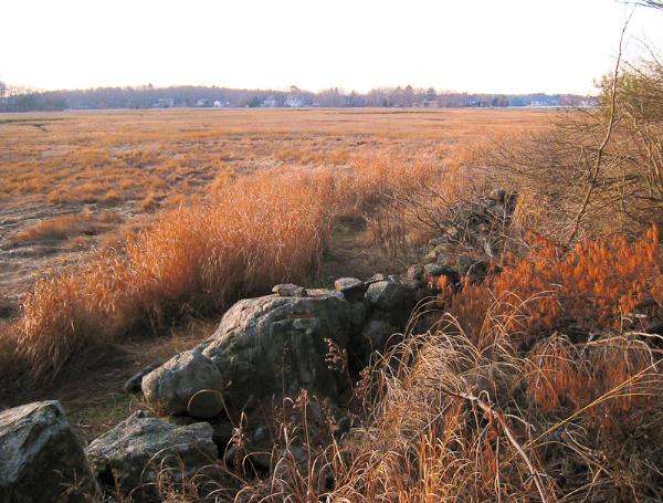
 Look out at the salt marsh and you can easily see the extent of the
high marsh as well as some small shrubby upland areas within the
high marsh.
Look out at the salt marsh and you can easily see the extent of the
high marsh as well as some small shrubby upland areas within the
high marsh.
FUNCTIONS AND
VALUES OF THE SALT MARSH
Nursery Area for Fish, Crustacea, and Insects
We know that the productivity of a corn field goes to feed humans
and livestock, so who benefits from salt marshes? Research
increasingly points to aquatic wildlife as the main recipient of
marsh production. Little vegetation is consumed directly, but is
broken down by bacteria and small insects. The decaying plants and
microbes are eaten by larger crustaceans, insects, fish, and
mussels that reside in the marsh soils, ditches, and pools where
they are protected from predators. That is, until the tide comes in
and predators are able to locate and eat the smaller critters.
Thus, the salt marsh provides the food for larger fish that are
important to the New England fishing industry. Over the past
decade, fishery stocks in New England have seriously declined.
There is evidence that restoring marshes, along with improved
fishing management, will help to restore these fish stocks.
Protection Against Waves and Sea Level Rise
Over the past 6,000 years, the ocean has risen many feet in
elevation. It is not uncommon to dig in a salt marsh and find the
stumps of cedar trees preserved underneath. Because saltmarshes
trap nutrients and sediment, and build organic matter to form peat,
they are able to grow and keep pace with the rising ocean. Current
forecasts call for the sea level to rise at least another foot in
the next 100 years. The salt marshes will keep pace with this rise
if we let them. The marshes also slow the velocity of waves before
they reach land and mitigate storm surges. In places where marshes
have been destroyed, winter storms are more damaging.
Mosquito Control
Historically, people have drained marshes, by creating ditches, to
both harvest salt marsh "hay" for cattle, and to control
mosquitoes. In many areas, the practice of ditching for mosquito
control is ineffective and counterproductive. When marshes are
drained, mosquito habitat remains in the panes and pockets of water
but their main predator, the mummichog, loses its habitat. Over
time, the ditches fill back in causing more stagnant water. The
introduction of tide gates does not eliminate mosquitoes either
because it results in freshwater ponding, which simply causes
freshwater mosquitoes to replace the saltwater species. Restoring
marshes can dramatically increase fish populations that control the
mosquitoes.
Sources: adapted from NHDES Environmental Fact Sheets,
local information signs and from wikipedia
LOGGING
REQUIREMENTS
The cache coordinates will bring you to two different
observation platforms overlooking this salt marsh. The answers to
the following questions can be found at one or the other of these
platforms.Email me the answers to the following questions:
Question #1: While at the first platform, describe by its name,
the man made structure which is built about 60 ft. out into the
marsh, and give its purpose.
Question #2: At one of the platforms, you will find an
information sign which describes the 4 P’s of salt marsh.
What are the tons of biomass productivity per acre per year for
agriculture and for estuaries writen on this sign? Your answer must
be exactly as printed on the sign.
Question #3: What are the two Crustaceans that are found in this
salt marsh? (use common names) Various salt marshes may have
different crustaceans, so do not count on finding the correct
answer on-line.
Also, if you wish, attach a photograph of you and your GPSr with
the marsh in the background
After visiting this salt marsh, go across the street and
enjoy the remainder of the Park. There are two other earthcaches in
the park. (The Dikes of Odiorne Point GC15NZV & Sunken Forest
GC15NZJ) as well as numerous traditional caches.