The Nistru/Dniester River
 The Nistru
(=Moldovan/Romanian name, Dniester =Russian/English) rises in
Ukraine, near the city of Drohobych, close to the border with
Poland, and flows toward the Black Sea over a total length of 1,362
km. Its course marks part of the border of Ukraine and Moldova,
after which it flows through Moldova for 398 km, separating the
bulk of Moldova's territory from Transnistria. It later forms an
additional part of the Moldova-Ukraine border, then flows through
Ukraine to the Black Sea, where its estuary forms the Dniester
Liman.
The Nistru
(=Moldovan/Romanian name, Dniester =Russian/English) rises in
Ukraine, near the city of Drohobych, close to the border with
Poland, and flows toward the Black Sea over a total length of 1,362
km. Its course marks part of the border of Ukraine and Moldova,
after which it flows through Moldova for 398 km, separating the
bulk of Moldova's territory from Transnistria. It later forms an
additional part of the Moldova-Ukraine border, then flows through
Ukraine to the Black Sea, where its estuary forms the Dniester
Liman.
Soroca
The city has its origin in the medieval Genoese trade post of
Olchionia, or Alchona. It is known for its well-preserved fortress
(Cetatea Soroca, see waypoint FORT / "Fortress"), established by
the Moldavian Prince Stephen the Great and Holy (Ştefan cel
Mare şi Sfânt in Romanian) in 1499. During the Great Turkish
War, the fortress was successfully defended against the Ottomans.
The Soroca fortress is an important attraction in Soroca, having
preserved cultures and kept the old Soroca in the present
day.
The locality was greatly extended in the 19th century, during a
period of relative prosperity. Soroca became a regional center
featuring large squares, modernized streets, hospitals, grammar
schools and conventionalized churches. In the Soviet period the
town became an important industrial center for northern
Moldova.
Meanders and Limestone Cliffs
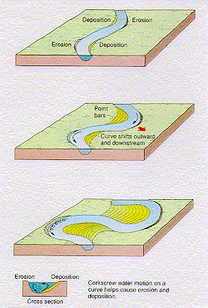 In this area, the Nistru
has formed a very wide, meandering valley with high limestone
cliffs on the outer sides. A meander is formed when the moving
water in a river erodes the outer banks and widens its valley. That
way, the bend becomes wider over time. A stream of any volume may
take a meandering course, alternatively eroding sediments from the
outside of a bend because the water "pushes" against the outer
bank, and depositing them on the inside because the water moves
slower there. The result is a snaking pattern as the stream
meanders back and forth across its down-valley axis. When a meander
gets cut off from the main stream, an oxbow lake is formed.
In this area, the Nistru
has formed a very wide, meandering valley with high limestone
cliffs on the outer sides. A meander is formed when the moving
water in a river erodes the outer banks and widens its valley. That
way, the bend becomes wider over time. A stream of any volume may
take a meandering course, alternatively eroding sediments from the
outside of a bend because the water "pushes" against the outer
bank, and depositing them on the inside because the water moves
slower there. The result is a snaking pattern as the stream
meanders back and forth across its down-valley axis. When a meander
gets cut off from the main stream, an oxbow lake is formed.
The meander bows here are extremely wide, the diameter of the bow
where the EarthCache is located is about 4km and the total width of
the valley, from here to the next bow on the opposite side, is
about 10km. So you will hardly notice that it's a bow (on the
picture it only looks like it because it was taken at a very wide
angle), but you can clearly see the meanders on a map or on the
satellite picture above.
The area is largely founded on limestone, with some sandstone and
clay deposits. The Nistru has carved itself deep into the
foundation, forming steep cliffs up to 120m high on the outer banks
of its meanders. At this point, a small side river is joining the
Nistru, which has also cut a steep valley into the limestone, the
Bechir (Bekyr) Canyon.
An interesting side note on meanders: According to Baer's Law, the
erosion is stronger on the right bank of a river on the northern
hemisphere. Einstein managed to explain this effect through the
Coriolis force. So as we're here on the right bank of the Nistru,
it means the erosion on this side is stronger than on the left
bank... although because the Coriolis force is only very small, the
effect is minimal and probably not measurable.
The Cache
If you arrive by car, you can park directly at the listed
coordinates, there's enough space for a few cars. It's also easy to
get to Soroca by bus or minibus (Marshrutka), there are frequent
connections from Chişinău (Gara de Nord), as well as
connections from other cities in Moldova and Ukraine. The location
can be reached by foot (about 1.2km) from Soroca's bus terminal
(waypoint BUS / "Bus Station").
From the start coords, this EarthCache takes you to three different
stages in different directions, which you may do in any order.
However you must come back to the start coords after each
location, particularly do not attempt to go directly from the
monument to the cave or you risk falling off a high cliff! The
questions should all be easy to answer and completing all the three
stages probably takes about an hour, count extra time if you want
to visit the cave or see more of the area.
Stage I: Stairs, Rock, Candle, View
Read the altitude from the GPS at your start location, you will
need it at the top of the hill (for most Garmin units, simply mark
a waypoint and it will contain the altitude above Sea level).
From the start coords, pass through the stone gate and start
climbing the stairs - take it easy, it's 564 steps up to the
monument. There are benches where you can take a rest on the way if
needed ;) Just before you get to the top, you will see a large rock
face situated on the right of the stairs (WP1 "Rock"). Take a
closer look at the rock surface and answer these three
questions:
- Question Q1: Which one of the following three images
shows the surface of the rock?

a) Fossil limestone
b) Calcareous sinter / Travertine
c) Cellular limestone / Rauhwacke
- Question Q2: Give a short (1-2 phrases) explanation of
how this type of surface structure (from Q1) is formed (search
internet, or better try to write down your own deduction).
- Question Q3: Estimate the height of the rock face.
Now continue to the top to WP2 ("Candle/View") and enjoy the
view from near the monument. You are on top of the outer bank of a
large meander formed by the Nistru, the flat inner bank on the
other side is already part of Ukraine.
The monument, which is some 30m tall, symbolizes a candle and is
called "Lumînarea Recunoştinţei" ("Candle of
gratitude/recognition"). It represents a tribute to the anonymous
heroes who have preserved the culture, language and history of
Moldova. If the monument guard is around, you may be allowed to
enter it (there's a religious shrine inside).
Your tasks:
- Picture P1: Take a picture showing you and at least part
of the monument or the Nistru in the background.
- Question Q4: Calculate the approximate height of the
cliff at this location from your GPS altitude reading (subtract the
start location altitude from the current altitude)
Stage II: Bechir's Cave
Go back down the stairs to the start coords (this is
important: do not try to go to the cave
directly from the monument or you risk falling of a >20m
cliff!), and take the path into the valley towards WP3
("Cave"). After a short bit, you get to a large rock with a fish
carved on its surface. Either go directly up to the right towards
the limestone cliff face, or if it's too slippery, follow the path
for another 40m, from where it should be a bit easier.
Once you get to the foot of the vertical limestone cliff, you will
see some steps in the wall, leading to the entrance of a small
cave. In this cave, called "Peştera lui Bechir" (Bechir's or
Bekyr's cave), a monk is said to have lived during the 19th century
without anybody knowing of him. The steps leading to the cave were
carved later, the monk himself apparently used to climb down to the
cave from above on a rope. The cave is very small, but built to
allow somebody to live in it. There's a stone bench that was
probably used to sleep, a fire place next to the window for smoke
exit, and a small altar room in the back - all carved into the
stone.
You may climb up into the cave at your own risk if you like,
however be extremely careful if you decide to
do so, and don't attempt it if you are there on your
own, or if it's wet! The limestone is very soft and slippery and
pieces can break out, and even more slippery when wet. Only do
it if you're sure about it and if another person is there, just in
case! If you're on your own and something happens, nobody will
happen to pass there and find you, think of that before you go!
That said, if you do climb up, try finding the resonance
frequencies inside the cave by humming in different tones. If you
hit it, the entire cave seems to chant with you, creating a very
special sound!
Your tasks (climbing up to the cave not required!):
- Picture P2: Take a picture showing you at the base of
the steps leading up to the cave, or inside the cave.
- Question Q5: Estimate the altitude from the base to the
cave.
Stage III: The Fountain
After all this hard work going up and down stairs and possibly
climbing up into the cave, you deserve a fine cold drink! Go back
to the start coords, cross the road and take the small road going
south east along the Nistru (which is hidden behind trees) towards
WP4 ("Source"). After about 300m, a few steps down to the left lead
you to the fountain. Subterranean rivers are very common in
limestone and karst formations, leading to many water sources. The
water here is of good quality and locals come here to fill large
bottles for their home use. Drink if you like, and answer the
following questions:
- Question Q6: In which century was the source
founded?
- Question Q7: In which year was the source
renovated?
That's it. Please email me your answers to the questions
through my profile (don't write the answers in your log!),
attach the two required pictures to your log (you're welcome
to add more if you wish). Feel free to log before you get my
confirmation, I'll contact you in case there's a problem with your
answers (it may take me a while to get back if I'm
travelling...).


Wikipedia source articles used: Nistru,
Soroca, Meander, Limestone
Other sources:
Picture sources: Own pictures, +some from
Wikipedia

The most exciting way to learn about the Earth
and its processes is to get into the outdoors and experience it
first-hand. Visiting an EarthCache site is a great outdoor activity
the whole family can enjoy. An EarthCache site is a special place
that people can visit to learn about a unique geoscience feature or
aspect of our Earth. Visitors to EarthCache sites can see how our
planet has been shaped by geological processes, how we manage the
resources and how scientists gather evidence to learn about the
Earth. Learn more about EarthCaches.