The Sandhills.
The Sandhills is a region in the interior of the U.S. states of North Carolina and South Carolina. It is a strip of ancient beach dunes which generally divides the Piedmont from the Coastal Plain, and is the evidence of a former coastline when the ocean level was higher, or the land lower. The beach deposits were formed principally during the Miocene Epoch, Circa 20 millions years ago before the present. Typically, beach fossils are found along the front edges. An example being a quarry at Old Dock, NC east of Whiteville, NC along NC 130. The coastal plain is terraced from other ocean levels, but none appear to have been so long-lasting, so as to build up dunes this size.
The Sandhills are an important ground water recharge area for the coastal aquifers in the Carolinas. It takes several hundred years for water to move underground from the Sandhills to the South Carolina coast. With this in mind, it is equally true that this water has taken several hundred years to make its way from the edge of the Blue Ridge Mountains to the Sandhills area of North Carolina.

Coastal Plain.
The Coastal Plain is a wedge of mostly marine sedimentary rocks that gradually thickens to the east. The Coastal Plain is the largest belt in the State covering 45 percent of the land area. The most common sediment types are sand and clay, although a significant amount of limestone occurs in the southern part of the Coastal Plain. In the Coastal Plain, geology is best understood from studying data gathered from well drilling. The State's most important mineral resource in terms of dollar value is phosphate, an important fertilizer component, mined near Aurora, Beaufort County. Industrial sand for making container and flat glass and ferrosilicon and used for filtration and sandblasting is mined in the Sandhills area. When one combines the rolling hills of the Sandhills region of North Carolina with the interfolding of ridges and valleys, the conditions are right for the formation of springs. The layers of aquifers find a weak area in the terrain or just run out of its land mass as a cover. The outlet for the spring opens allowing the pressure of the layers over the aquifer to expel its media.
What is a Spring ?
“A spring is a water resource formed when the side of a hill, a valley bottom or other excavation intersects a flowing body of ground water at or below the local water table, below which the subsurface material is saturated with water. A spring is the result of an aquifer being filled to the point that the water overflows onto the land surface. They range in size from intermittent seeps, which flow only after much rain, to huge pools flowing hundreds of millions of gallons daily.
The forcing of the spring to the surface can be the result of a confined aquifer in which the recharge area of the spring water table rests at a higher elevation than that of the outlet. Spring water forced to the surface by elevated sources are artesian wells. This is possible even if the outlet is in the form of a 300-foot deep cave. In this case the cave is used like a hose by the higher elevated recharge area of groundwater to exit through the lower elevation opening.
Non-artesian springs may simply flow from a higher elevation through the earth to a lower elevation and exit in the form of a spring, using the ground like a drainage pipe.
Still other springs are the result of pressure from an underground source in the earth, in the form of volcanic activity. The result can be water at elevated temperature as a hot spring.”
How are springs formed?
“Springs may be formed in any sort of rock. Small ones are found in many places. In Missouri, the largest springs are formed in limestone and dolomite in the karst topography of the Ozarks. Both dolomite and limestone fracture relatively easily. When weak carbonic acid (formed by rainwater percolating through organic matter in the soil) enters these fractures it dissolves bedrock. When it reaches a horizontal crack or a layer of non-dissolving rock such as sandstone or shale, it begins to cut sideways, forming an underground stream. As the process continues, the water hollows out more rock, eventually admitting an airspace, at which point the spring stream can be considered a cave. This process may to take tens to hundreds of thousands of years to complete.”
Types of spring outlets.
“1) Seepage or filtration spring. The term seep refers to springs with small flow rates in which the source water has filtered into permeable earth.
2) Fracture springs, discharge from faults, joints, or fissures in the earth, in which springs have followed a natural course of voids or weaknesses in the bedrock.
3) Tubular springs are essentially water dissolved and create underground channels, basically cave systems.”
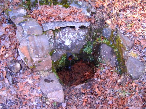
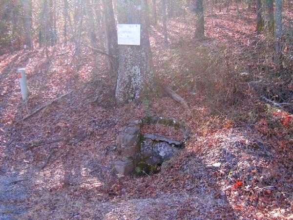
Water flow from Sandhills Old Spring.
“The amount of water that flows from springs depends on many factors, including the size of the caverns within the rocks, the water pressure in the aquifer, the size of the spring basin, and the amount of rainfall. Human activities also can influence the volume of water that discharges from a spring—ground-water withdrawals in an area can reduce the pressure in an aquifer, causing water levels in the aquifer system to drop and ultimately decreasing the flow from the spring.”
![]()
Why is Sandhills Old Spring Drinkable?
“The quality of the water in the local ground-water system will generally determine the quality of spring water. The quality of water discharged by springs can vary greatly because of factors such as the quality of the water that recharges the aquifer and the type of rocks with which the ground water is in contact. The rate of flow and the length of the flow path through the aquifer affects the amount of time the water is in contact with the rock, and thus, the amount of minerals that the water can dissolve. The quality of the water also can be affected by the mixing of freshwater with pockets of ancient seawater in the aquifer or with modern seawater along an ocean coast. Groundwater tends to maintain a relatively long-term average temperature of its aquifer; so flow from a spring may be cooler than a summer day, but remain unfrozen in the winter.”
Mineral Springs.
“Minerals become dissolved in the water as it moves through the underground rocks. This may give the water flavor and even carbon dioxide bubbles, depending on the nature of the geology through which it passes. This is why spring water is often bottled and sold as mineral water, although the term is often the subject of deceptive advertising. Springs that contain significant amounts of minerals are sometimes called 'mineral springs'. Springs that contain large amounts of dissolved sodium salts, mostly sodium carbonate, are called 'soda springs'. Many resorts have developed around mineral springs and are known as spa towns. On a historical note, nearby Jackson Springs, NC was a site in the early 1900’s for the well-to-do to take the healing waters. The mineral springs there were popular for several years for those with many afflictions. As a side note, the water at the present day springs only a few miles away is bitter and odiferous. It is amazing that this spring has such good quality water yet only a couple of miles away the water is undrinkable due to taste and smell. The irony is that the water is actually safe to drink if one can stand the offending factors.”
Classification.
“Springs are often classified by the volume of the water they discharge. The largest springs are called "first-magnitude," defined as springs that discharge water at a rate of at least 2800 liters or 100 cubic feet (2.8 m3) of water per second.”
1st Magnitude = > 100 cubic feet per second (cfs)
2nd Magnitude = 10 to 100 cfs
3rd Magnitude = 1 to 10 cfs
4th Magnitude = 100 gal/min (gallons/minute) to 1 cfs (448 gal/min)
5th Magnitude = 10 to 100 gal/min
6th Magnitude = 1 to 10 gal/min
7th Magnitude = 1 pint to 1 gal/min
8th Magnitude = Less than 1 pint/min
0 Magnitude = no flow (sites of past/historic flow)
Chart information cited from: http://en.wikipedia.org/wiki/Spring_%28hydrosphere%29
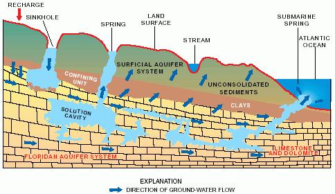
Ground-Water Flow in the Coastal Plain Aquifers of North Carolina
“The characteristics of the Coastal Plain aquifers of North Carolina are being studied as a part of the Regional Aquifer System Analysis program of the United States Geological Survey involving North and South Carolina to assure water resources are protected and used in the best interest of all users along the aquifer.As a twist of fate, this study was actually initiated as part of a study for the new interstate highways, designated I-73 and I-74, another means of conveyance not too much unlike the aquifer flow only faster. With the I-73 portion entering South Carolina just below Rockingham and both highways winding through North Carolina from above Greensboro, NC, they cross from the extreme northern reach of the underlying aquifers to approximately the middle of the underlying aquifers. If this was not a small quirk of happenings, the aquifer identified as supplying this spring is the Middendorf Aquifer, more on this later and the significance of its name.One must remember that with mass transit lanes that the potential for contamination of this and other aquifers exist with any moderate to large spills along the route of the highway. Remember that any damage that occurs to an aquifer not only affects the immediately available area but adjacent aquifers too. Potentiometric maps were constructed for the Middendorf aquifer of Cretaceous age and for the Floridan aquifer system and its sand facies equivalent, Tertiary sand aquifer, prior to development. The Coastal Plain aquifers are recharged primarily by precipitation in their outcrop areas. Ground water flows from these areas of recharge, through the aquifers, and discharges to upper Coastal Plain rivers, overlying aquifers as upward leakage, and wells. Ground-water flow in the Floridan aquifer system and the Tertiary sand aquifer prior to development is generally perpendicular to the coast. Pre-development flow in the Cretaceous aquifers, however, turns northeastward as it approaches the coast, almost paralleling the coast. The change in flow direction is caused by less effective intervening confining units, the aquifers being closer to the land surface, and the rivers at lower altitudes farther upstream in the vicinity of the North Carolina/South Carolina State line.
Water-level declines in the Cretaceous aquifers have occurred throughout much of the eastern part of the Coastal Plain of North and South Carolina due to pumpage in the areas more industrialized and more populated cities and counties. Large area of extensive water-level declines have also occurred in the Floridan aquifer system in South Carolina due to pumpage in the Savannah, Georgia area.”
The Aquifer’s Extent.
(from an article it The Pilot, local newspaper in the Pinehurst area)
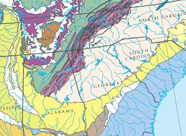
By any measure, the Middendorf Aquifer is huge.
It “runs out” somewhere around N.C. 211. Wells drilled north of that road often come up dry.
But from Pinehurst, the aquifer flows slightly downhill to Aberdeen — which gets water from its own system of wells — and Hoke, Scotland and Robeson counties and to the Fuquay-Varina area. It is still relatively near the surface in those areas.
Even Southern Pines and other Moore County communities that draw their water from Drowning Creek make use of the Middendorf Aquifer, Brobst says. That’s because the aquifer — along with surface water — feeds the creek.
“Surface water is just groundwater with no ground on top of it,” he says. The aquifer continues to go downward throughout much of the Coastal Plain to Cape Hatteras on the Outer Banks, where several other aquifers overlay it. Through part of this area, the aquifer is known as the “Black Creek Aquifer,” after a prominent stream in the section where the aquifer was first described in North Carolina. But it is the same aquifer.
To the southwest, still going downward for the most part, the Middendorf Aquifer underlies much of South Carolina, Georgia and Alabama, where it is known as the Tuscaloosa Aquifer. There is then some discontinuity, but there are “remnants” of the sedimentary formation making up the Middendorf Aquifer as far west as Texas, where it is commonly known as the Woodbine Aquifer.
The Aquifer’s Name.
“There is some disagreement about how the Middendorf Aquifer got its name.
Because Pinehurst sits on a high “outcrop” of the aquifer, Donald Van Roosen has suggested that the aquifer may have been named for a Middendorf family who came to the area in 1892, before the village was founded.
(Van Roosen is chairman of the Water Resources Committee of the Village of Pinehurst Planning and Zoning Board, which has studied the Middendorf Aquifer in some detail.)
Brobst says the aquifer must have been named for the geologist who discovered it. There have been prominent geologists named M.A. Middendorf and Emmo Middendorf, but they have both lived and worked in recent decades, after the term “Middendorf Aquifer” began to be used. And Emmo Middendorf was a European and probably never worked in this country.
The most prevalent theory is that the aquifer is named for the town of Middendorf, S.C., near which the formation that makes up the aquifer was first described. Most aquifers have such geographical designations.
Sure enough, a geologist named Berry is said to have described “a formation” near Middendorf, S.C., in 1913. The name “Middendorf Aquifer” has been in common scientific parlance since about that time.”
Managing the Aquifer.
“Most geologists are of the opinion that the Middendorf Aquifer is being “recharged” by surface water at a rate sufficient to provide Pinehurst and surrounding communities with water for a long time to come.”
How do I receive credit for this Earthcache?
To log this EarthCache, send me an e-mail (Not part of your log entry!) with the following:
A. Make the first line of your e-mail: "Sandhills Old Spring"
B. Tell me how many are in your party.
C. Send me answers to the following questions and include the photo with your log entry if you desire.
1.) Take a photo of you and your gps at the spring and post if you wish.
2.) Estimate flow of spring (gpm or liter/min)?
3.) Is the spring drinkable today?
4.) Which underground aquifer is being used by the spring?
3. Photo of area at first co-ords. While a photo of the cacher is appreciated, that way I may recognize you on the geo-trail, I am not so much interested in a photo of the cacher as I am for the site. Please no spoilers, logs with spoiler photos and information will be deleted.
DISCLAIMER: Remember to use caution and safety any time you are out caching. This area of North Carolina has many critters, creatures and plants that are just not as hospitable as other denizens in this fair county. Poison ivy/oak, ticks, mosquitoes, deer flies, fire ants, briars, and snakes are common. In the words of the late Cajun Cook Justin Wilson, "I am a safety engineer by trade; I wear a belt and suspenders." So be safe out there!
Sources:
wikipedia.org/wiki/Spring_hydrosphere
archives.thepilot.com/August2003/08-03-03/080303Aquifer
en.wikipedia.org/wiki/Sandhills_Carolina
geology.enr.state.nc.us/Mineral_resources/mineralresources
Earthcache Blenheim Mineral Springs GC20DQ9
CONGRATS TO TEAM HALL-JTSJT FTF
| I have earned GSA's highest level: |
 |
 Dirtbag Geocaching Society