This earthcache is located on
Avery Island. There is a $1.00 fee to come on to the
island.
This earthcache is located on
Avery Island. There is a $1.00 fee to come on to the
island.
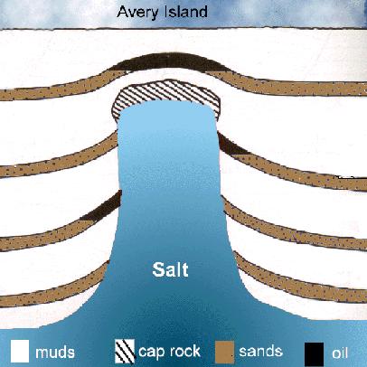
SALT DOMES
A salt dome is a
type of structural dome formed when a thick bed of evaporite
minerals (mainly salt, or halite) found at depth intrudes
vertically into surrounding rock strata. Over time, the salt is
covered with sediment and becomes buried. Since the density of salt
is generally less than that of surrounding material, it has a
tendency to move upward toward the surface, forming large bulbous
domes, diapirs , sheets, pillars and other structures as it rises.
In cross section, these large domes may be anywhere from 1 to 10
kilometers across and extend as far down as 6.5 kilometers. One
example of an island formed by a salt dome is Avery Island in
Louisiana. At present ocean levels it is no longer surrounded by
the sea but it is surrounded by bayous on all
sides.
There are over 500
salt domes in the onshore and near offshore part of the northern
Gulf Coast region, and others occur in Mexico, Central America,
Cuba and under the GOM. Not truly islands, these marvels are
elevated mounds surrounded by Holocene coastal
marshes.
The five Louisiana
islands, arched up by rising salt stocks, are the only large
topographic hills in the swamp, marsh and coastal plains of
southern Louisiana and were a conscript habitation for prehistoric
Indians and later European settlers. Geologists believe these
mysterious elevations were created when a saltwater ocean covering
what is now Texas, Louisiana and Mississippi evaporated, leaving
behind a vast sheet of salt. The salt was formed in a narrow sea
that existed during an early stage in the breakup of the
supercontinent Pangea, more than 200 million years ago. Over time
this salt layer was covered by thousands of feet of alluvial
sediment, the pressure of which pushed numerous salt domes straight
up.

In five places these
domes actually pushed up the topography.Today, these five coastal
islands sit above and are surrounded by the drab, yet strangely
exquisite swamps and marshes of south Louisiana. The islands
(Avery, Weeks, Côte Blanche, Belle Isle and Jefferson) are circular
topographic prominences from one to two miles in diameter, rising
75 feet or more above the surrounding marshlands. Avery Island
stands the highest at 152 feet above sea
level.

History of Avery Island
Long before its namesake Avery family
settled there in the 1830s, American Indians discovered that Avery
Island’s verdant flora covered a precious natural
resource—a massive salt dome. There the Indians boiled the
Island’s briny spring water to extract salt, which they
traded to other tribes as far away as central Texas, Arkansas, and
Ohio.
According to records maintained prior to
1999 in the Southern Historical Collection at University of North
Carolina at Chapel Hill,[2] Petite Anse Island, renamed Avery
Island in the late 19th century, was purchased by John Craig Marsh
of New Jersey in 1818. Besides mining salt, Marsh operated a sugar
plantation on the island's fertile soil. A daughter, Sarah Craig
Marsh, married Daniel Dudley Avery in 1837, thus uniting the Marsh
and Avery families. Daniel Dudley Avery hailed from Baton Rouge,
Louisiana, and was a jurist. In 1849, Daniel became co-owner of his
inlaw's sugar plantation and salt mines, and in 1855 he became sole
owner.

Just prior to the Civil War, Edmund
McIlhenny joined the Avery family by wedding Mary Eliza Avery,
daughter of Daniel Dudley Avery and Sarah Marsh Avery. After
fighting in the Civil War, Edmund McIlhenny returned to his Avery
Island plantation to find that not much had survived. The salt
works on this Gulf Coast Island were inoperable. The sugarcane
fields had been destroyed. But Mr. McIlhenny was delighted to find
that the special red peppers he had planted in his garden before
the war had miraculously survived. He began to experiment with
making pepper sauce, and eventually hit upon a formula that worked
by crushing the ripest, reddest peppers, mixing half a cup of local
salt with each gallon, then aging the mixture in crockery jars for
thirty days. He added fine French wine vinegar, and aged the sauce
for another thirty days before straining and bottling it. He chose
a Central American Indian name for the product, "Tabasco", and
shipped the first batch of 350 bottles in 1868. The hot sauce took
off like wildfire, and orders came in faster than they could be
filled. Tabasco has since become the definitive seasoning sauce,
offering people around the world a taste of south Louisiana. Just a
few drops helps to accentuate the flavor in foods. Some folks
wouldn't dare eat eggs without a dash of Tabasco and it is a vital
additive to many recipes, including Bloody
Marys.
 To log this earthcache, please
do the following:
To log this earthcache, please
do the following:
1. Optional: We
recommend that you post a picture with you and/or your GPS in the
background with the Jungle Gardens gift shop in the
background.
2. Required: Email the
cache owner with answers to the following
questions:
(A) At what depth was
the salt deposit discovered at in 1862?
(B) On what date were the salt works destroyed by the Union
Army?
(C) Avery Island reaches a total maximum elevation of 152 feet
above sea level. What is the elevation at the listed coordinates?
Take an elevation reading from your GPS at the listed coordinates
and email it to the cache
owner.

To learn more about earthcaches, including how to develop
one of your own click here Earthcache.org. You can also
obtain one or more of the following levels of the Earthcache
Masters
Program:
BRONZE (log three or more earthcaches in at least two or
more
states/countries),
SILVER (log six or more earthcaches in at least three or
more states/countries and develop one
earthcache),
GOLD (log twelve or more earthcaches in at least four or
more states/countries and develop two earthcaches),
or
PLATINUM (log twenty or more earthcaches in at least five
or more states/countries and develop three
earthcaches).