
 Overview
Mature rivers flow across wide river valleys and meander (or
"snake") across flat plains. I-70 in this area traverses through
the flat river plain created by the Smoky Hill, Republican, and
Kansas Rivers. In this area, the plain is distinctively flanked by
limestone bluffs (see nearby Earthcache "Kansas River Bluffs" for
more information). These meandering rivers create large loop
meanders that can eventually develop into oxbow lakes adjacent to
the active river flow.
Oxbow Creation, Step
1
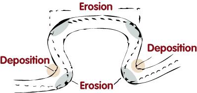
As a mature river begins to curve, it cuts and erodes into the
outside of the curve (known as the "concave" bank) and deposits
sediment on the inside of the curve (known as the "convex" bank).
This is due to the fact that the river moves more rapidly on the
outside of the curve and more slowly on the inside of the curve.
Thus, as the erosion and deposition continues, the curve becomes
larger and more circular.
Another depositional feature is a Point Bar or Towhead, and are
found in abundance in mature or meandering streams such as the
Smoky Hill River flows in this immediate area. The bars (also
popularly known as "sandbars") are crescent-shaped and located on
the inside of a river bend. Normally composed of sediment that is
well sorted and typically reflects the overall capacity of the
river. The bars also have a very gentle slope and an elevation very
close to water level. Since they are low-lying, they are often
overtaken by floods and can accumulate driftwood and other debris
during times of high water levels.
Oxbow Creation, Step 2
After time, the loop of the curve reaches a diameter of
approximately five times the width of the river, then the river
begins to cut the loop off by eroding the neck of the loop.
Eventually, the river breaks through at a cutoff and forms a new
riverbed.

Oxbow Creation, Step 3
Sediment is then deposited on the loop side of the river,
cutting off the loop from the active river entirely. This results
in a crescent-shaped lake that looks exactly like an abandoned
river meander. Such lakes are called oxbow lakes because they look
like the bow part of the yoke used with teams of oxen.

Logging
requirements:
Send the cache owner a note (click on "A Cache by Jeep_Dog" link)
with :
- The text "Smoky Hill Oxbow" on the first line and the number of
people in your group.
- From the first point (listed coordinates), as you look west,
what old and prominent depositional river feature do you observe?
Why does this feature occur here?
- From the second coordinates point, what do you observe on the
concave bank? Why do you think these were placed?
- From the third coordinates point, what do you estimate the
average depth of the oxbow lake to be?
- Request, but not a requirement (and can be helpful if any
answers for above question are incorrect): for additional
verification to avoid armchair logs, please include with your
online log a photo of your group with GPS at the cache
location.
The above information was compiled from the following
sources:
Hickin, Edward J. (2003). "Meandering
Channels". in Middleton, Gerard V.. Encyclopedia of Sediments and
Sedimentary Rocks.New York: Springer. p. 432.
Journal of Geophysical Research - Oceans. 2002.
http://www.agu.org/pubs/crossref/2002/2001JC001082.shtml.
"Secondary circulation in a region of flow curvature: Relationship
with tidal forcing and river discharge". Retrieved
2010-01-28.
Merriam–Webster.
http://www.m-w.com/cgi-bin/dictionary?book=Dictionary&va=oxbow.
"Oxbow".Retrieved 2010-01-28