To protect the delicate ecosystem around the base of the falls, as well as your personal safety, please stay behind the guardrail and fences and enjoy the falls from above. Do not attempt to hike to either the base of the falls or the top of the falls. Douthat State Park rangers regularly stop here, and you will be charged with trespassing if you are caught.

Falling Spring Falls has been drawing visitors for hundreds of years. In his 1781 manuscript, Notes on the State of Virginia, Thomas Jefferson wrote, "The only remarkable Cascade in this country, is that of the Falling Spring in Augusta. It is a water of James river, where it is called Jackson's river, rising in the warm spring mountains about twenty miles South West of the warm spring, and flowing into that valley."
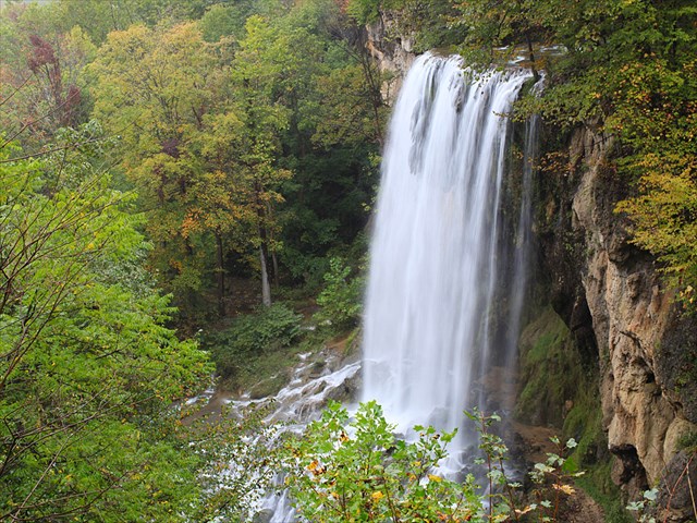
The stream rises in Warm River Cave, located on private property about a mile away. The water at its source, a mixture of warm thermal spring water and cold ground water, is approximately 85 degrees Farenheit year round and is rich in carbonates, mostly calcium carbonate. Scientists have theorized that the spring's water is heated by a pluton, an underground intrusion of igneous rock that formed around 2 million years ago in the Tertiary period and has been slowly cooling off since. As the stream flows out of the cave, it releases carbon dioxide, causing the water to become supersaturated with carbonate. When the stream spills over the ledge at Falling Spring Falls, even more carbon dioxide is released, and the carbonate precipitates and is deposited as a type of limestone called travertine. You can see how the travertine has formed on the cliff edge, like dripstone in a cave, as well as the terraces that have formed in the streams below. The beautiful, fragile terraces of travertine below the falls are visible from the overlook. The travertine crystals that precipitate out of the spring water accumulate on older travertine deposits, other sandstone rocks, and even sticks, gradually building up over time.
The lush greenery at the bottom of the falls is called a spray cliff community, a microhabitat that is hydrated by the spray generated by the waterfall. Spray cliff communities only occur on rock surfaces that are constantly wet. Few waterfalls in Virginia are both large and constantly flowing enough to sustain spray cliff communities, making the spray cliff community here a rare example of this delicate microhabitat. At least 14 different of bryophyte (moss) species thrive in the cliff walls behind and around the falls, and there may be up to 268 species at the falls.
Here's a photo from the base of the falls I found on a Virginia State Parks website, so you can see what it looks like down there without climbing down:
Photo by Dean Walton, courtesy of the Virginia Department of Conservation & Recreation
Beginning in 1914, mining companies acquired the land and began mining the travertine. Although the waterfall was much higher in its original location, mining operations diverted the flow to its present location, where the falls drop approximately 80 feet. The mining companies also used the falls to generate hydroelectric power in order to run a plant to process the travertine and an electric railway to haul it away.
In 2004, the falls and the 19 acres of land around it were donated to the Virginia Department of Conservation and Recreation. Today the falls are administered by Douthat State Park.
LOGGING THIS EARTHCACHE
To log this earthcache, email us or send us a message and copy and paste these questions, along with your answers. Please do not post the answers in your log, even if encrypted. There's no need to wait for confirmation from us before you log, but we will email you back if you include your email address in the message. Group answers are fine; just let us know who was with you.
1. The name of this earthcache: Falling Spring Falls Earthcache.
2. From the signs at the parking area and the overlook:
(a) How tall was the waterfall when Jefferson visited it?
(b) What was the travertine mined for?
3. Look down at the travertine terraces at the base of the falls.
(a) Describe what you see: how does the travertine rock look different from the rocks that form the wall at the overlook?
(b) Explain: how did the travertine form?
4. Add a photo to your "found it" log, taken from the overlook with the falls in the background, of yourself and/or a personal item, such as a GPSr, personal trackable, or even a piece of paper with your geocaching name on it.
There is a historical marker in the area with some history about "Mad" Anne Bailey, who had a cabin near here. Look just north of the parking area on the east side of US 220.
PLEASE DO NOT ATTEMPT TO CLIMB DOWN TO THE BASE OF THE FALLS. There is no need to leave the parking area or overlook to log this cache. There is no marked trail to the bottom of the falls, and the descent is very steep, rocky, and dangerous. The rocks are covered in moss and are very slippery. The travertine deposits and the spray cliff community microhabitat are rare and delicate, and Virginia State Parks wants you to stay away to preserve them for everyone. And you can be charged with trespassing. Hopefully that's enough reasons, SO: please enjoy the view from the overlook only.
Sources:
Thomas Jefferson, Notes on the State of Virginia (1781)
Richard Decchio and Dean Walton, The Falling Springs of Virginia (2003)
Janet Herman and Michelle Lorah, Groundwater Geochemistry in Warm River Cave, Virginia (1986)
Kristin O. Dennen, Richard J. Diecchio, and Mark A. Stephenson, "The Geology of the Falling Spring Travertine Deposit, Alleghany County, Virginia." Virginia Division of Minderal Resources Publication 101: Travertine-Marl: Stream Deposits in Virginia, Janet Herman and and David A. Hubbard, eds. (1990) < /br> Edward Beyer, Album of Virginia; or Illustration of the Old Dominion (1858) < /br>
There's a waymark at the falls, too!
This earthcache was placed with permission of Douthat State Park administrators.