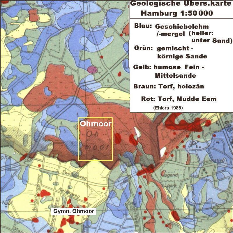
Ohemoor
Das Ohmoor ist eine Rest -
Moorfläche (von ursprünglich 450 Hektar sind noch 40
Hektar geblieben), die nördlich der Hamburger Staatsgrenze auf
Schleswig-Holsteinischem Gebiet erhalten geblieben ist. Im
zuständigen Planungsamt der Stadt Norderstedt wird die
Fläche auch nach dem traditionellen Namen
mit Ohemoor
benannt.
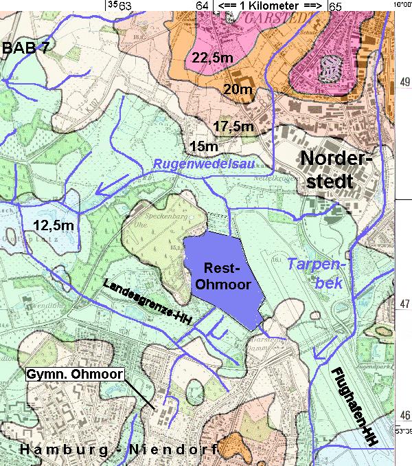
Ursprünglich hatte das
Moor eher die 10-fache Ausdehnung. Auf Hamburger Gebiet wurde es
seit dem 19. Jahrhundert vollständig abgetorft oder musste der
Siedlungsfläche des Stadtteiles Niendorf und den
Flughafen-Erweiterungen weichen.
Das Restmoor liegt an einer
schlechter entwässerbaren Stelle. Sein Niveau von 14mNN
hat nur nach Südwesten und Norden ein leichtes Gefälle.
Bei der Kultivierung wurden in diese Richtungen Entwässerungs-
gräben gezogen. Das Wasser gelangt über die Rugenwedelsau
nach Westen zur Pinnau und von dort in die Elbe.
Hochmoore werden
auch als Armmoor oder Regenmoor bezeichnet. Sie sind
ausschließlich regenwasserernährt (ombrotroph) und damit
sauer und sehr nährstoffarm (oligotroph). Sie verfügen
über nur geringe Gehalte an Stickstoff und anderen
Nährstoffe und zeichnen sich durch hohe
Kohlenstoffgehalte im Torf aus. Die pH-Werte liegen zwischen
3 und 4,8. Die typische Pflanzenwelt besteht aus fast geschlossenen
Torfmoorrasen (Klasse: Oxycocco Sphagnetea). Diese
nährstoffarmen Standorte findet man großflächig in
allen Regenmooren, kleinflächig in Kesselmoorzentren und sehr
kleinflächig auch in den Übergangsbereichen
mineralbodenwasser ernährter Regenmoore. Hochmoore entwickeln
sich häufig auf Niedermooren aber auch ohne vorherige
Niedermoorbildung direkt auf mineralischem Untergrund (wurzelechte
Hochmoore). Regenmoore lassen sich auch hinsichtlich der
ökologischen Bedingungen relativ klar von allen anderen
Moortypen abgrenzen. Die extreme Nährstoffarmut, der niedrige
pH-Wert und die permanente Wassersättigung der
Hochmoorlebensräume bedingen eine hochspezialisierte
einzigartige Flora und Fauna mit einer Vielzahl gefährdeter
Arten.
| Um diesen EarthCache
zu loggen beantworte bitte folgende Fragen:
1. Wie alt
ist das Ohemoor?
2. Wie
viele Libellenarten wurden im Ohemoor nachgewiesen?
3. Wie
entsteht Torf?
4. Mache
von Dir und/oder Deinem GPS ein Foto an folgenden Koordinaten:
N 53° 39.301 E
009° 58.182
|
Du darfst diesen EarthCache mit
Beantwortung der Fragen per eMail und dem Einstellen des Fotos
gleich loggen. Sollten Deine Antworten falsch sein, melden wir
uns!
ENGLISH-VERSION
Ohemoor
The Ohmoor is a rest - moorland
(from an initial 450 hectares just 40 acres left), which has been
preserved to the north of Hamburg's state border to
Schleswig-Holstein area. The relevant planning authority
of the city is named, the Norderstedt area even after the
traditional name with Ohemoor.
Originally, the marsh had more
the 10-fold expansion. At Hamburg area, it has been
since the 19th Century, or had completely
abgetorft Niendorf and municipal part of the settlement area of the
airport soft extensions.
The Restmoor is due to a poor
dewatering site. His level of 14mNN southwest
and north, has only a slight incline. When was the cultivation in
these directions drainage ditches drawn. The water passes through the
Rugenwedelsau west to the Ministry's and from there into the
Elbe.
Bogs are also known as Armmoor
or Regenmoor. You are solely
regenwasserernährt (ombrotroph) and thus very acidic and
nutrient poor (oligotrophic). They have only small amounts of
nitrogen and other nutrients and are characterized by high carbon
content in the peat. The pH values are between 3 and
4.8. The typical vegetation consists
almost closed Torfmoorrasen (class: Oxycocco Sphagnetea).
This nutrient-poor sites are
found extensively in all the rain, bogs, small areas in
Kesselmoorzentren nourished and very small areas in the transition
areas mineral soil water rain Moore. Bogs to fens, however, often
develop directly) without prior Niedermoorbildung on a mineral
substrate (ungrafted bogs. Rain Moore can also be
distinguished on the environmental conditions relatively clear of
all other mire types. The extreme nutrient poverty,
the low pH and the permanent water saturation of the peat bog
habitats require a highly unique flora and fauna with a variety of
endangered species.
To log
these EarthCache a photo of you or your GPS provides please in the
Lore and answers please the following questions:
1.
How old is the Ohemoor?
2. How many species of dragonflies
have been found in Ohemoor?
3. How is peat?
4. Make of yourself and / or your
GPS a photo at the following coordinates:
N 53 ° 39,301 E 009 °
58,182
You can cache this Earth with
answering questions via email and set the same log photos.
Should your answers be wrong,
we will contact you!