27 A Walk in the Garden- The Tonduffs Multi-Cache
27 A Walk in the Garden- The Tonduffs
-
Difficulty:
-

-
Terrain:
-

Size:  (regular)
Please note Use of geocaching.com services is subject to the terms and conditions
in our disclaimer.

Visit The Geocaching Ireland discussion
forum HERE
A wind, bringing willow cotton, sweetens the
shop,
And a girl from Wu, pouring wine, urges me to share it.
With my comrades of the city who are here to see me off;
And as each of them drains his cup, I say to him in parting,
Oh, go and ask this river running to the east
If it can travel farther than a friend's love!
(Li Po)
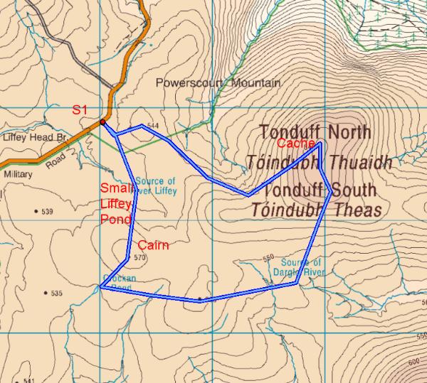
A shortish, if boggy stroll in the Garden County which takes in the
North and South Tonduffs and for good measure, the source of
Dublin's River Liffey and that of the River Dargle. The walk, at
its max (using the route illustrated above which you are not
obliged to do to reach the cache), is approx 8K with a total
incline of 260m, most of which is negotiating small peat hags and
some rough and lumpy open terrain.
There is room for one or two cars at Stage 1 at N53 09.818 W006
17.719. Here you will find a small sign with information on the
front and back of it. On the back (or Tonduff) side you will find a
small declaration given in English and in Irish. Leaving out the
small writing at the bottom count all the LETTERS in the Irish
section, call this AB. Now take the fourth line of the poem above
and count the WORDS in it, call this CD.
The final cache is close to the summit of Tonduff North at N53
09.(AB X CD) -9 W006 16.(AB X 3) -10
For those interested in a pleasant and interesting circular hike,
if you set off in the direction of the cairn that is visible to the
south rather than directly toward the cache, you will very shortly
meet the actual source of the River Liffey at N53 09.495 W006
16.245. At most times a small pond marks the spot.
Carrying on to that cairn at N53 09.165 W006 17.585 you will be
quite close to Crockan Pond (N53 09.025 W006 17.835). From there
you can head in an easterly direction for about 2K and you will
cross a small stream which is the source of the River Dargle. This
is at N53 09.025 W006 16.245.
From there it is a relatively easy uphill hike north to Tonduff
South first then on to the cache on Tonduff north.
It is worth noting this route as it is not only more interesting
but it also provides the gentlest means of approaching the final
cache though it is longer than the more direct route. While
ascending towards Tonduff North it is easiest by far to approach
via Tonduff South and my route achieves this.
You may notice plenty of larksong along the way which means you
will probably be very close to their nesting sites and they will be
letting you know!!
Do not start the trek without
all the proper mountain rain gear, waterproof boots and the
guidance material, compass, map, GPSr with mapping etc.
Please note that all parts of this cache are hiked at your own
risk. The cache owner takes no responsibility of any sort for any
reason including accidents or
mishaps.
Please be aware that cars parked
in areas close to walking trails are vulnerable and they can be
vandalised or stolen. Unfortunately this is an ongoing problem
which is extremely difficult to solve, so there is a risk involved.
I have heard recently that many hiker groups are parking at the
nearest population centres and getting taxis to and from the start
points at very little expense.
Please observe the country code to the best of your ability. Local
landowners often generously allow access to upland areas across or
through parts of their private property. Please, please be
conscious of this and return the courtesy by keeping all gates
closed, immediately and not on your way back!. Please use the gates
where appropriate but if you have to climb over them then use the
hinged side ONLY.
Please do not cause any damage of any sort to fences or barriers
along the way.
Additional Hints
(No hints available.)