
Spring
Spring, in geology, natural flow of
water from the ground or from rocks, representing an outlet for the
water that has accumulated in permeable rock strata underground.
Some of the water that falls as rain soaks into the soil and is
drawn downward by gravity to a depth where all openings and pore
spaces in the rock or soil have become completely saturated with
water. This region is called the zone of saturation, and the water
it holds, groundwater. The upper surface of the zone of saturation
is called the water table. Above the water table lies the zone of
aeration, where the pore spaces in the soil are quite dry and are
filled with air. When the upper surface of the groundwater (water
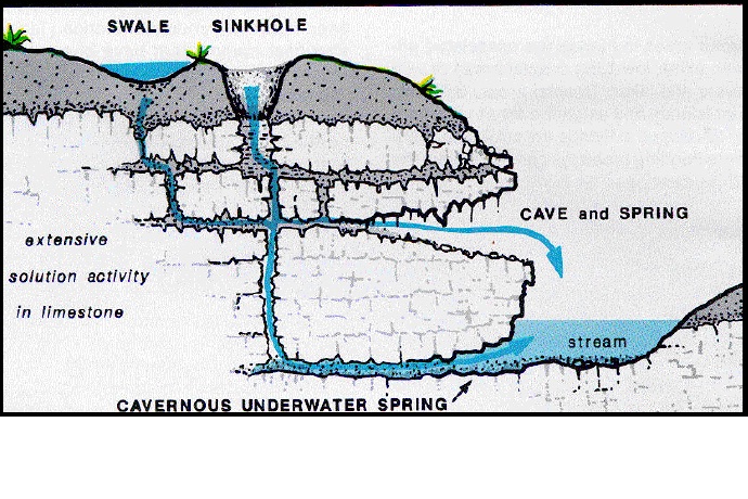
table) intersects a sloping land surface, a spring appears. The
occurrence of springs is closely related to the geology of an area.
If an impervious layer of rock, such as a clay deposit, underlies a
layer of saturated soil or rock, then a line of springs will tend
to appear on a slope where the clay layer outcrops. Igneous rocks
are also impervious to water, yet they are often extensively
fractured, and springs commonly appear where these fractures come
to the surface. Fractures in limestone are often enlarged by the
dissolving action of groundwater, forming small underground
channels and caves. Where these channels outcrop, springs are
likely to be found. Springs are common along major faults because
groundwater reaches the surface along the fault plane. Lines of
springs help locate the position of faults such as the San Andreas
of California. Springs can be a valuable water resource, and
improvement in flow can often be accomplished simply by driving a
pipe into the ground at the point where water seeps from the
ground. Sometimes it is advisable to divert the spring water into a
cistern or other storage reservoir from which the water can be
pumped at will. When the water, because of the geological structure
of the strata, issues under pressure, the spring is called
artesian. Another type of spring is the geyser. Hot springs occur
when the water issues from great depths or is heated by
near-surface hot volcanic rock, as in Yellowstone National Park,
Iceland, and New Zealand. Mineral springs are those with a high
mineral content, usually silica or lime, dissolved from the rocks
through which the water has passed. Many ancient city-states, such
as Troy, had their sites determined by springs. Pioneer farmhouses
often were located in the same way. Columbia Encyclopedia:
Spring
Classification
Springs are often classified by the volume of the water they
discharge. The largest springs are called "first-magnitude,"
defined as springs that discharge water at a rate of at least 2800
liters or 100 cubic feet (2.8 m3) of water per
second. Some locations contain many first-magnitude springs, such
as Central Florida
where there are 33[2] known to be
that size, the southern Missouri Ozarks (11 known of
first-magnitude), and 11[3] more in the
Thousand Springs area along the Snake River in
Idaho. The scale for
spring flow is as follows:
| Magnitude |
Flow (ft³/s, gal/min, pint/min) |
Flow (L/s) |
| 1st Magnitude |
> 100 ft³/s |
2800 L/s |
| 2nd Magnitude |
10 to 100 ft³/s |
280 to 2800 L/s |
| 3rd Magnitude |
1 to 10 ft³/s |
28 to 280 L/s |
| 4th Magnitude |
100 US gal/min to 1 ft³/s (448 US gal/min) |
6.3 to 28 L/s |
| 5th Magnitude |
10 to 100 gal/min |
0.63 to 6.3 L/s |
| 6th Magnitude |
1 to 10 gal/min |
63 to 630 mL/s |
| 7th Magnitude |
1 pint to 1 gal/min |
8 to 63 mL/s |
| 8th Magnitude |
Less than 1 pint/min |
8 mL/s |
| 0 Magnitude |
no flow (sites of past/historic flow) |
Wikipedia.com: Spring (hydrosophere)
Using this chart and some crude estimates and calculations I
believe that the Southern Springs spring head is a 5th magnitude
spring, but it is very close to a 4th magnitude!

Read an excellent article entitled
The Science of Springs
Southern Springs
The area around this artesian spring has been an important
recreation and picnic area to the local people for more than 100
years. Families would walk pulling their wagon with food and
children to enjoy the natural resources this area has to offer.
With its cool air, water crest and ice cold pristine water it was
and still is the best place to enjoy a hot summer day. In 1895, the
Southern Railroad built through this area and it has since been
named Southern Springs by the community. The remains of trestle
supports can still be seen in the stream. You will definitely enjoy
your visit to Southern Springs and it is still a perfect place for
a picnic when the weather is good. Afterwards, you can take a walk
on the Chief Ladiga Trail, a rails to trails project that is only a
few feet from the spring.
The cache
To get credit for this cache. Please take a picture and post it
with your log. There are no exact requirements for this picture,
just have fun and be creative!
Next, I would like for you to calculate the feet per second
(fps) that the stream coming from the spring head is moving. From
the spring head to the point where the flow joins the creek, near
the bridge is approximately 60 feet. You will need to find
something organic, such as a twig or leaf (please do not use
anything like trash, practice C.I.T.O.) that will float, and drop
it into the flow in front of the spring head. Now time the floater
until it gets to the place where the spring flow dumps into the
creek. Divide the number of feet (60) by the number of seconds it
takes for the floater to reach the creek, and that will give you
the feet per second (fps) that the spring is flowing. Email the fps
to me at the link above.
Also, you can use this information to help you calculate the
approximate flow volume of the spring, by estimating the size of
the springhead in cubic feet and multiplying that by the speed
(fps) of the water. Include the volume in your email.
Lastly, tell me the magnitude of the spring based on the
information above.
Please do not list any spoiler information in your log, and
please send me your information and post your picture within 48
hours of logging the cache.
HAPPY TRAILS!!!