Dragsåsen Earthcache
Välkommen till Dragsåsen Earthcache!
Dragåsen är en Getryggsås som skapades under den senaste istiden.
Åsen är ett natturreservat så var extra rädd om naturen.

Den senaste Istiden
För ungefär 70 000 år sedan började indlandsisen breda ut sig över Sverige och Skandinavien. Isen hade sin maximala utbredning för ca 22 000 år sedan då den nådde delar av Jylland, norra Tyskland och norra Polen.
När klimatet så småningom blev varmare började isen smälta och för ungefär 16 000 år sedan låg iskanten vid Skånes sydkust. Isen smälte sedan undan för undan men tillbakagången var ryckig och varma perioder med kraftig avsmältning växlade med kalla perioder och långsammare tillbakagång av isen. Issjöar bildades av smältvatten som dämdes upp mellan iskanten och det sydsvenska höglandet, som då var rejält nerpressat av isens tyngd. Det är resterna av dessa gigantsika issjöar som idag bildar alla de sjöar som finns i Småland söder om det sydsvenska höglandet.
Värendsfornsjsön
De stora sjöarna som vi ser i Kronobergs län idag härstammar från en stor issjö som brukar kallas för Värendsfornsjön.
När isen drog sig tillbaka rann smältvattnet ut i den stora issjön som innefattade sjöarna Åsnen, Salen, Helgasjön och slätten däromkring.
Smältvattnet rann i stora älvar på och genom tunnlar under isen för att sedan rinna ut i sjön där det avsatte finkornigt, näringsrikt material på sjöbotten.
När landmassan senare reste sig och sjöarna i Mörrumsån fick sina nuvarande stränder, bildades den bördiga fornsjöbotten som skapade förutsättningarna för länets största jordbruksbygd som ligger just mellan Helgasjön och Åsnen.
Jordarna söder och sydväst om Åsnen är däremot lika magra som på andra håll i länets skogsbygder.
Rullstensåsarna
När inlandsisen smälte bildades stora mängder vatten som forsade fram på, i och under isen. Dessa jättelika isälvar följde ofta dalgångarna i berggrunden. Det strömmande vattnet i isälvarna tog med sig stora mängder löst material, stenar, grus, sand m.m. när det forsade fram under isen. När vattnet närmade sig iskanten minskade strömhastigheten och vattnets transportförmåga och materialet började sjunka mot botten.
Först sjönk de större stenarna och blocken medan det finare gruset följde med vattnet längre från tunnelöppningen. På så vis skapades rullstenåsar som alltså har grova stenar djupt ner och fint grus högre upp i åsen. Under färden då block och stenar forsade fram i isälvarna nöttes de av strömmarna och rundades till rullstenar, därav namnet rullstensås.
Om tunneln mynnade ovanför vattenytan eller på land blev rullstensåsarna toppigare. Detta för att det översta gruslagret rasade ned utför kanterna. Sådana rullstensåsar kallar vi getryggar eller getryggsåsar.
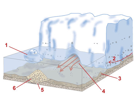
1. Isberg 2. Isens rörelserikting 3. Material som isen avsätter (Morän)
4. Isälv 5. Dalgång i berggrunden 6. Rullstensås
I området runt Växjö finns det flera stora rullstensåsar som vittnar om isens tillbakagång. Bland annat den långa Växjöåsen som går rakt genom Helgasjön vid Jägaregap och vidare genom Kronobergshalvön där den kallas för Evedalsåsen.
Den ås som den här earthcachen behandlar kallas för Dragsåsen och är den del av Bergundaåsen som även den går genom Helgasjön och sen nästan rakt söderut genom Bergundasjöarna för att sedan gå längs Åsnens östra strand genom Jät och ända ner till sjön Mien.
För att logga:
1. Följ åsens krön från parkeringen och ut till slutkoordinaten. Notera hur åsens höjd varierar längs stigen, varför gör den det? Maila cacheägaren och berätta varför höjden på en rullstensås varierar utefter dess sträckning.
2. Använd en karta för att följa åsen söderut i landskapet. Maila cacheägaren namnet på någon ö som skapats genom att Bergundaåsen sticker upp ovanför vattenytan. Det finns flera bra exempel både i Helgasjön och Norra Bergundasjön.
Frivilligt: Ta ett foto på dig och din gps vid bänken vid cachekoordinaten, längst ut på åsen.
Du behöver inte vänta på mailsvar för att få logga men loggar som inte har försökt svara på frågorna kommer att raderas
Lycka till!

Welcome to Dragsåsen Earth Cache!
Dragsåsens is an esker created during the last ice age.
The esker is a nature reserve so please be extra careful with nature.
The Ice Age
About 70 000 years ago the ice began to grow over Sweden and Scandinavia. The ice sheet was at its maximum size about 22 000 years ago.
By then, the edge of the ice sheet had reached parts of Jylland and the northern parts of Germany and Poland.
As the climate gradually became warmer, the ice began to melt and about 16 000 years ago, the iceedge was at the south coast of Skåne.
When the ice melted the climate changed gradually and the decline got irregular when warm periods with fast melting alternated with cold periods and a slower decline of the ice.
Ice lakes were formed by the meltwater, which was dammed up between the ice edge and the south swedish highlands, which were then significantly lowered by the iceload.
The lakes in the area are remains of these gigantic icelakes.
Värendsfornsjsön
The big lakes that are to be seen in Kronoberg County originate from a large icelake called Värendsfornsjsön (The Ancient Lake of Värend).
When the ice retreated, meltwater flowed into the large icelake that covered the lakes Åsnen, Salen, Helgasjön and the plains between those lakes.
The meltwater flowed in icerivers through and under the ice and further on into the lake where it dropped fine-grained, nutrient-rich material on the seabed.
Today, when the land has risen again those areas between Helgasjön and Åsnen are the county's largest agricultural district, all due to the fertile ancient lakebed.
Soils south and southwest of Åsnen on other hand, is just as lean as elsewhere in the county's woodlands.
Eskers
When the ice melted, large amounts was set free and created large icerivers. These giant ice-rivers often followed the bedrock valleys. The flowing water in the ice-river carried large amounts of loose material, stones, gravel, sand, etc. when it surged forward under the ice. As the water approached the edge of the ice the flow decreased and the materials began to sink to the bottom.
The larger stones and blocks sank first, while the finer gravel followed the water farther away from the tunnel opening. Thus generated eskers which therefore has rough stones deep in the ridge and finer gravel higher up.
The sharp edged eskers as we see example of here on Dragsåsen was created when the icetunnel ended above the waterlevel instead of under it.
When the water flooded out from the tunnel the gravel layer at the top tumbeled down the sides of the esker, creating a peak at the top.
This type of a ridge is called a "goat back ridge" because the crest is pointy. And, from a distance, it looks like, a coarse goat back.
1. Iceberg 2. Movement direction of the ice 3. Glacial till
4. Watertunnel 5. Valley 6. Esker
In the area around Växjö, there are several large eskers that bear witness to the last iceage and its retreat. Among others, the long "Växjöåsen" that goes straight through Helgasjön at Jägaregap and on through the Kronoberg Peninsula where it is called "Evedalsåsen".
This earth cache addresses an esker called Dragsåsen which is a part of "Bergundaåsen". Bergundaåsen also passes Helgasjön and then reaches south through Bergundasjöarna (Bergunda Lakes) and then along the eastern shore of the lake Åsnen, and all the way down to the lake Mien close to the Blekinge border.
How to log:
1. Follow the esker from the parking lot out to the final coordinate. Note how the ridge height varies along the path, why is it so?
Email the cache owner and explain why the height of an esker varies along its route.
2. Use a map to follow the ridge to the south. Email the cache owner the name of one of the islands created due to the eskers top showing up above the water.
There are several good examples in both Helgasjön the two Bergunda lakes.
Optional: Take a photo of yourself and your gps at the bench by the cachecoordinates.
You dont need to wait for the cacheowner to mail back before you can log the cache, but any logs that doesn't try to answer the questions will be deleted.
Good Luck!
 The most exciting way to learn about the Earth and its processes is to get into the outdoors and experience it first-hand. Visiting an Earthcache is a great outdoor activity the whole family can enjoy. An Earthcache is a special place that people can visit to learn about a unique geoscience feature or aspect of our Earth. Earthcaches include a set of educational notes and the details about where to find the location (latitude and longitude). Visitors to Earthcaches can see how our planet has been shaped by geological processes, how we manage the resources and how scientists gather evidence to learn about the Earth. To find out more click HERE.