
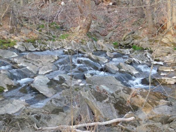
This is where the Boonesborough Fault Line is visible. The photo
on the left is what you will see. The photo on the right is where
the Boonesborough Fault crosses Two Mile Creek a couple of miles
from here; the normally flat creekbed is turned up on its edge.
In geology, a fault is a planar fracture in rock in which the
rock on one side of the fracture has moved with respect to the rock
on the other side. A fault line is the surface trace of a fault,
the line of intersection between the fault plane and the Earth's
surface.
Large faults within the Earth's crust are the result of
differential or shear motion and active fault zones are the causal
locations of most earthquakes. Earthquakes are caused by energy
release during rapid slippage along a fault. The Boonsborough Fault
is considered an inactive fault.
Since faults do not usually consist of a single, clean fracture,
the term fault zone is used when referring to the zone of complex
deformation that is associated with the fault plane. The two sides
of a non-vertical fault are called the hanging wall and footwall.
By definition, the hanging wall occurs above the fault and the
footwall occurs below the fault. This terminology comes from
mining. When working a tabular ore body the miner stood with the
footwall under his feet and with the hanging wall hanging above
him. Faults can be categorized into three groups based on the sense
of slip. A fault where the relative movement (or slip) on the fault
plane is approximately vertical is known as a dip-slip fault. Where
the slip is approximately horizontal, the fault is known as a
transcurrent or strike-slip fault. An oblique-slip fault has
non-zero components of both strike and dip slip.
In addition to vertical stresses shown by the normal faulting,
horizontal compression is indicated by nearly vertical shear joints
in conjugate sets. These joints are best developed in dolostone
beds. They are commonly smooth and many have horizontal
corrugations. They suggest that at one time the maximum shear
stress was horizontal and that the intermediate axis of the stress
ellipsoid was vertical.
For all naming distinctions, it is the orientation of the net
dip and sense of slip of the fault which must be considered, not
the present-day orientation, which may have been altered by local
or regional folding or tilting.
The Boonesborough fault is normal, dips about 75° S.,and has
brought steeply dipping Lexington Limestone (possibly the middle
tongue of the Tanglewood) against the lower part of the Oregon
Formation and upper part of the Camp Nelson Limestone. Several
minor steeply dipping synthetic and antithetic normal faults can be
seen in outcrops north of the main fault.
To get credit for finding this earthcache please email me (do
not post the answer when logging this cache)
1. Which of the three groups of faults is represented here.
2. The type of road sign that is about 50 feet to your immediate
left when viewing this earthcache.
You can go ahead and log your find but logs might be deleted if
the answers to the questions are not emailed to me. Posting a photo
of yourself in front of the earthcache is encouraged, but is not
required.
