Sapa Ancient Rock Field is an area about 8 sq.km amongst the terraced rice paddies in Muong Hoa Valley approximately 12km southeast of Sapa town in Hau Thao Commune.
The first exploration research, in 1925, recorded that there were 200 stones of various dimensions concentrated in the area. Hon Bo, which is 15m long and 6m high, is the biggest of theses rocks. The engravings on the surfaces of the stone are either pictographic or decorative.
Remarkably, among the engravings are drawings of humans, stilt-houses of the ethnic minorities and symbols believed to be a primitive form of writing. But their meaning has not yet been deciphered.
In addition, impressive images include a da chong (the husband stone), da vo (the wife stone), as well as stones that look like tigers and a Stella with an incantation written on it by the carver to help his people defeat the tigers.
Archaeologists have proven that this area has been inhabited since ancient times. These fascinating Viet remains have drawn the attention of scientists and tourists.
The "Area of Old Carved Stone in Sapa" is a Unecso world heritage. For more details about the area visit this link to the Unesco.
-- Geological features --
The Muong Hoa valley belogs to the Fansipan zone (Dovijikov A.E. et. al. 1995), which covers all the territory of Hoang Lien Son montain, stretching in the northwest-southwest direction from the Vietnam-China border to the catchment area of the Da river. The crystallized foundation of this zone, consisting of metamorphic rocks of the Neoproterozoic age, is unconformably covered by the folded rocks of the Paleozoic age, which is mainly composed of terrigenous sediments datinf from Cambrian to Devonian age.
At some places is found the covered layer of sedimentary-effusive rocks of Mesozoic age, which were intruded by granitoid bodies in different complexes. This zone has a block structure; the blocks were formed by different faults in a high grade. During the Proterozoic age, this zone subsided undifferentialy. During the Paleozoic age, the central part was uplifted, parts of the western rim and southern rim were subsided earlier; the part of the eastern rim was subsided later in the lower Devonian age. After that, the history of this zone was developed as an uplifted block. The magma activation and the strong tectonic movement happened during the Cretaceous-Paleogenic age, including the dynamic metamorphism of large faults.
The rocks in the Sapa area, including the Muong Hoa valley, belong to the Sapa group consiting of two formations: Cha Pa and Da Dinh. The main cross-selection is exposed at Km 2 to Km 7 along the Sapa-Lao Chai road, and along the path from Ta Phinh southward trough Km 32 Bridge. The rocks of Sapa groud are identified as belonging to the Neoproterozoic age:
Cha Pa formation: composed of qartz feldspar-mutscovite schist interbedded with mutscovite schist, quartz-mutscovite-scricite schist, gray quarzite; mutscovite schist interbedded with tremolite schist, talc-tremolite schist, calcite-mutscovite schist, thin bedded dolomite marble. The rocks of this formation are only distributed within the Fansipan structural zone.
Da Dinh formation: composed of fine to medium grained marble, containing tremolite, medium thick bedded, upper of them beiing fine coarse grained marble, white bedded to massive dolomite; white medium grained, massive to thick bedded dolomite marble intercalated with banded marble containing tremolite, muscovite, seapolite. This formation lies conformably on the Cha-Pa formation and is covered unconformably by the Cam Duong formation of the lower Cambrian age (Bui Phu My et al., 1968).
The age of the Cha Pa and the Da Dinh formations is Neoprotezoic corresponding to the Sini age of China.
The rocks of the Cambrian and Devonian ages are distributed at different elevations in Lao Cai Province and Sapa district.
-- The history of the formation and development of the Muong Hoa Valley --
From the lower Paleogenic Age (65.5 million years ago), the continental regime was established in the Lao Cai area; the activity of the tectonic mountaion building strongly happening at the same time of large magma intrusion destroyed the topographic map of this area to form the main frames of recent relief. During later Paleogene to the early Neogen (23.03 million years ago), it was a period of stable tectonic activity and complete leveling relief (peneplain). From the upper neogene (pliocene) up to now, due to strong neotectonic activity, the processes of vertical tectonic activity have formed the uplifted areas and subsided areas, the imcomplete leveling surfaces (pediment), the valleys and terraces of rivers and streams in this area, including Hoa spring.
The Muong Hoa Valley, with its bottom at the elevation of 1000m, is the result of endogenous processes such as tectonic, neotectonic and recent geodynamic activities. The active fault systems divided rocks of the Sapa group into blocks with diefferent strikes. The geological structure is the base to form the morphology of relief types. Based on these morphological reliefs, the exogenous processes such as climate, hydrology, the slide and weathering process forme the morphosculptures of relief types.
The Muong Hoa Valley belonging to the Fansipan zone was uplifted from Pliocene (5.332 million years ago), due to endogenous and exogenous processes. The relief type is a mid-mountain valley of erroded-accumulated genesis.
The carved boulders found in the Muong Hoa valley are sandstones with hundreds of bolders in different sizes, distributed at different elevations. According to Nguyen The Hiep (Hanoi 1990), more hidden carved patterns were found on Nuong Ngo boulder after the 20cm thick layer of soil around its foot and side had been cleaned off. At this position, it is very difficult to carve to lines of tiny dots connected to the two patches of carved dots in the upper layer. Therefore, it can be determined that these carved boulders were rolled down from higher positions of mountain around the valley. The carved boulders have been weathered by time. The rolling of these boulders may have been the result of ancient earthquakes in this region or the activity of fault systems. As the rocks of Sapa group have been fractured by the weathering process and tectonic activity, they are easily seperated and rolled to lower positions by rainy water and temporary streams thus forming the landscape of a carved rock field.
-- How to find the cache --
Following our description it should be easy to find your way to the rock we selected for this earthcache.
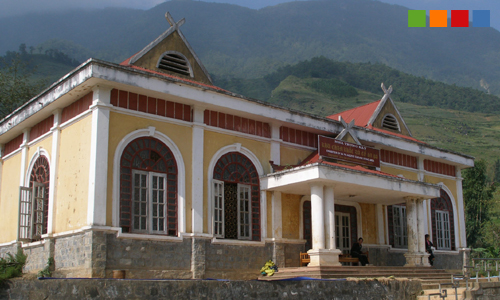
Drive from Sapa Town on the road 152 in southeast direction. About 10 kilometers from town you will find the building (see picture one - Nha Trung Bay) on the left hand. And - if you are lucky - the exhibion of the carving stone area is open.
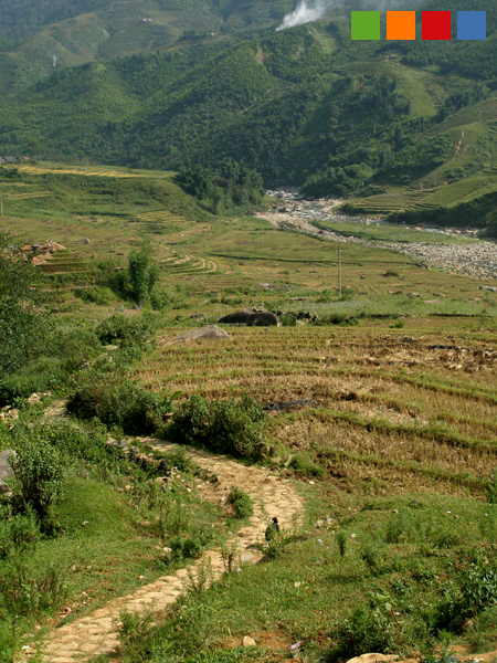
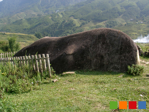
Stop here and take the small path (see picture two) to the mentioned rock (see picture three).

To log this cache, please send us an email or a message via geocaching with
a) the width and maximum height of the rock and
b) with your coordinates
and the answer of the following question:
c) What ist the altitude above sea level at the rock?
Please take a recognizable picture of you and your device in front of the marble rock.
Note: Please be mindful and don't climb on the rocks! If you like to, take a rubbing with charcoal and paper or take pictures. Good luck. We enjoyed the ancient rocks in October 2009 and hope, you will enjoy it, too.