THE RIVER THAMES - Rocks on the River Bed
First some general and geological information about the river:
The River Thames is the second longest river in the United Kingdom and the longest river entirely in England, rising at Thames Head in Gloucestershire, and flowing into the North Sea at the Thames Estuary. It has a special significance in flowing through London, although London only includes a short part of its course. The river is tidal in London with a rise and fall of 7 metres (23 ft) and becomes non-tidal at Teddington Lock.
The River Thames can first be identified as a discrete drainage line as early as 58 million years ago, in the late Palaeocene Period Thanetian Stage. Until around half a million years ago, the Thames flowed on its existing course through what is now Oxfordshire, before turning to the north east through Hertfordshire and East Anglia and reaching the North Sea near Ipswich. At this time the river system headwaters lay in the English West Midlands and may, at times, have received drainage from the North Wales Berwyn Mountains. Arrival of an ice sheet in the Quaternary Ice Age, about 450,000 years ago, dammed the river in Hertfordshire and caused it to be diverted onto its present course through London. This created a new river route aligned through Berkshire and on into London after which the river rejoined its original course in southern Essex, near the present River Blackwater estuary. Here it entered a substantial freshwater lake in the southern North Sea basin. The overspill of this lake caused the formation of the Dover Straits or Pas-de-Calais gap between Britain and France. Subsequent development led to the continuation of the course which the river follows at the present day.
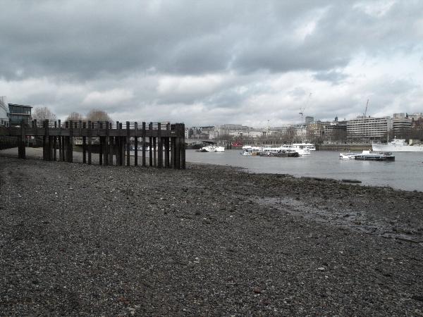
The River Thames and the river bed at low tide
Now to this earthcache:
Visit the river bed during low tide to find some very interesting rocks on the river bed. You can find public access to the river bed at the stairs at N 51° 30.505 W 000° 06.522. Prior to your visit you may want to check the tide times here…(visit link) (How it works: Look for Tower Pier and your date of visit. Then find the time of the lowest number.)
The rocks you are looking for (also referred to as "nodules") are everywhere!
These rocks were formed in the Jurassic period (about 199,6 to about 145,5 million years ago) and in the Cretaceous period of geology (about 145,5 to about 65,5 million years ago). During these periods most parts of the United Kingdom was lying beneath sea level.
From a petrological point of view, the name of the rock refers specifically to the form of chert which occurs in chalk or marly limestone. The exact mode of formation of this rock is not yet clear but it is thought that it occurs as a result of chemical changes in compressed sedimentary rock formations, during the process of diagenesis. One hypothesis is that a gelatinous material fills cavities in the sediment, such as holes bored by crustaceans or molluscs and that this becomes silicified. This theory certainly explains the complex shapes of the nodules that are found.
Millions of years later the rocks were part of the bed load of the River Thames and still are until today. The River Thames transports the rocks from upstream, especially from Oxfordshire, Berkshire, Buckinghamshire and Gloucestershire, and deposits them here on the river bed.
The rock is a hard, sedimentary cryptocrystalline form of the mineral quartz, categorized as a variety of chert. It occurs chiefly as nodules and masses in sedimentary rocks, such as chalks and limestones.
In the Stone Age these rocks were used to make tools or cutting edges. Examples of other uses are: to ignite fire or gunpowder; as building material; raw material for the ceramics industry.
To log this earthcache, you need to find one of the described rocks, examin it and answer the following question:
1. What is the name of the described rock that you can find here?
2. Describe color and appearance of the inside of the rock.
3. Describe color and appearance of the outside of the rock.
4. How do the rocks break, if you hit them against another rock?
To claim this earthcache as a find please send me an E-Mail with your answers, your caching name (eg erdnus) and your email address through my profil BEFORE YOU LOG. Afterwards you can log the cache as a find and upload your picture (preferably you with your GPS - with one of those rocks in your hand, if you like - or just your GPS at the location). Please do not reveal the answers in your log! You don't have to wait for my confirmation. I'll contact you if there is anything wrong with your answers.
Have fun!
erdnus
P. S. This cache is a “thank you” to the cachers of London. We really enjoyed your caches on our Easter weekend holiday in London!
Special thanks to rodz, Dorsetgal & GeoDog, Loony Londo, Firelanterns, goldpot, siloans, frozboz, heartstones1, 37251, currykev, morcheba, LeighBCD, ivymill, nihcuk, FantasticCat, MartyBartfast and last but not least to Q-Clan, who led us to this spot for our earthcache in the first place