Slovensko - Madarská štátna hranica má 654,8 km
, z toho 339km na vodných tokoch, 56.6km na hranicných cestách.
6.7km na hranicných priekopách a 252.6km priamym vyznacením.
Úcelom tejto série je predstavit vám zaujímave miesta tejto
štátnej hranice.
ENGLISH
The border area, which passes through the vertical border to the
surface and separates the territory of the Slovak Republic, its air
space, the space underneath the Earth's surface, elevated and
underground construction and equipment of all kinds from the
territory of neighboring countries.
Course of the border usually indicated:
* Directly - border signs planted in the fracture points
borderline
* Indirectly - border signs are planted outside the border line,
for example. on the sides of the border watercourses and the edges
of border roads and the deadline is determined by their axis
generally determined mathematically points
The national borders of the Slovak Republic are in the field signed
by border signs, usually from granite, andesite, concrete,
respectively other milestones. Their size provides a special
technical regulation issued by the Border Commission. They differ,
in particular, the amount of processed parts of the placement
project the ground level. The most common type of frontier
character is a milestone with the dimensions of 20 x 20 x 90 cm,
with its worked part high min. 40 cm above the terrain. Depending
on the relevance, border signs are also used to launch a larger or
smaller dimensions. Milestones are equipped with large size at the
beginning of border sections in the area of border crossings or in
significant fracture points and the border line. Milestones smaller
dimensions are generally equipped to complete the designation of
where this is required markedness the course of the frontier in the
field. Location-border character is usually secured underground
stabilization mark. Border characters are coated in white durable
paint, the head of the red and a description of black (number sign,
initials states, the center cross, directional signs, etc.)..
Border margin is a free lane of the territory maintained without
multi-vegetation and other obstacles, determined by international
agreements, a broad rule, 1 to 5 meters.
The Slovak Republic is bordered by five states and one of them is
the Republic of Hungary. Border documentary work of
slovak-hungarian border was founded shortly after World War I in
the years 1921 to 1925 as part of the peace treaty (Trianon, 4 June
1920). It is now the border fixed by contracts between Czechoslovak
Republic and the People's Republic of Hungary for the modification
of the regime on national borders (Prague, 13 October 1956). The
work has been continuously updated. The change in the light of the
changes the designation of the frontier or to change the course of
the borderline (for example, the Treaty between the Slovak Republic
and the Republic of Hungary to change the course of the frontier
carried adjustments to the water to border rivers Ipel, Slaná and
Ronava, Bratislava, 21 April 1997) .
Lenght of the Slovakia - Hungary state border is 654.8 km, of which
339 km to the waterways, 56.6 km on the border road, 6.7 km to the
border ditches, and a direct indication of 252.6 kilometers. The
purpose of this series is to introduce you to interesting places of
the state border.


Na mieste bývalého hranicného priechodu sa stretajú tri orografické
celky. Zo západu je ohranicený Slovenským krasom, na východ,
súbežne so štátnou hranicou sa tiahne výbežok
Bodvianskej pahorkatiny, a medzi oboma celkami je rozložená
plochá Košická kotlina.
V širšom okruhu od uloženia kešky sa
nachádzali tri hranicné priechody. Jeden železnicný
(Hostovce - Tornanádaska) a dva cestné priechody,
slúžiace tzv. malému pohranicnému styku (Hostovce -
Tornanádaska a Hostovce - Hídvégardó), z ktorých však bola
vylúcená nákladná cestná preprava.
V budove, ktorá bola postavená ešte v casoch prvej CSR,
nedaleko hranicného priechodu, sídlili, až do doby vstupu do
tzv. Schengenského priestoru, obe štátne kontrolné
orgány. Tak madarské, ako i slovenské. Budova sa nachádza na území
Slovenskej republiky.
20. decembra 2007 sa tu od 23,00 konala, pod názvom "Našli
sme sa - odteraz už bez hraníc", rozlúcka so závorami a
obmedzeniami na oboch stranách hranice.
Koncom 19. storocia bola v týchto miestach vybudovaná
železnicná trat, ktorá spájala Moldavu nad Bodvou s druhým
najväcším madarským mestom - Miskolc. Trat c.325
niekedy koncom II. svetovej vojny bola znefunkcnená. Zaujímavostou
tejto trate je, že nou prechádza tzv. peážna vlecka, na
ktorej premávali vleckové vlaky z Moldavy nad Bodvou do vápencového
lomu cez krátke úsek na území Madarska, cez výhybnu Hídvégardó MÁV.
Dialo sa tak do rokov 1990 - 1993. Presnejšie údaje nie sú
momentálne dostupné. V súcasnej dobe, už nie je velká
šanca na sfunkcnenie železnicného spojenia cez tento
bod, nakolko by vlaková preprava bola nerentabilná. Okrem toho,
úsek medzi Tornanádaskou a Moldavou nad Bodvou nie je vo
vyhovujúcom stave. Na madarskej strane, aj ked tadial už dlhú
dobu neprešla žiadna vlaková súprava, je
železnicný zvršok v relatívne vyhovujúcom stave,
naopak, na slovenskej strane by sprevádzkovanie vyžadovali
vysoké náklady na opravu celého úseku tejto trate. Je mohutne
zaburinená, v niektorých castiach chýbajú kolajnice, alebo sú
vykrivené, podvaly nie sú vo vyhovujúcom stave a aj premostenia
rieky Turna a Hájskeho potoka by si vyžadovali celkovú
rekonštrukciu.
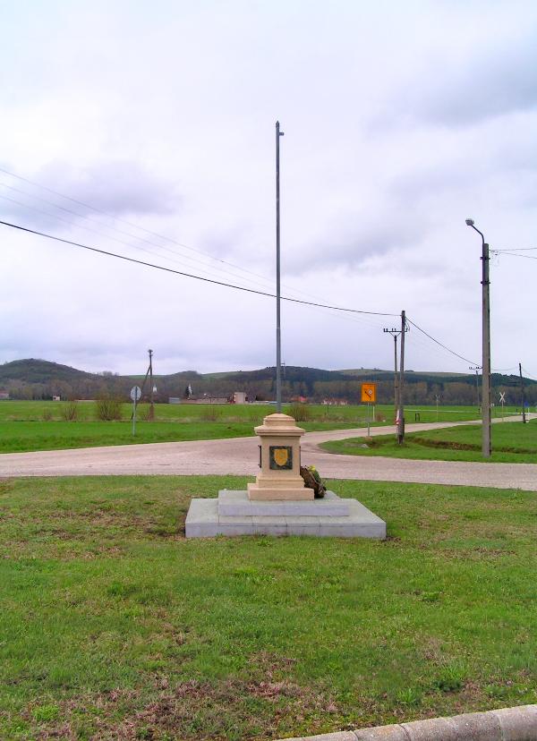
Na rozhraní oboch štátov je nedaleko dnes už
nefunkcného motorestu postavený stožiar pre vlajku
Európskej únie, pri príležitosti vstupu oboch krajín do EÚ. Po
stranách podstavca sú umiestnené štátne znaky Madarska a
Slovenska a text v oboch jazykoch.
"Táto pamätná tabula bola osadená obyvatelmi pohranicných obcí
Turne a okolia pri príležitosti vstupu Slovenskej republiky a
Madarskej republiky do Európskej únie. Hídvégardó 1.mája
2004"
ENGLISH
Not far from the cache was three border crossing points. One
Railway-crossing point (Hostovce - Tornanádaska) and two road
crossings points serving to the local border traffic (Hostovce
- Tornanadaska and Hostovce - Hídvégardó).
The building, which was built in the period of the first
Czechoslovak Republic, near the border, is on the slovak side of
the border.
At the end of the 19th century was built railway, linking Moldava
nad Bodvou with the second largest city of Hungary - Miskolc. Track
nr.325 was in traffic till end of the WWII. Currently, there is no
chances to make the rail link at this point, due to bad condition
of the whole railway.
Between the two countries is now built flag pole. On the
sides of the base are located national emblems of Hungary and
Slovakia, and text in both languages.
použité zdroje :
www.maps.google.com
www.rail.sk
www.vlaky.net