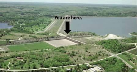
This earthcache will place you between Tuttle Creek Dam and the
Spillway System. You will need to cross the earthworks dam coming
from the west or the Spillway System coming from the east. There
has been construction to reinforce the dam for several years and
the information sign you are looking for has been inaccessible
during that time. It is along Highway 13 so watch for traffic.
The Spillway Fault System at Tuttle Creek Dam is a geological
feature that can be seen in the east side of the spillway cut. Rock
layers are offset along diagonal lines that can be traced along the
face of the cut. Signs in the northwest spillway parking lot
identify the faults visible on the opposite wall. These faults were
discovered during investigations prior to construction of the dam.
The faults actually extend across the lake and have been traced in
the hills on the west side of the lake.
These features have also been traced for several miles to the
east of the spillway. The faults do not extend below any part of
the dam or spillway gates. No earthquakes in historic times have
been associated with these faults. Microseismic studies have been
conducted by the Kansas Geological Survey with funding from the
U.S. Army Corps of Engineers. These studies used very sensitive
instruments to detect earthquakes that cannot be felt and did not
show any recent activity related to this fault system. Additional
investigations also show that there are no disturbances in the
surface soils above the fault that indicate any recent
activity.
These faults are not considered active, and do not pose a danger
to Tuttle Creek Dam.

OK now some educational stuff about faults.
Geologists can categorize faults into three groups based on the
sense of slip:
1. a fault where the relative movement (or slip) on the fault plane
is approximately vertical is known as a dip-slip fault
2. where the slip is approximately horizontal, the fault is known
as a transcurrent or strike-slip fault
3. an oblique-slip fault has non-zero components of both strike and
dip slip.
For all naming distinctions, it is the orientation of the net
dip and sense of slip of the fault which must be considered, not
the present-day orientation, which may have been altered by local
or regional folding or tilting.
Dip-slip faults
Dip-slip faults can be sub-classified into the types "reverse"
and "normal". A normal fault occurs when the crust is extended.
Alternatively such a fault can be called an extensional fault. The
hanging wall moves downward, relative to the footwall. A downthrown
block between two normal faults dipping towards each other is
called a graben. An upthrown block between two normal faults
dipping away from each other is called a horst. Low-angle normal
faults with regional tectonic significance may be designated
detachment faults.
A reverse fault is the opposite of a normal fault — the
hanging wall moves up relative to the footwall. Reverse faults
indicate shortening of the crust. The dip of a reverse fault is
relatively steep, greater than 45°.
A thrust fault has the same sense of motion as a reverse fault, but
with the dip of the fault plane at less than 45°. Thrust faults
typically form ramps, flats and fault-bend (hanging wall and foot
wall) folds. Thrust faults form nappes and klippen in the large
thrust belts.
The fault plane is the plane that represents the fracture surface
of a fault. Flat segments of thrust fault planes are known as
flats, and inclined sections of the thrust are known as ramps.
Typically, thrust faults move within formations by forming flats,
and climb up section with ramps.
Fault-bend folds are formed by movement of the hanging wall over a
non-planar fault surface and are found associated with both
extensional and thrust faults.
Faults may be reactivated at a later time with the movement in the
opposite direction to the original movement (fault inversion). A
normal fault may therefore become a reverse fault and vice
versa.
Strike-slip faults
The fault surface is usually near vertical and the footwall
moves either left or right or laterally with very little vertical
motion. Strike-slip faults with left-lateral motion are also known
as sinistral faults. Those with right-lateral motion are also known
as dextral faults.
A special class of strike-slip faults is the transform fault, where
such faults form a plate boundary. These are found related to
offsets in spreading centers, such as mid-ocean ridges, and less
commonly within continental lithosphere, such as the Alpine Fault,
New Zealand. Transform faults are also referred to as conservative
plate boundaries, as lithosphere is neither created nor
destroyed.
Oblique-slip faults
A fault which has a component of dip-slip and a component of
strike-slip is termed an oblique-slip fault. Nearly all faults will
have some component of both dip-slip and strike-slip, so defining a
fault as oblique requires both dip and strike components to be
measurable and significant. Some oblique faults occur within
transtensional and transpressional regimes, others occur where the
direction of extension or shortening changes during the deformation
but the earlier formed faults remain active.
The hade angle is defined as the complement of the dip angle; it is
the angle between the fault plane and a vertical plane that strikes
parallel to the fault.
Listric fault
A listric fault is a type of normal fault in which fault plane
is curved. The dip of the fault plane becomes shallower with
depth.
Ring fault
Ring faults are faults that occur within collapsed volcanic
calderas. Ring faults may be filled by ring dikes.
Now for the logging requirements:
Email me with the answers to these questions.
1. Tell me what type of fault you think the Spillway Fault
System is.
2. From the information board: Tell me what scale is used in the
map in the upper right corner of the information board.
3. From the coordnates you can see the spillway to the east. Look
at the end closest to you and find the numbers on the spillway.
Tell me the top most number and the largest number you can
see.
4. You can also post a picture of yourself at the location.
Thanks and I hope you enjoy my Earthcache!
Congratulations to JJTally on the FTF.