The State of Jefferson is a proposed U.S. state that would span the
contiguous and mostly rural area of Southern Oregon and Northern
California, where several attempts to secede from Oregon and
California have taken place in order to gain statehood.
This region on the Pacific Coast is the most famous of several
that have sought to adopt the name of Thomas Jefferson, the third
President of the United States. Thomas Jefferson sent the Lewis and
Clark expedition into the Pacific Northwest in 1803, and envisioned
the establishment of an independent nation in the western portion
of North America which he dubbed the "Republic of the Pacific",
hence the association of his name with regional autonomy. The
independence movement (rather than statehood) is instead known as
"Cascadia".
The name "State of Jefferson" has also been used for other
proposed states: the name was proposed in the 19th century for
Jefferson Territory (roughly modern Colorado), as well as in 1915
in a bill in the Texas legislature for a proposed state that would
be created from the Texas Panhandle region
In October 1941, the mayor of Port Orford, Oregon, Gilbert
Gable, announced that the Oregon counties of Curry, Josephine,
Jackson, and Klamath should join with the California counties of
Del Norte, Siskiyou, and Modoc to form a new state, later named
Jefferson.
Gable proposed creating this new state to draw attention to the
condition of the state roads along the Oregon-California border,
which at the time were oiled dirt roads that became impassable in
rain or snow, and handicapped economic development.
Gable's act found sympathy throughout the region, which
perceived the state legislatures as indifferent to their needs.
Siskiyou County especially embraced the cause: the county seat
Yreka became the provisional capital, where in November 1941,
county representatives met and selected the name Jefferson for
their state, in commemoration of Thomas Jefferson, the nation's
third president.
While inhabitants in Lassen and Shasta counties in northern
California flirted with joining the secession movement, only the
counties of Curry, Siskiyou, Trinity, and Del Norte actually
endorsed the idea.
A naming contest held by the Siskiyou Daily News in November
1941 considered the possibilities for the would be state: Orofino,
Bonanza, Discontent, Jefferson, Del Curiskiyou, and
Siscurdelmo.
On November 27, 1941, a group of young men gained national media
attention when, brandishing hunting rifles for dramatic effect,
they stopped traffic on U.S. Route 99 south of Yreka, and handed
out copies of a Proclamation of Independence, stating that the
state of Jefferson was in "patriotic rebellion against the States
of California and Oregon" and would continue to "secede every
Thursday until further notice."
The secession movement came to an abrupt end, though not before
John C. Childs of Yreka was inaugurated as the governor of the
State of Jefferson. The first blow was the death of Mayor Gable on
December 2, followed five days later by the attack on Pearl Harbor
on December 7. Secessionists focused their efforts on the war
effort, which crippled the movement. Coincidentally, the "state of
Jefferson" was one of the few places in the continental USA to be
the subject of an attack during World War II, when Japanese pilot
Nobuo Fujita dropped bombs on the Oregon Coast near Brookings on
September 9, 1942.
Jefferson is commemorated by the State of Jefferson Scenic Byway
between Yreka and O'Brien, Oregon, which runs 109 miles along State
Route 96 and U.S. Forest Service Primary Route 48.
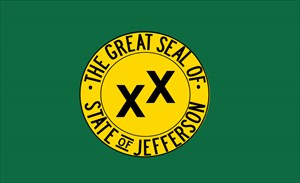
The field of the flag is green, and the charge is the Seal of
the State of Jefferson: a gold mining pan with the words "The Great
Seal Of State Of Jefferson" engraved into the lip, and two Xs askew
of each other. The two Xs are known as the "Double Cross", and
signifies the region's sense of abandonment from the state
governments in both Salem, Oregon and Sacramento,
California.