Kilsbergsförkastningen/ Kilsbergen fault EarthCache
Kilsbergsförkastningen/ Kilsbergen fault
-
Difficulty:
-

-
Terrain:
-

Size:  (not chosen)
Related Web Page
Please note Use of geocaching.com services is subject to the terms and conditions
in our disclaimer.
På Svenska / In
English

Kilsbergsförkastningen/ Kilsbergen fault
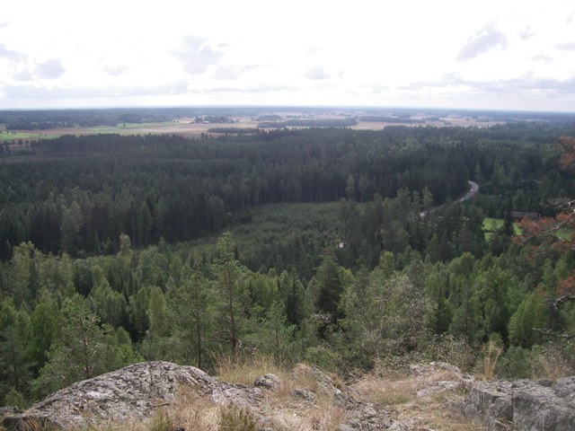
Närkeslätten/ The plain of Närke
I samband med att berg bildades i Centraleuropa för 250 miljoner
år sedan uppstod sprickor i jordskorpan. Längs dessa sprickor
försköts marken i höjdled och bildade ett naturligt
”trappsteg”. På detta sätt kom Kilsbergen att höja sig
över Närkeslätten. En spricka av detta slag kallas förkastning.
Från Närkeslätten framstår Kilsbergsförkastningen mycket
tydligt, och har gett upphov till namnet De blå bergen. I
väster finns ingen motsvarande förkastning, utan övergår omärkligt
i de värmländska skogshöjderna. Här vid Falkaberget i Rosendal
finns den kanske högsta och mest markanta förkastningsbranten längs
Kilsbergsförkastningen.
För att logga denna earthcache som hittad ska du utreda följande
punkter:
- Mät höjden på förkastningen vid givna koordinater.
- Vilken sida av förkastningen har höjt sig över
Närkeslätten?
- Vilken bäring har förkastningen?
Skicka svaren på frågorna med e-post till cacheägaren.
- Om du vill kan du bifoga en bild på dig med din gps framför
förkastningen, eller uppe på toppen med Närkeslätten i
bakgrunden.
Logga inte utan att skicka svaren. Loggar utan mailade svar
raderas. Om något är oklart kontaktar jag dig. Och skriv inte
svaren i loggen.
Använd stignätet för att ta dig till och från de olika
mätpunkterna. Tänk på att inte klättra, eller gå för nära stupet
utan säkerhetsutrustning. Fågelvägen är oftast inte bästa
vägen!
Trevlig caching!
When mountains were formed in Central Europe for 250 million
years ago, there were cracks in the crust. Along these cracks the
ground shifted in height and formed a natural "steps". In this way
came Kilsbergen to rise above the plain of Närke. A crack of this
kind is called fault.
From the plain of Närke Kilsbergen fault seems very clear, and
has given rise to the name The Blue Mountains. In the west there is
no corresponding fault, but passes unnoticed in the forest hills
and mountains of Värmland. Here at Falkaberget in Rosendal you will
find the highest and most distinguished fault in Kilsbergen.
To log this earthcache as found you should work thru following
tasks:
- Measure height of the fault at given coordinates.
- Which side of the fault has risen above the plain of
Närke?
- What bearing has the fault?
Send answer to questions by email to cache owner.
- Optional is to attach a picture of you with your gps in front
of the fault, or at the top with the plain of Närke as
background.
Do not log your visit without sending your answers to cache
owner. Logs without mailed answers will be deleted. If there is a
problem I'll contact you. Please, don't post answer to questions in
your log.
Happy caching!
Additional Hints
(No hints available.)