Located in Logan Park this is as close as I could get to Neabsco
Creek (due to another nearby cache). The purpose of this series is
to give a greater understanding of the science and history of
Neabsco Creek. This contains part of the coordinates for the final
cache located somewhere along Neabsco Creek.
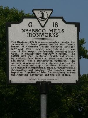
History of Neabsco Creek
Neabsco Creek was
first mapped by John Smith in 1608. The
name is a legacy of the Indian residents from the Monohoac
Tribe: the translation of Neabsco is
“at a point of rock”.
Neabsco has also been shown on some charts (1657) Niobsco.
Since the early
1700’s, Neabsco Creek has served as a waterway for trade and
commerce. Approximately one and
one-half miles upstream from this site is the location of John
Tayloe’s iron surface mine and foundry called Neabsco Iron
Furnaces. Local iron deposits, combined
with the availability of water power, provided the resources for
this industry to develop. However, the
low grade ore had to be combined with a higher grade ore for
efficient iron smelting, prompting the import of ore from Maryland
by way of the Potomac River and Neabsco Creek.
Muniitions were cast
as the foundry for the patriot armies during the Revolutionary
War. These iron works were considered
so important that in August of 1814 the English Naval War Concil
ordered the ironworks to be destroyed, but the operation
failed. The mine was closed sometime
thereafter, but was reopened in 1889 and was operated until 1920
when strikes caused its abandonment.
In addition to the
commerce on Neabsco Creek generated by the iron works, shipyards
and wharves were developed to accommodate the mineral, timber and
agrilcultural resources of this area.
Review of old charts of Neabsco Creek indicate that the Willis Saw
Mill was probably located in the wetland areas of this site.
Commencing in 1881
the U.S. Army Corps of Engineers was authorized to maintain a
channel seven feet deep and 100 feet wide from the Potomac River to
Atkinson’s Upper Landing.
Atkinson’s Upper Landing is only a few hundred feet from the
northernmost corner of the property.
River traffic, consisting of barges and lighters, proceeded
upstream of this point through the site and west to serve the iron
works and a slate mine. Barges
continued moving upstream to serve the slate mine up until the
1930’s when the U.S. Route 1 bridge was
constructed. Until then the main
highway crossed Neabsco Creek further west of U.S. 1 and was called
the Richmond-Washington Highway.
Neabsco
Creek’s character was changed significantly by the deposition
of silt due to uncontrolled runoff from tobacco farming (as has
been documented with respect to the Port of Dumfries) that followed
the extensive timbering of this area.
Poor forestry practices utilized in providing timber to local mills
such as Willis Saw Mill also contributed to this siltation
process.
The area on the
north shore of Neabsco was called “Smoketown”
(hence the name Smoketown Road) because a cloud of smoke caused by
continuous burning of brush from intensive logging operations hung
over the valley.
Historical research
suggests that in the late 1800’s this entire site was clear
cut for timber, and that the lower areas were open
water. Subsequently siltation occurred
that developed significant areas of emergent and shrub/scrub
wetlands. Possibly, this siltation also
contributed to an increase in water levels that converted adjacent
low lying areas to welands as well.
Sources:
R.
Jackson Ratcliffe, This Was Prince William (Manassas: REF
Typesetting Publishing, 1978)
Frederick Tilp, This was Potomac River (Alexandria:
Frederick Tilp, 1978)

| NOTICE:
Please be respectful of the posted park hours. If you enter the
park after hours you are trespassing. If you are stopped you can be
ticketed or arrested and will put the future of geocaching in the
parks in jeopardy. |
Congratulations to
CluelessnLuV for being FTF!!