What is a waterfall:
A waterfall is a place where flowing water rapidly drops in elevation as it flows over a steep region or a cliff. Waterfalls are considered to be one of the most beutiful phenomena in nature.
Formation of a waterfall:
Waterfalls are most commonly formed when a river is young. At these times the channel is often narrow and deep. When the river courses over resistant rock, erosion happens slowly, while downstream the erosion occurs more rapidly. As the watercourse increases its velocity at the edge of the waterfall, it plucks material from the riverbed. Whirlpools created in the turbulence as well as sand and stones carried by the watercourse increase the erosion capacity. This causes the waterfall to carve deeper into the bed and to recede upstream. Often over time, the waterfall will recede back to form a canyon or gorge downstream as it recedes upstream, and it will carve deeper into the ridge above it. The rate of retreat for a waterfall can be as high as one and half meters per year.
Often, the rock stratum just below the more resistant shelf will be of a softer type, meaning that undercutting due to splash back will occur here to form a shallow cave-like formation known as a rock shelter or plunge pool under and behind the waterfall. Eventually, the outcropping, more resistant cap rock will collapse under pressure to add blocks of rock to the base of the waterfall. These blocks of rock are then broken down into smaller boulders by attrition as they collide with each other, and they also erode the base of the waterfall by abrasion, creating a deep plunge pool or gorge.

Helmcken Falls:
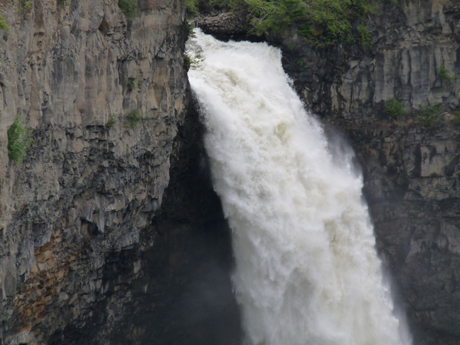
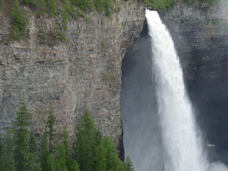
Helmcken Falls is a 141 m (463 ft) waterfall on the Murtle River within the Wells Gray Provincial Park in British Columbia, Canada. The protection of Helmcken Falls was one of the major reasons for the development of Wells Gray Provincial Park. Helmcken Falls is the 4th highest waterfall in Canada.
The falls are named for John Sebatian Helmcken, a physician with the Hudson's Bay Company who helped bring British Columbia into Canadian Confederation, but who never actually saw the falls himself.
Formation of Helmcken Falls:
As the North American continental plate drifts to the Northwest, cracks (called faults) form in the Earth's crust. The broad, level area of the Murtle Plateau was created when the land between two faults dropped hundreds of meters. Subsequent lava flows covered the plateau through which the Murtle River and Helmcken Falls have carved a route. Helmcken Falls owes its foundation to the deposits of volcanic rock in the Wells Gray-Clearwater volcanic field that were placed down in the wide valley of the Murtle River. Layer upon layer of fresh lava created flat areas, over which enormous floods flowed during the last Ice age. These floods shaped the upright cliff in the lava flows over which the river now flows. The volcanic eruptions shaped the region and gave it its remarkable morphological features. The pictures below clearly show the layers of lava that were deposited and through which the Murtle River is cutting it's course.
Other notable falls in Wells Gray Park are Spahats Falls, which almost mirrors Helmcken in it's exit over the lava flow and the very deep canyon that clearly shows the layers of lava deposited over thousands of years. Dawson Falls may be small in height but makes up for that in it's width. There are 20 or more waterfalls in Wells Gray Park.
Types of Falls:
- Block: Water descends from a relatively wide stream or river.
- Cascade: Water descends a series of rock steps.
- Cataract: A large, powerful waterfall.
- Fanny: Water spreads horizontally as it descends while remaining in contact with bedrock.
- Horsetail: Descending water maintains some contact with bedrock.
- Plunge: Water descends vertically, losing contact with the bedrock surface.
- Punchbowl: Water descends in a constricted form and then spreads out in a wider pool.
- Segmented: Distinctly separate flows of water form as it descends.
- Tiered: Water drops in a series of distinct steps or falls.
- Multi-step: A series of waterfalls one after another of roughly the same size each with its own sunken plunge pool.
1) Optional: Please post a picture of yourself or party with your GPS at the viewing platform.
In order to log this Earthcache you must do the following:
Email the owner with answers to the following questions:
a) What type of waterfall do you think Helmcken falls is?
b) Would you say there is a plunge pool behind the waterfall? Can you see anything on the rocks behind the falls.
c) Estimate the height of the canyon walls at their highest point downstream from the falls.
d) What is the name of the River into which the Murtle River flows as it leaves this canyon and enters the major canyon through the Plateau.
e) As you approach the viewing area there are 5 large information panels each with a different theme, on one of those panels it tells us what the name is of the falls that tumbles into Azure Lake. What is the name of that waterfall.
When you visit this or other Earthcaches, please take all the pictures you wish, take nothing else, and leave behind nothing to indicate you were there.
| I have earned GSA's highest level: |
 |