It originates at the Continental
Divide in the San Juan Mountains and cuts through the middle of New
Mexico to El Paso, Texas. At that point, the river begins as the
international boundary with Mexico. The river’s length from
its headwaters to the Gulf of Mexico varies as its course changes,
but in the late 1980s the International Boundary and Water
Commission stated the total length to be 1,896 miles. The official
border length is in the range of 889 to 1,248 miles.

The Rio Grande has been used as a
water source for a number of Native America tribes along its
length. Water management along the Rio Grande began as early as
1400 A.D. for the purpose of agricultural irrigation. Álvar Núñez
Cabeza de Vaca (1535 or 1536) and Francisco Vázquez de Coronado
(1540) are two of the first Europeans to experience and explore the
river. The river was not well mapped until it became the
international boundary between the United States and Mexico
following the Treaty of Guadalupe Hidalgo in 1848.
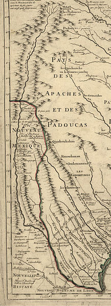
The Rio Grande (Rio del Norte) as mapped in 1718 by Guillaume
de L'Isle
Depending on how it is measured, the
Rio Grande is the twenty-second longest river in the world and the
fourth or fifth longest in North America. It drains more than
40,000 square miles in Texas alone. The river’s main
tributaries are the Pecos River, the Devil's River, the Chama
River, and Puerco Rivers in the United States, and the Rio Conchos,
Rio Salado, and Rio San Juan in Mexico. Contrary to its name, the
Rio Grande is not large enough to be navigable at all by oceangoing
ships or smaller craft. It is barely navigable at all and is
limited to canoes, rafts, and in some areas personal watercraft.
The river’s natural flow is only 1/20 the volume of the
Colorado River and less than 1/100 that of the Mississippi River.
Using a river as a natural international border is helpful since
the boundary is easily distinguished, but it has its problems too.
A meandering river such as the Rio Grande is constantly changing
position, eroding one bank and depositing on the other. Long brushy
curves, shaped like horseshoes or oxbows, frequently overflow and
form new channels. This movement complicates defining the exact
international border. Sections along the Rio Grande have been
straightened to help prevent the erosion and deposition of
sediments. One in particular is the canalization of the river
section separating El Paso from Juarez. Today, the border runs down
the middle of the deepest portion of the river.

Map of the Rio Grande Watershed
Unlike most rivers that form valleys
by cutting into the rocks, the Rio Grande River has attempted to
fill up this great depression, known as the Rio Grande Rift, with
only short periods of actual cutting into the valley-fill deposits.
The Rio Grande rises in high mountains and flows for much of its
length at high elevation; El Paso is 3,762 feet (1,147 m) above sea
level. In New Mexico, the river flows through the Rio Grande Rift
from one sediment-filled basin to another, supporting a fragile
bosque ecosystem in its floodplain. From El Paso eastward, the
river flows through desert. Only in the sub-tropical lower Rio
Grande Valley is there extensive irrigated agriculture. The river
ends in a small sandy delta at the Gulf of Mexico. Due to extended
dry weather, the river has only occasionally emptied into the Gulf
of Mexico since 2002. The river was the border, which the Republic
of Texas used between it and Mexico, but Mexico considered the
border to be the Nueces River. The disagreement provided part of
the rationale for the US invasion of Mexico in 1848, after Texas
had been admitted as a new state. Since 1848, the Rio Grande has
marked the boundary between Mexico and the United States from the
twin cities of El Paso, Texas, and Ciudad Juárez, Chihuahua, to the
Gulf of Mexico. As such, crossing the river was the escape route
used by some Texas slaves to seek freedom. Mexico had liberal
colonization policies and had abolished slavery in 1828.

Historic photo of the Rio Grande, 1899
In 1997 the US designated the Rio
Grande as one of the American Heritage Rivers. In the summer of
2001, a 328-foot (100-meter) wide sandbar formed at the mouth of
the river, marking the first time in recorded history that the Rio
Grande failed to empty into the Gulf of Mexico. The sandbar was
subsequently dredged, but it re-formed almost immediately. Spring
rains the following year flushed the re-formed sandbar out to sea,
but it returned in the summer of 2002. As of September 2006, the
river once again reaches the Gulf.
To log this Earthcache we recommend
(it is optional) that you take a picture with you and your GPS at
the listed coordinates with the Rio Grande River behind you. You
are required to email the cache owner the answer to the following
questions:
1) Given that the average Mississippi
River flow is 565,000 cu ft/s, what is the average flow of the Rio
Grande River?
2) What is the source of the Rio
Grande River?
3) What year did water management
begin along the Rio Grande?
4) Email me the exact wording on the
sign that is 240 feet south of the listed coordinates, please do
not put the answer in your post.
| I am a proud |
 |
| I have earned GSA's highest level: |
 |