Powerful Nesjavellir

|
Iceland is situated on the Mid-Atlantic Ridge, a mountain range beneath the seawater level. It separates the Eurasian Plate and North American Plate in the North Atlantic with a velocity by approx. 2 cm/year. |
Nesjavellir is situated in the near of the Hengill Volcanoe system in South-Iceland.The Hengill-Area is one of the largest high-temperature areas in Iceland.
The coordinates will lead you to a panorama platform, where you get an overview over the powerplant. You can start at the end of the road (parking place) or drive down to the parking place by the hotel. Be aware of getting the hiking map.
|

View over Thingvallavatn with the Hengill Volcanoe in the background
|
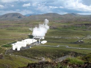
View in the valley of Nesjavellir with the smother of the Powerplant
|
Areas of geothermical activities
There are two groups of geothermical areas.
|
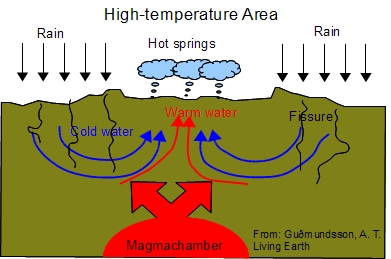
1. High-temperature Areas
High-temperature areas are only found on active volcanic belts or along their periphery. There, the water temperature is not less than 200° C at a depth of 1000 metres. Fumaroles are found there along with boiling hot springs, mud pots and geysers and a smell of hydrogen sulfide is in the air. Generally, the soil is very acidic, making it inhospitable to vegetation. Because of the high temperature, much more minerals and gases are dissolved in the water in high-temperature areas.
Precipitation is percolation through fissures in the ground. The bedrock is heated up by its proximity to the magma. The water gets in contact with the hot bedrock and is ascending and leaving the ground by generating hot springs.
The main high-temperature areas in Iceland are on the Reykjanes Peninsula, Krísuvík, Hengill (all in SW-Iceland), theTorfajökull area and Grímsvötn (S-Iceland) and Námaskarð and Krafla (N-Iceland).
|
|
|
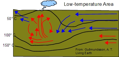
2. Low-temperature Areas
Low-temperature areas in Iceland are found all over the country, except perhaps in the East and South-east, outside the active fracture belt.
The general definition of a low-temperature area is that its temperature is less than 150° C at a depth of approximately 1000 metres. The temperature is highest in lowtemperature areas lying closest to the volcanic belt, but decreases going away from it. In low-temperature areas, geothermal heat on the surface is characterised by little or no alleration around pools and hot springs, and vegetation often reaches up to the banks. Because of the low concentration of minerals in the water in low-temperature areas, the water can be used directly for hot water supply, and it is generally deemed safe to drink.
The flowing groundwater in the higher layers of the volcanic rock is cooling down the bedrock. In deeper layers the bedrock is warming up by the heat of the earth. So the groundwater is heated up and will ascend by convection.
The largest low-temperature areas lies in southern and western Iceland, for example, the largest area Reykir is in Mosfellssveit near the capital Reykjavík and the Reykholt Area in Borgarfjördur (W-Iceland).
|
|
Using of geothermal Activity
There are two power plants in the Hengill-Area: Helliheiði Geothermal Plant in the South (via Road No. 1) and Nesjavellir Geothermal Plant in the North (via Road no. 360 from Thingvellir). Nesjavellir geothermal plant generates electricity and hot water by utilizing geothermal water and steam. The plant output is 120 MWe and 300 MWt/1800 litres per second.
Recreation
The area with its mountains and hot springs is well suited for hiking and there are a lot of hiking trails. In the near of the paring place you will find an educational path (green path on Map with descriptions of the hiking trails. Take time and join this path. It's really interesting.
Reference: Website of OR.is and the Nesjavellir Power Plant Brochure
If the road to the upper parking place is closed because of weather conditions you may answer the questions at the entrance to the power plant as well.
Have a look on the Road conditions
Questions for logging the Cache
1. Please tell me two differences between high-temperature and low-temperature areas.
2. Will you find Fumaroles exhausting hydrogen sulfide in high-temperature areas?
3. In which area you will find water with less solved minerals?
Please mail the answers to me. You don't have to wait for the log permission. If there is something wrong I will contact you. But if I don't get the answers, I will delete the log after reminding you.
Enjoy the powerful Nesjavellir.