Tory Hill:
Tory Hill is one of the great landmarks of the parish of
Mullinavat in South Kilkenny. It is readily seen from the old N9
Waterford to Dublin road but now is much more prominent as the new
M9 motorway passes quite nearby.
My little bit of research for this cache turned up three
different highwaymen/outlaws whom the hill is supposed to be called
after - James Denn, Edmund Den, and a fellow called Freyne
(don’t know his first name). There is no apparent connection
between these names and Tory, however the word Tory derives from
the Irish - Toraidhe, meaning outlaw, or more precisely, one who is
pursued. So maybe it was a refuge or hideout for these fellows at
different times.
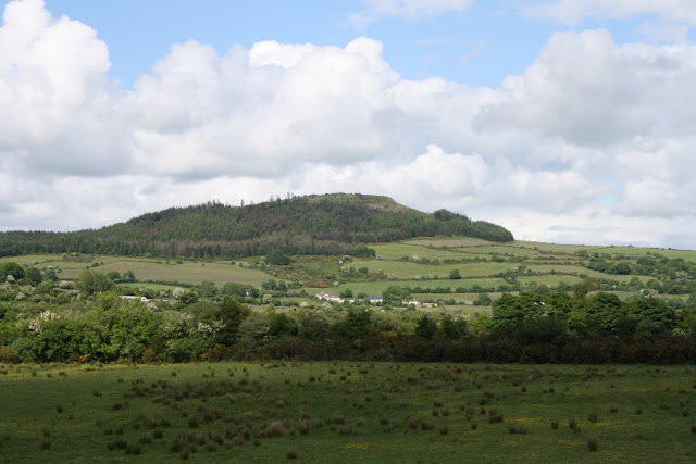
Tory Hill
Locally the hill is considered one foot short of a mountain, it
clocks in at 966 feet, so by that logic a mountain is 967 feet.
Others say it is four feet short which would leave our mountain at
970 feet. Is this the traditional height where hills end and
mountains begin? I don't know.
There is a pattern held each year on Tory Hill on the second
Sunday of July. This is locally called 'Tory Hill Sunday' and
'Frocchans Sunday'. It never was a religious celebration, but
merely consisted of the people of the neighbourhood gathering to
pick the wild berries called Frocchans (a type of bilberry). In the
Holy Year of 1950 a large cross was erected on the summit of the
hill, and since then the rosary has been said by the people who
gather beneath the cross. The cache is not far from the cross.
The cache contains a resident Nonturnal Geocoin which is not
to be removed. This is a functional nocturnal coin which you
can actually use to tell the time during the night and get your
latitudinal deviation if you want to. I have left instructions on
how to do so.
The walk to the cache is about a 4 km round trip, although a
shorter, steeper route is possible, but I recommend the longer
walk. Parking and trailhead are at N 52° 21.152’ W 007°
08.480’ There is an exit (11) off the motorway at Mullinavat
which can be used. The following wapoint is the turnoff from tarred
road to trail: N 52° 21.249' W007° 08.375'. It is safe to drive to
the trailhead on this track with an ordinary car. If the barrier is
open near the trailhead it is possible to drive to near the cross,
but I recommend a 4 x 4 for this.
The last section of the walk towards the cross passes near a
sheer drop, so be careful at night or in poor
visibility.