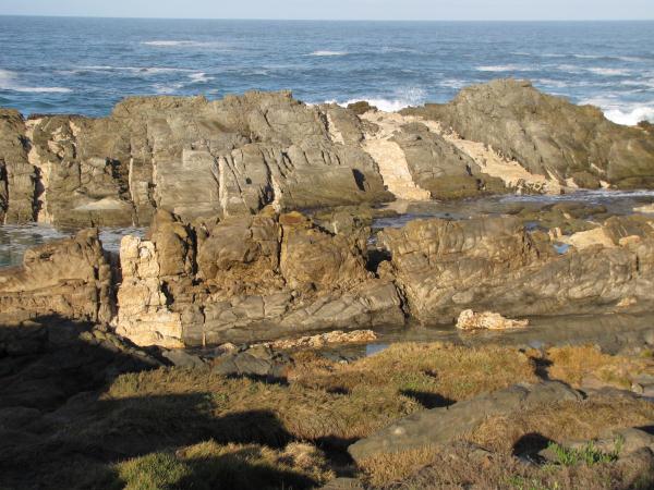
An Earth cache is a special type of Virtual Cache that is meant to be educational. Therefore to log a find you must demonstrate that you have learnt something from the site and experience.
Send your answers to us in an email via our profile page.
Any logs not accompanied by an email will be deleted.
Logging Tasks:
1) Would these quartz veins be dykes or sills?
2) How do you think these quartz veins were formed?
3) Estimate the width of the smallest and the largest vein that can be seen at this point.
4) At the listed coordinates what indigenous plants can be seen growing between the Oceanettes and the Caravan sites?
5) As an optional request please take a photo of you and your GPS with this rock formation in the background and post it with your log.
We have been to the Tsitsikamma Coast too many times to count and have always been fascinated by this coastline. We have been Geocachers for just over three years (at the time of setting this earth cache up) and have become interested in geology since doing our very first Earthcache in November 2007. We would like to share a little of what we have been able to find regarding this fascinating rock formation found here.

GEOLOGY
This part of the coastline lies in the Table Mountain Subgroup and refers to a group of rock formations within the Cape Supergroup sequence of rocks. It is a geological unit comprising alternating sandstones and shales.
The Table Mountain Group is a thick succession of creamy white to ash grey quartz sandstone, now metamorphosed to a quartzite; in places it is crushed to breccia. Examples of Table Mountain quartzite can be seen in numerous localities in the Eastern and Southern Cape, notably in the following places: Storms River and the coastal exposures along the Tsitsikamma coast eastward to Cape St Francis, the Outeniqua Pass, Prince Alfred’s Pass, the heads at Knysna, Groot River, and the Van Stadens River.
METAMORPHIC ROCKS are formed by rocks coming under great pressure and high temperatures. These temperatures and pressures are found under mountains and volcanoes, especially when continental plates move together. These conditions change the make-up of the original minerals.
Examples of metamorphic rock:
· Marble a metamorphic rock formed from limestone.
· Slate is a metamorphic mudstone or shale.
· Quartzite is metamorphic sandstone.
QUARTZITE is a tough stone composed mostly of quartz. It may be derived from sandstone or chert by regional metamorphism.
Quartzite forms in two different ways.
· In the first way, under the high pressures and temperatures of deep burial, sandstone or chert recrystallizes resulting in a metamorphic rock. A quartzite in which all traces of the original grains and sedimentary structures are erased may also be called metaquartzite. A quartzite that preserves some sedimentary features is best described as a metasandstone or metachert.
· The second way involves sandstone at low pressures and temperatures, where circulating fluids fill the spaces between sand grains with silica cement. This kind of quartzite, also called orthoquartzite, is considered a sedimentary rock, not a metamorphic rock, because the original mineral grains are still there and bedding planes and other sedimentary structures are still evident.
The traditional way to distinguish quartzite from sandstone is that quartzite fractures across or through the grains whereas sandstone splits between them.
QUARTZ is an essential constituent of granite, felsic igneous rocks and is very common in sedimentary such as sandstone and shale and is also present in variable amounts as an accessory mineral in most carbonate rocks. It is also a common constituent of schist, gneiss, quartzite and other metamorphic rocks. Because of its resistance to weathering it is very common in stream sediments and in residual soils.
While the majority of quartz crystallizes from molten magma, much quartz also chemically precipitates from hot hydrothermal veins as gangue, sometimes with ore minerals like gold, silver and copper. Large crystals of quartz are found in magmatic pegmatites. Well-formed crystals may reach several meters in length and weigh hundreds of kilograms.
Quartz Veins
Quartz is often found in veins that cut through rocks. Although the term "vein" suggests this, the veins of quartz and other minerals are usually not thin tubes, but rather thin sheets. The veins can form under various conditions, and depending on these conditions, may or may not bear quartz crystals in them.
The simplest type of a quartz vein is the filling of an already present crack in rocks. The shattering during tectonic events, by a decrease in pressure during the uplift of a rock, or because a rock cools down and shrinks. Hot brines that percolate the rocks and originate at greater depths with higher temperatures will precipitate the minerals they carry with them in cracks at lower temperatures and pressures. This process may continue until the crack is completely filled or may stop before, leaving "pockets" in the vein that are sometimes outlined by crystals. Hot brines that enter a crack in the rock from some distant hot source like a granite pluton first cool and precipitate most of their load rather quickly. The result is milky quartz, either massive or made of interlocked milky quartz crystals. Later, when the crystal growth slows down, the crystals may get less milky or even clear. In the majority quartz veins, most of the quartz is precipitated as massive, milky quartz, and well-formed crystals, if found at all, are only a small portion of the vein filling.
ACKNOWLEDGEMENTS AND RECOGNITIONS
Field guide to the Eastern and Southern Cape coasts By Roy Lubke, Irene De Moor, I. De Moor
Wikipedia