Cache is a micro log only so please bring a pen.
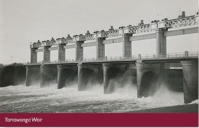
Yarrawonga Weir is located on the Murray River near the towns of Yarrawonga in Victoria and Mulwala in NSW. The Weir is approximately 230 km downstream of Lake Hume and 1,992 km from the Murray mouth.
History
Construction of the weir and its offtakes began early in 1935 and was completed in 1939. The water impounded by the Yarrawonga Weir forms Lake Mulwala, which has a capacity of 117,500 ML.
A hydro-electric generation facility at Yarrawonga Weir was commissioned in June 1994. The facility has a maximum capacity of about 9.6 MW.
Operations
Yarrawonga Weir raises the water level of the River Murray to allow diversions of water under gravity. An average of 1,900 GL or 17% of the river's annual flow is diverted annually to the Yarrawonga Main Channel and the Mulwala Canal.
The Yarrawonga Main Channel services the Murray Valley Irrigation Area of Victoria, which extends from Yarrawonga to Barmah and south to the Broken and Nine Mile Creek systems. The channel has a discharge capacity of 3,100 ML/d and distributes water to an area of 128,000 ha via a network of six main channels and 261 spur channels.
There are co-ordinates for a recommended parking area which has a nearby pedestrian path taking you past a portion of the Golf Club and then onto the bridge. However you may choose to park on the Victorian side and walk the length of the Weir Wall which takes in the views of the South Gates also.
Please be aware that this weir is opened to one way traffic which is directed by the traffic lights in place.
