Deutsche Version:
Die Landschaft am Rande des Gießener Beckens wird geprägt von zahlreichen markanten Basaltkuppen. Sie sind Ausläufer des Vogelsbergs, Europas größtem zusammenhängenden Basaltmassiv, das entstand, als im Tertiär vor rund 19 Mio. Jahren die Kontinentalplatten von Europa und Afrika zusammenstießen. Ein feuerspeiender Vulkan war der Vogelsberg aber ebenso wenig wie seine kleineren Kollegen, egal ob sie Gleiberg, Vetzberg, Hangelstein oder Totenberg heißen - oder eben "Lollarer Kopf". Auch wenn ihre gleichmäßige Kegelform es vermuten lässt: einen Krater findet man bei fast keinem der Köppel.

Der Grund, warum der Lollarer Kopf so exponiert über dem Lumdatal thront, liegt in der Festigkeit des magmatischen Gesteins, das auf seinem Weg nach oben erhärtete, noch bevor es die Erdoberfläche durchbrechen konnte. Diese sogenannten Schlote wurden dann in den folgenden Jahrtausenden langsam freigelegt: Das umgebende Sedimentgestein - Buntsandstein und tertiäre Ablagerungen - war dem subtropischen Klima der damaligen Zeit auf Dauer nicht gewachsen und wurde abgetragen. Übrig blieb der Basaltstiel - abgeschliffen und zerbröselnd, aber immer noch mächtig.
Besteigt man den Lollarer Kopf, so entdeckt man im Buchenwald immer wieder einzelne spitz aufragende Basaltstöcke, die wie Salzkristalle in zahllose fünf- oder sechskantige Säulen zergliedert sind. Diese Wabenstruktur ist Folge des langsamen Abkühlungsprozesses beim Aufstieg durch den Schlot.
Wegen seiner Härte und Haltbarkeit wurde Basalt schon zu Beginn des 20. Jahrhunderts industriell abgebaut, in Steinbrechmaschinen zu Schotter zerkleinert und als Unterbau für Straßen verwendet. Eine solche dampfgetriebene Brechanlage stand seit 1905 auch in Lollar - nördlich der Holzmühle ganz in der Nähe zur Lumdatalbahn. Von hier konnte der Schotter mit Güterzügen rasch abtransportiert werden.
Ende der 80er Jahre wurde der Abbau schließlich eingestellt und der Steinbruch rekultiviert. Er ist heute ein Refugium für zahlreiche seltene Tier- und Pflanzenarten, die von den ungewöhnlichen Standortbedingungen profitieren. Denn nackter Fels findet sich in unseren Breiten von Natur aus nur sehr selten.

Zum loggen des Caches lade bitte ein Bild, das Dich oder Dein GPS vor dem Basaltstock an den Cachekoordinaten (siehe oberes Foto) zeigt zusammen mit dem Log hoch und beantworte die folgenden Fragen per E-Mail an meine Adresse:
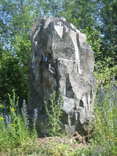
- Wie hoch ist der Basaltstock (siehe unteres Foto) am Steinbruch (siehe Waypoint)?
- Wie kam der Basalt vom 1 km entfernt liegenden Steinbruch zur sogenannten Klopfsteinmühle? (siehe Infotafel)
Es darf direkt geloggt werden, bei Problemen melde ich mich. Logs ohne Antworten sind ungültig.
English version:
The landscape on the border of the Giessener Becken is characterized by numerous salient basalt buttes. They are foothills of the Vogelsberg, Europe's largest continuous basalt massif which was formed when in Tertiary 19 million years before the tectonic plates of Europe and Africa collided. Vogelsberg was not a volcano that spit fire, just as few of its smaller counterparts Gleiberg, Vetzberg, Hangelstein or Totenberg - or just "Lollarer Kopf". Although suspect their uniform conical shape: a crater was found in almost any of the hills.
The reason why the Lollarer Kopf sits so exposed on the Lumdatal, is caused in the strength of the magmatic rocks that hardened on his way up before breaking the surface. These so-called chimneys were then slowly cleared in the following centuries: the surrounding sedimentary rocks - sandstone and tertiary deposits - wasn't equal to the subtropical climate of that time and so it was removed. It remains a basalt stick - polished and crumbling, but still powerful.
Ascending the Lollarer Kopf, we discover towering basalt sticks in the beech forest, like salt crystals dissected in countless penta- or hexagonal columns. This honeycomb structure is the result of the slow cooling process during the ascent through the chimney.
Because of its hardness and durability basalt was already industrially redused at the beginning of the 20th century, crushed into gravel and rock crushing machines used as a base for roads. Such steam-powered crushing machine was located in Lollar since 1905 - north of the Holzmühle near the Lumdatalbahn. From here the gravel could be removed quickly with freight trains.
End of the 1980´s the reduction was finally stopped and the quarry was re-cultivated. Now it is a haven for many rare animal and plant species which benefit from the unusual site conditions. Bare rock is in our region by nature very rare.
To log this cache please upload a photo showing you or your GPS in front of the basalt stick at cache coordinates (see first photo) together with your log. Further you have to answer the following questions by using my e-mail address:
- What is the height of the basalt stick (see second photo) at the quarry (waypoint)?
- How came the basalt from the quarry on a distance of 1 km to the so-called Klopfsteinmühle? (see info panel)
You may log directly, I’ll contact you in case of problems.
Logs without answered questions are not valid.