Regulacia rieky
papradnianky
SK listing (English listing below):
V 1. polovici 20. storocia sa v udoli rieky Papradnianka
castokrat opakovali zaplavy a vznikali rozsiahle skody. Koryto
rieky bolo plytke a brehy spevnene len stromami a krikmi.
Najnicivejsia povoden, na ktoru si este niektori obyvatelia
Papradna pamataju, bola v roku 1929. Voda sa vyliala z koryta a
zaplavila velku cast dediny. Po povodni sa v tejto casti dediny nad
cestou vybudoval kamenny oporny mur (takzvanu Papradniansku
stavnicu), ktory tam stoji dodnes.
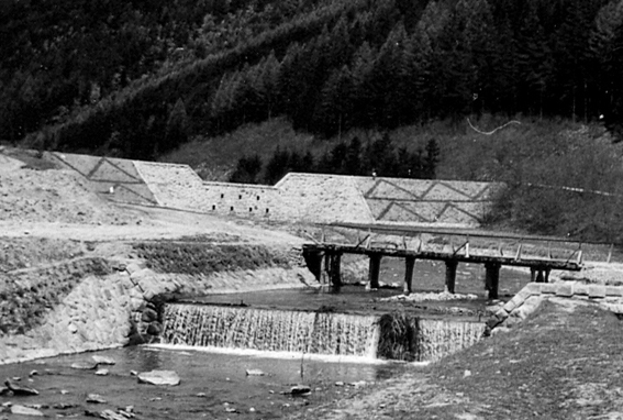
S vystavbou tejto vysokej kamennej prepazky sa zacalo v roku
1943 v casti Kosiare. Zasluhu na tom ma Ing. Jan Chrapko, rodak z
Papradna, ktory v tom case posobil v Bratislave ako ministersky
radca. V jeho kancelarii sa vypracoval projekt a pricinil sa aj o
jeho realizaciu. Podstatna cast materialov na vystavbu, ako kamen a
piesok, pochadzala z miestnych zdrojov. Blizko buducej priehrady sa
otvoril kamenolom, z ktoreho sa potom tazil kamen na regulaciu
celeho poriecia Papradnianky.
Este pred zaciatkom vystavby priehrady sa musela prelozit
cesta, ktora v tom case viedla korytom rieky. Z vykopovych prac sa
hlina navazala na teleso novej cesty. Priehrada bola ukoncena v
roku 1946. Najprv sa postavila len kamenna hradza, ale ked sa
zistilo, ze podla priehradoveho muru presakuje voda, museli sa
dodatocne v roku 1948 nasypat bocne kridla.
Od priehrady sa vyregulovalo len kusok rieky. Kamenna uprava
brehov rieky cez obec, s dvanastimi kaskadami cez Papradno sa
ukoncila v roku 1956. Vsetky vykopove prace, aj na stavniciach,
ukladanie kamena a nasypavanie brehov sa robili rucne, s drevenymi
furikmi. Kamen z lomu sa dovazal na konoch, neskorsie na
traktoroch.
Po skonceni regulacie sa na stavnici j styridsat rokov
nerobila ziadna udrzba az do roku 1986, ked cez priehradovy mur
zacala presakovat voda sa muselo prikrocit k rekonstrukcii, pocas
ktorej sa na spevnenie muru pouzilo 285 m3 zelezobetónu. Odvtedy sa
priehrada iba pravidelne cisti od nanosov bahna a strku.
Ku keske: Samozrejme ju nehladajte na horeuvedenych
suradniciach. Kedze sa jedna o multinu, nachadza sa inde. Touto
keskou by som vam rad ukazal jedno unikatne stavebne dielo v
papradnianskej doline, zoznamil vas s jeho historiou a ulohou, ako
aj ukazal trosku okolitej prirody a prijemnych miest na oddych.
Stage 1: Po prichode na miesto budete vidiet vodne
vypusty v stavnici (tie diery na vypustanie vody). Zratajte pocet
otvorov v jednotlivych radoch:
pocet vypustov v hornom rade je hodnota A
pocet vypustov v strednom rade je hodnota B
pocet vypustov v dolnom rade je hodnota C
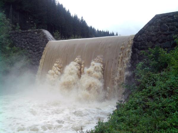
Pozor: v zimnych mesiacoch, pripadne pri zvysenej hladine rieky
(ako na obrazku hore) nemusi byt vsetky vypusty vidiet, ale verim,
ze s tymto problemom si lahko poradite aj od stolu.
Stage 2: Na vzdialenejsej strane hradzoveho muru najdete
v betone vytlacene tri letopocty vo formate xxxx-DEFG-xxxx.
Vas teda bude zaujimat len stredny letopocet. Tu odporucam
nespekulovat a nespoliehat sa na horeuvedeny text. Odvaznejsi mozu
prejst po hradnom mure na druhu stranu, menej odvazni mozu pouzit
mostik, ktory je cca o 200 m nizsie, vid waypoints.Mostik taktiez
pouzite, pokial rieka preteka vrchom hradze, vid. horny obrazok
Stage 3: K tomuto stage pouzite hlavnu cestu az po
najblizsi mostik. Po lavej strane si mozte prezriet vodny rezervoar
nad priehradnoym murom a taktiez si mozte porovnat rozdiel v
regulacii rieky nad a pod priehradnym murom. Koordinaty vas privedu
ku kanadskej borovici pri ktorej stoji kriz. Na samom spodu kriza
je vyrezany letopocet. Posledne cislo letopoctu je H. Cislo
je skutocne zle viditelne, takze budte vsimavi.
Final: Ziskane cisla dosadte do koordinatov
N 49° 14.FGH
E 018° 23.BIC
Kde I = (E:A)-A
Pre FTFkarov je pripravena tekuta miniodmena
Happy caching
Spravne riesenie si mozte skontrolovat tu:
Geochecker.com.
English listing:
The floods in the first half of 20th century in the valley of
river Papradnianka were a common thing, causing massive damage to
the people and the land. The most destructive flood happened in
1929. Most of the village Papradno was under water. As a
consequence, the representatives of the village decided to build a
stone dam that should prevent this situation to happen
again.
The construction of this stone barrier started in 1943 in the
village region Kosiare. The biggest credit for starting this
project goes to Ing. Jan Chrapko, born in Papradno, that at that
point in time has been working as an advisor to the minister in
Bratislava. The major part of the building material for the barrier
has been taken from a local stone quarry that has been opened close
to the building site.
Prior to the start of the construction of the barrier, the
road to Podjavornik had to be shifted right, because the original
road would be under water. The loam removed from the river basin
was used as an underlayer for the new road. The construction wok
had been finished in 1946. In 1948 the barrier was enhanced both
ways due to the water leakage.
Only a smal fraction of river basin has been regulated at
that point of time. The full regulation of the river flow has,
including 12 cascades, has been finished in 1956. All the
construction work, including laying of the stones and removal of
the loam has been performed manually. The stone from the stone
quarry has been transported, using horses and tractors.
No major maintenance has been done on the river dam until
1984, when the barrier started to leak water again. For the
reconstruction of the dam has been used 285 m3 of reinforced
concrete. Since then, the dam is only being cleaned regularly from
the mud and gravel sediments.
To cache: Cache is not to be found on the above mentioned
coordinates. You can find it after solving the following tasks. By
this cache I would like to show you one unique built structure in
the valley of Papradno, introduce you to its history and purpose,
as well as to show you the local nature and pleasant places for
picnic.
Stage 1: When you hit the stage 1 coordinates, you will
clearly see the water vent holes. Count the vent holes in each row,
where:
A would be the number of vent holes in the upper row
B would be the number of vent holes in the middle row
C would be the number of vent holes in the bottom row
Be aware: during the winter, or when the water level is too high
you cannot see all the vent holes. However, I am sure you can sort
out this problem even from home.
Stage 2: On the farther side of the dam you can find
three dates carved into the stone in the form
xxxx-DEFG-xxxx. Obviously, only the middle date is
important. Cachers with enough courage could cross the river
crossing the dam. Others could use the bridge that is 200 m below,
see waypoints.Please, use the bridge also in the case that the
water is pouring over the top of the dam
Stage 3: To reach this stage, please use the main road
unil you come to the nearest bridge. Walking there, you can see the
water reservoir formed by the dam. The coordinates will take you to
a canadian pine and a crucifix. On the very bottom of the crucifix
is a carved date. The last digit of the date is the value H.
The date is hard to see, so please be thorough.
Final: The number you have been supposed to get from the
stages input into the coordinates
N 49° 14.FGH
E 018° 23.BIC
Where I = (E:A)-A
Happy caching
You can check your answers for this puzzle on
Geochecker.com.