The "Mystery Bridge" Adventure Multi-Cache
cache4pat: It's time to Archive this great cache .... too many recent DNFs and this past year's flood levels has made maintaining it too difficult.
The "Mystery Bridge" Adventure
Please note Use of geocaching.com services is subject to the terms and conditions
in our disclaimer.
Just came across this great place and surprisingly no cache present here yet? Well .. here it comes...
First of all, a questions come to mind .. what bridge was this? What was its name? When was it built and for what purpose? When it stopped being used and when it crumbled down?
If you look in google map, you can see reminders or road or tracks through fields to the east of the river, but none to the west??
It is a MYSTERY....
I will give some description of the cache now .. Solution to the mystery follows after that...
*******************************************
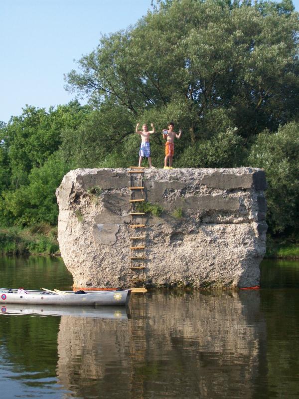
You are up to a Multi stage River cache. All stages are within walking, wading, or paddling distance. We used canoe to get kids and gear closer, but it is not really necessary.
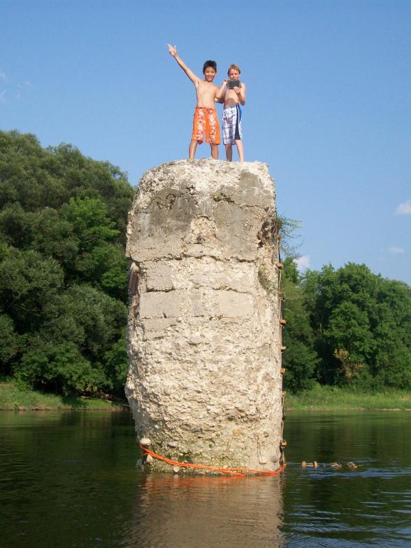
FIRST STAGE is on old pylon of the bridge. You are searching for stainless steel plate 3 x 5 inches. You are likely to need a rope or ladder (or rope ladder  ). Picture is attached for more insight.
Please ensure the Stage1 plate remains near the CENTER of the River Pylon
Stage 1 re-directs you to the FINAL, which is a 35 mm film canister with a log book. Sorry, no pen fit in.
Some climbing skills will be required here again. Be mindful of the bottom; water shoes recommended.
Have fun!
*******************************************
Now, back to the MYSTERY BRIDGE:
From rych mills, local historian
The short answer is that there is no name to the never-built bridge where the abutments are on the Grand River near Bridgeport.
The long answer is:
Peoples Railway was one of many private enterprises that sprang up in the wake of the development of Niagara Falls hydroelectric power. Adam Beck himself envisioned a web of electric railways (radials) covering the province and taking people hither and yon at a really cheap rate. The one which concerned Berlin [now Kitchener] most was the Peoples Railway. There were others which would have sent a branch line into Waterloo County [now Region of Waterloo] but none got as far as the Peoples Railway.
The Bugg Brothers from Stratford provided initial financing and being good salesmen were able to persuade several communities along their proposed route to get by-laws passed which would provide capital and operating expenses via bond issues.
The route was anchored on two legs in the west at Stratford and Woodstock with those two lines joining at New Hamburg. Baden, Petersburg, Berlin, Bloomingdale, New Germany [now Maryhill] and Guelph were on the main route, with branch lines feeding from Wellesley, New Dundee, Ayr and Breslau. Their map, slightly adjusted, shows the line straight from Berlin to Bloomingdale to New Germany to Guelph, with Breslau being well south... we know, that isn’t quite so!
For about three years between 1908 and 1911, the Peoples Railway worked feverishly: 1) marketing the project and getting communities involved financially and enthusiastically; 2) arranging with property owners along the route for rights of way; 3) having the route surveyed and staked; 4) planning sites for stations; 5) building embankments where needed to make the future track bed level and building bridges over small creeks and gullies. Most of this work got done west of Berlin only; 6) building the big bridge over the Grand River downstream from Bridgeport and across farmers’ fields (the Kraft farm for example, where some embankments are still visible across the fields) to reach Bloomingdale.
Around 1910 financial problems started. The Bugg’s money wasn’t unlimited. A lot of the bonus by-laws passed provided no money until certain work was done and some even required trains to be running. Debt grew. Workers weren’t getting paid. By the time the Buggs pulled out, and the plans fell flat, not a single railway tie had been laid and not a rail had been placed. What did get built and what remains were five or six large concrete abutments across the Grand River. One has fallen into the river, one stands proud – having resisted ice floes for a hundred years !! – and several more are in the bush on the east side of the Grand, hidden for the most part by leaves. Apart from the odd glimpse of earthwork embankments between Bloomingdale and the Grand River, this is all that remains of the scheme.
Where the abutments are, there can also be seen the foundation walls of the sugar beet factory’s water pumping station. But that’s another local history story.
Thanks so much to rych mills for research done and great write-up.
Thanks also EFD118 and mlroes for directing me to the right person.
Additional Hints
(Decrypt)
Fgntr1: 20 sg nobir jngre, Svany: Nyfb 20 sg+ HC.
Treasures
You'll collect a digital Treasure from one of these collections when you find and log this geocache:

Loading Treasures