Boat Rock Traditional Cache
-
Difficulty:
-

-
Terrain:
-
Size:  (small)
Please note Use of geocaching.com services is subject to the terms and conditions
in our disclaimer.
Please note the following WayPoints in reaching this area:
Gate: S 35 47.787 E 145 58.181
PLEASE ENSURE THAT GATES ARE CLOSED BEHIND YOU WILL PASS THROUGH PRIVATE PROPERTY VIA PUBLIC ACCESS TRACK TO REACH THIS LOCATION. ROAD TO GZ IS DIRT.
Boat Rock: S 35 47.913 E 145 58.126
Cache is a 400ml sistema container.
Aboriginal Diggings - Boat Rock
The Pangerang Tribe were the original aboriginal inhabitants of
this area from Howlong to Berrigan who are attributed with naming
the two nearby towns. "Yarra" means "water running over rocks" and
"wonga" was named after the "wonga pigeon". Mulwala means "big
lagoon" or "big back water".
In 1841 there was believed to be 12,000 members of the Pangerang
tribe along the Murray River. White settlement however changed this
very quickly.
By 1870 the last corroboree was enacted by warriors in full war
paint. On October 10th, 1888 an aboriginal woman by the name of
Mary Jane Milawa died. She was believed to be the last member of
the Pangerang tribe.
The Australian Aboriginals have never been considered people who
prepare for the future. The Boat Rock is a man made reservoir to
catch and hold water for use over the summer period.
Considerable initiative was shown in its creation. A large fire was lit on the site then allowed to cool. When cold, gravel would be loosened and dug out. This process was repeated until a hole 2 metres deep was made. It would have taken countless repetitions to have reached that depth.
The site for the hole was chosen with great care and foresight. A small shower of rain is sufficient to fill the hole with water, which is necessary over the summer period.
Within close vicinity to the Boat Rock are Kangaroos which stay in the area because of the water supply. This made them an easy catch for the aboriginals. This water hole is situated on the only hill for miles / kilometres around.
The Boat Rock is on land proclaimed by the Government, it is not a picnic area. To get to it you have to pass through private land. Please remember to close both gates as you pass through.
Even though there are no facilities there, Boat Rock is one of a kind and thus you will not see a phenomenon like this anywhere else in the world. 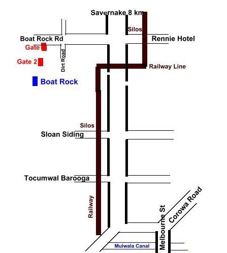
For those who are interested, there is also a GCA Trig Point at this location - refer TP3328 - which you may wish to log whilst here.

Additional Hints
(No hints available.)
Treasures
You'll collect a digital Treasure from one of these collections when you find and log this geocache:

Loading Treasures