|
Corgo das Mós [Serra da Estrela]
Panorâmica 360º Panoramic
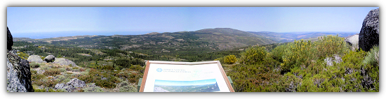
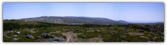
[PT] O Corgo
das Mós é um miradouro natural na zona das Penhas Douradas,
conhecido também por ser nas imediações que nasce o maior rio
Português. Para norte as vistas recaem sobre um imenso planalto, o
planalto de Videmonte e Casais de Folgosinho, de formação xistosa,
por onde corre o Rio Mondego no seu percurso de montanha, que 227
km depois desagua na Figueira da Foz. A Nascente, encavalitada nas
serranias, a cidade da Guarda. Para Sul a Torre lá no alto com as
suas bolas faz a divisão entre a terra e o céu. Para Oeste e lá bem
ao fundo a Serra do Caramulo, e entre as duas (Caramulo e Estrela)
a Cidade de Viseu.
[EN]
The “Corgo das
Mós” is a natural viewpoint in the area of “Penhas
Douradas”, also known because, nearby, it born the longest
Portuguese river. To the north the views are passed on a huge
plateau, the plateau of “Videmonte” and “Casais
de Folgosinho”, of schistose formation, through which flows
the “Mondego” river, in their mountain path, flowing
227 km later in “Figueira da Foz”. To east ensconced in
the mountains, the town of “Guarda”. To the south the
“Torre” with their balls, separates the earth from the
sky. To west in background the, “Caramulo” sierra, and
between the two (“Caramulo” and “Estrela”)
the city of Viseu.
|
Para cá chegar existem, de entre outras,
duas opções:
A – Tomar o estradão no Waypoint
M1 e seguir até ao Waypoint M3.
Distância: 1Km (2Km ida e
volta)
Meios: TT, BTT e a Pé
(recomendado).
B – Tomar o estradão no Waypoint
M2 e seguir até ao Waypoint M3.
Distância:1,2Km (2,4Km ida e
volta)
Meios: TT(Trial), BTT e a Pé
(recomendado). A meio caminho existe um troço em muito mau
estado com rodeiras de cerca de 50cm de
profundidade.
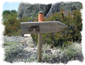
Chegados ao Waypoint M3 onde existe uma seta de
madeira, deixem o estradão (só aqui) e sigam as mariolas na
direcção indicada pela seta (de madeira e do GPS). Desfrutem da
calma do local.
|
To get here, you have two options from
among others:
A – Take the dirt road at waypoint
M1 and follow to Waypoint M3.
Distance: 1Km (2Km round
trip)
Transportation: TT, BTT and by foot
(recommended)
B – Take the dirt road at waypoint
M2 and follow to waypoint M3.
Distance: 1,2Km (2,4Km round
trip)
Transportation: TT(Trial), BTT and by
foot (recommended). Halfway there is a section in very poor
condition with rutting of about 50cm deep.
Once at Waypoint M3 where is a wood arrow,
leave the dirt road (only here) and follow those small stone piles,
at the arrow direction (Wood and GPS). Enjoy the nice and quiet
place.
|
Conteúdo inicial: Berlindes, flor, tazo, fita laranja (porta
telemóveis), helicóptero manual azul (desmontado)
|