Aeolian islands - Panarea EarthCache
Aeolian islands - Panarea
-
Difficulty:
-

-
Terrain:
-

Size:  (not chosen)
Please note Use of geocaching.com services is subject to the terms and conditions
in our disclaimer.
English version:
Panarea is the second smallest (after Basiluzzo) of the eight
Aeolian Islands, a volcanic island chain north of Sicily. Panarea
itself has a total surface area of about 3.3 km2 and rises to a
maximum elevation of 421 m at Punta del Corvo.

Geological evolution The island has one of the most important
archaeological sites in the Aeolian archipelago and hikers will be
surprised to find a well-maintained network of trails leading to
all points of naturalistic interest, which also offer stunning
panoramic views. Panarea is of charming beauty and deserves a visit
by anyone interested in nature, history, and geology.
The small size of Panarea belies a fairly complex volcanic history,
which started about 200 ka (200,000 years) ago, and which is
characterized mainly by the extrusion of viscous, (partially
high-potassium) calc-alkaline magmas (basaltic andesites to
dacites) to form domes and minor "coulée"-like flows. The volcanic
products constituting the island are subdivided into three stages:
Palaeo-Panarea Stage, Intermediate Stage, and Final Stage; these
are followed by the most recent volcanics emitted from the eruptive
centers lying 2-4 km to the east and northeast (Dattilo, Lisca
Bianca, Lisca Nera, Bottaro, Panraelli, and Basiluzzo).
The Palaeo-Panarea products occur in the northern part of the
island, forming mainly domes and minor flows of andesitic-dacitic
composition (Calcara, Punta Palisi, Scoglio la Nave, Punta
Scritta). The dome-coulée of Ditella, lying in the northeast part
of Panarea, and some lavas covered by pyroclastic breccias
outcropping in the steep western face of the island might also
belong to this stage. In the south part of the present island,
explosive activity and emission of andesitic lavas was followed by
the extrusion of two steep-sided dacitic lava domes or spines, the
Punta del Tribunale and Castello, which are among the most peculiar
morphological features of Panarea.

Extrusion of lava domes also characterized the eruptive activity of
the Intermediate Stage, many of them forming a NW-SE oriented ridge
that extends from Castello di Salvamento (northwest part of the
island) to Punta Falcone, a steep-sided dome overlooking the
village of Panarea; another row of domes extends SSW to Punta
Muzza. The latest products of this stage, of andesitic composition,
were emplaced in the northwestern and SSE parts of the island, the
latter forming the spectacular peninsula of Capo Milazzese, which
hosts the remains of a Bronze Age village. The final stage of
volcanism began after a period of repose and led to the formation
of a large lava dome at Cardosi in the northwest part of the
island, which constitutes much of the high central area including
the present summit at Punta del Corvo; several thick lava flows
extended from the base of the dome mainly to the southeast and
south. Dome growth was accompanied by explosive activity that
deposited andesitic scoriae in the Punta Falcone-Punta del Corvo
area and dacitic pumice in the Castello di Salvamento area (all
lying in the central-northern portion of Panarea). This period
ended sometime before 130 ka; no volcanism has occurred since then
on the island of Panarea. This so-called final stage, however, did
not mark the end of all things for Panarea's volcanism. Instead,
the focus of volcanic activity shifted away from the main island
out into the sea to the east, where about 130 ka ago, the dacites
forming the Panarelli were erupted. Less than 10,000 years ago, a
large lava dome rose out of the sea further to the north, to form
what is now Basiluzzo island. This latest eruptive episode was
followed by collapse and subsidence that has continued to very
recent times, as is testified by the remains of Roman buildings
that now lie beneath the sea level. This area of the latest
volcanism in the Panarea complex still shows the presence of active
fumaroles that lie at a depth of several tens of meters below the
sea level. As noted above, these fumaroles increased their output
notably in early November 2002; a new apparent increase in late
January 2004 was due to landsliding on the submarine slope of the
Lisca Bianca and not to increased gas output.
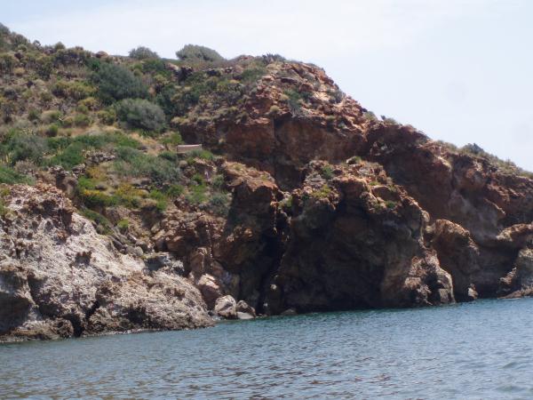
This coordinates will bring you to a one of beautiful places of
this island.
To log this Earthcache following tasks from this place should be
fulfilled:
- You can find here some very old sights - wrote me what is it
and the form of this sights?
- From which era are this sights?
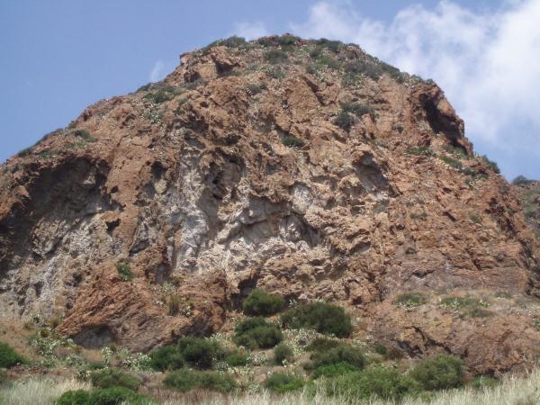
- Take a look from seaside (to the sea) and you can see two
interesting formation. Which ones?
- The name of further of them?
Optionally:
- I will be glad if you will enclose some picture to your
log

Google Italian:
Panarea è la più piccola secondo posto (dopo Basiluzzo) delle otto
isole Eolie, una catena di un'isola vulcanica a nord della Sicilia.
Panarea si ha una superficie totale di circa 3,3 km2 e sorge ad un
altitudine massima di 421 m di Punta del Corvo. evoluzione
geologica L'isola ha uno dei siti archeologici più importanti di
tutto l'arcipelago eoliano e gli escursionisti saranno sorpresi di
trovare una rete ben mantenuto di sentieri che conducono a tutti i
punti di interesse naturalistico, che offrono anche una splendida
vista panoramica. Panarea è di una bellezza affascinante e merita
una visita da parte di chiunque interessato alla natura, storia e
geologia. Le piccole dimensioni di Panarea nasconde una storia
piuttosto complesso vulcanico, che ha iniziato circa 200 ka
(200.000 anni) fa, e che si caratterizza soprattutto per
l'estrusione di viscoso, (in parte alta di potassio) magmi
calc-alcalina (andesiti basaltiche a dacites) per formare cupole e
minori "Coulée, tornate"-come flussi. I prodotti vulcanici che
costituiscono l'isola sono suddivise in tre fasi: Fase
paleo-Panarea, Intermedio Stage, e ultima fase, che sono seguiti
dal vulcaniti più recenti emessi dai centri eruttivi mentire 2-4 km
a est e nord-est (Dattilo, Lisca Bianca, Lisca Nera, Bottaro,
Panraelli e Basiluzzo). I prodotti di paleo-Panarea si presentano
nella parte settentrionale dell'isola, formando principalmente
cupole e dei flussi di minori di composizione andesitica-dacitic
(Calcara, Punta Palisi, Scoglio La Nave, Punta Scritta). Il Coulée,
tornate cupola di Ditella, situata nella parte nord-est di Panarea,
e alcune lave coperti da brecce piroclastiche affioranti di fronte
ripido occidentale dell'isola potrebbe anche appartenere a questa
fase. Nella parte sud dell'isola di specie, attività esplosiva e
l'emissione di lave andesitica è stata seguita dalla estrusione di
due cupole scoscese lava dacitic o spine, la Punta del Tribunale e
Castello, che sono fra le caratteristiche più peculiari
morfologiche di Panarea. Estrusione di cupole di lava caratterizza
anche l'attività eruttiva dello stadio intermedio, molti di loro
formando una cresta orientata NW-SE che si estende dal Castello di
Salvamento (parte nord-ovest dell'isola) a Punta Falcone, una
cupola ripida che domina il villaggio di Panarea, un'altra fila di
cupole SSW si estende fino a Punta Muzza. Gli ultimi prodotti di
questa fase, di composizione andesitica, sono state piazzate nella
parte nord-occidentale e SSE dell'isola, che costituiscono di fatto
la spettacolare penisola di Capo Milazzese, che ospita i resti di
un villaggio dell'età del bronzo. La fase finale del vulcanismo ha
iniziato dopo un periodo di riposo e ha portato alla formazione di
una cupola lavica di vasta portata a Cardosi nella parte nord-ovest
dell'isola, che costituisce gran parte della zona alta centrale,
compresa l'attuale vertice di Punta del Corvo; spessi alcuni flussi
di lava estese dalla base della cupola, soprattutto a sud-est e
sud. Dome crescita è stata accompagnata da attività esplosiva che
depositate scorie andesitica nella zona di Punta Falcone-Punta del
Corvo e pomice dacitic nella zona di Salvamento Castello (tutto
giace nella parte centro-nord di Panarea). Questo periodo si è
concluso poco prima del 130 ka, nessun vulcanismo si è verificato
da allora l'isola di Panarea. Questa fase cosiddetta finale,
tuttavia, non segna la fine di tutte le cose per il vulcanismo di
Panarea. Invece, il focus di attività vulcanica spostata dall'isola
principale verso il mare ad est, dove circa 130 ka fa, il dacites
formando la Panarelli erano esplose. Meno di 10.000 anni fa, una
cupola di lava larga rosa dal mare più a nord, per formare quella
che oggi è isola di Basiluzzo. Questo ultimo episodio eruttivo è
stata seguita da crolli e cedimenti, che ha continuato a tempi
molto recenti, come è testimoniato dai resti di edifici romani che
attualmente si trovano sotto il livello del mare. Questa zona del
vulcanismo più recente del complesso Panarea mostra ancora la
presenza di fumarole attive che si trovano ad una profondità di
alcune decine di metri sotto il livello del mare. Come osservato in
precedenza, queste fumarole aumentato la loro produzione in
particolare nei primi di novembre 2002; un nuovo aumento apparente
alla fine di gennaio 2004 è stato a causa di frane sul versante
sottomarino della Lisca Bianca e non a una maggiore produzione di
gas.
Questa coordinate vi porterà a uno dei luoghi più belli di
questa isola.
Per registrare questo Earthcache seguenti compiti da questo luogo
devono essere soddisfatte: * Potete trovare qui alcuni siti
molto vecchi - mi ha scritto quello che è e la forma di questa
monumenti? * Da quali era presente sono luoghi? * Dai un'occhiata
dal mare e si possono vedere due di formazione interessanti. Quali?
* Il nome di ulteriore di loro?
Facoltativamente: * Sarò felice se si vuole allegare qualche
foto per il registro
CZ:
- Odpovedi je možné zasílat i v ceštine
Additional Hints
(No hints available.)
Treasures
You'll collect a digital Treasure from one of these collections when you find and log this geocache:

Loading Treasures